This is fascinating:
The video describes a technique that can reveal where an otherwise unidentifiable recording was made by analyzing its audio for the faint sounds of passing aircraft. The technique is both fascinating and frightening.
It works by looking at Doppler curves, which plot the way a plane’s sound changes as it passes overhead because of the Doppler effect. This is the same familiar Doppler effect that causes the frequency of a siren to rise as it approaches and then fall as it pass
The video describes a technique that can reveal where an otherwise unidentifiable recording was made by analyzing its audio for the faint sounds of passing aircraft. The technique is both fascinating and frightening.
It works by looking at Doppler curves, which plot the way a plane’s sound changes as it passes overhead because of the Doppler effect. This is the same familiar Doppler effect that causes the frequency of a siren to rise as it approaches and then fall as it passes by and moves away. More generally, it’s the phenomenon whereby the frequency of a wave perceived by an observer changes when the observer and the source of the wave are moving in relation to one another.
[…]
It’s sound that’s relevant here, though, and specifically the sound of aeroplanes. Early in his video, Colsto brings up a map of the flights that were in the air at the time the video he’s tracing was recorded. Much of this information is publicly available. Aircraft equipped with Automatic Dependent Surveillance–Broadcast (ADS-B) transmit data about their position, velocity, and altitude, which flight-tracking services collect and make available to the public. While not every plane is tracked, the system provides an enormous amount of information about aircraft movements.
Sign up here to receive Bellingcat’s biggest investigations by email as soon as they are published.
In September, the AI company Anthropic published a blog post that claimed its models were approaching “superhuman capabilities for geolocating outdoor photos”. Anthropic made this claim by comparing its models’ performance to that of players of the popular online game GeoGuessr, which challenges users to geolocate Google Street View images.
Bellingcat has been running its own benchmark test
Sign up here to receive Bellingcat’s biggest investigations by email as soon as they are published.
In September, the AI company Anthropic published a blog post that claimed its models were approaching “superhuman capabilities for geolocating outdoor photos”. Anthropic made this claim by comparing its models’ performance to that of players of the popular online game GeoGuessr, which challenges users to geolocate Google Street View images.
Bellingcat has been running its own benchmark tests on AI models since June 2025, right around the time when Large Language Models (LLMs) began to challenge reverse image searches for assisting with geolocation tasks. In our first round, GPT 4o-mini from OpenAI appeared to be the best tool for geolocating, a title which was taken by Google AI mode when we performed our second round of tests a few months later in August 2025.
This time, we significantly upped the ante for the models, providing increasingly challenging photos and asking for only one set of coordinates. We tasked not only closed-weight models from Claude, Grok, Gemini, ChatGPT, and Mistral, but also open-weight models from Moonshot AI’s Kimi, commercial provider GeoSeer and the non-generative geolocation model GeoClip. In total, we fed each model 52 photos that had not been published anywhere on the internet before.
The results showed that the current generation of models have markedly improved geolocation capabilities. Anthropic’s Opus and Fable, as well as Google’s recent Gemini 4 Argon model, performed the best on geolocation tasks, narrowing down locations from images faster than a human could under specific conditions. Preliminary tests of a set of agentic skills and tools being developed internally by Bellingcat also showed promising results in further improving the geolocation performance of generic-use AI agents.
But crucially, the tests also showed why humans remain necessary for accurate and trustworthy geolocation work, as no models were foolproof. This is particularly important given the increased use of AI in military contexts. The Anthropic blog post focused specifically on geolocating photos for military and intelligence purposes such as targeting, a historically labour-intensive process requiring significant human expertise.
While our tests showed some models performed extremely well at narrowing down results to the correct general area, none were close to being perfect at finding the exact spot a picture was taken. That accuracy is extremely important in geolocation, especially in military contexts where the cost of incorrect information can be life or death. It is also important for organisations like Bellingcat whose reputation relies on pinpoint factual accuracy.
Our Methods
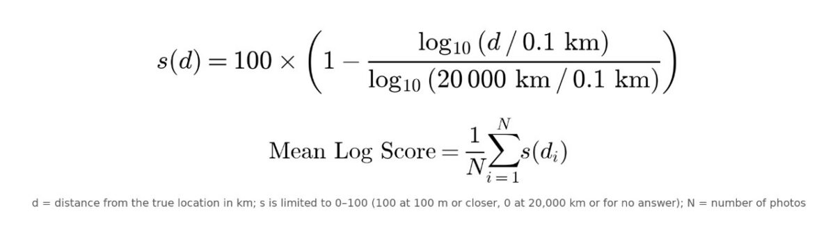
To compare model results, we used two metrics built on the distance in kilometres between a prediction and the real location. GeoGuessr Score was used to assess whether models could systematically identify the general area, while the Mean Log Score (explained below) measured which models most accurately pinpointed the correct location in the final few kilometres.
The GeoGuessr Score metric is based on the online game of the same name, whose scoring system Stanford University academics reverse-engineered in a 2024 study. This system rewards answers close to the general area an image was taken, but does not strongly distinguish between guesses close to the precise location. For example, an answer 200km from the correct location with more points than one 2,000km away. However, an answer 500m from where a picture was taken and another 5km away achieve a similar score. For real-world geolocations, that distance matters a great deal.
For more precision, we introduced a custom metric that grades models higher if they narrow down the search in the last few kilometres. This metric, the Mean Log Score, assigns a value from 0 (completely inaccurate) to 100 (perfect model) and works on a logarithmic scale instead of a linear one like GeoGuessr score.
Therefore, a 10-fold improvement in distance means the same whether it is from 5km to 500m or from 500km to 50km. You can compare both metrics here.
Below are the model results sorted by either metric, showing how many photos each model geolocated within distance bands from the true location.
Several models placed at least 10 out of the 52 photos correctly within one kilometre, and the top-performing models placed over 50 percent of the photos within 25 kilometres.
NOTE: Geoseer-fast refused to answer on four of the 52 photos, claiming “This image is not suitable for geolocation”, while Mistral-large-4 refused once with “insufficient information in image to identify location”. Kimi-k2.6 also failed to provide a set of coordinates on one photo, and Gemini 4 Argon timed out repeatedly on one photo.
Our Test
To independently assess the models, we sought to give them very specific instructions and some images that were harder to geolocate than those provided in our past tests. The prompt asked for a single set of coordinates reflecting the photographer’s location. The purpose of restricting the response in this way was to prevent hedging, such as multiple guesses or confidence scores, and make the grading more uniform across different models. Models were allowed to use their providers’ built-in tools: search, code execution and page fetch. We capped their token output at 64,000 and ran each model under its default effort setting with a maximum time of 15 minutes per photo. If a model did not return coordinates on the first prompt, we also allowed a single rescue prompt asking it to do so using its previous reasoning and without using any tools.
The images provided were unique, from around the world, not published on the internet before, scrubbed of metadata and provided without any context. They did not contain significant landmarks. We also included images in snowy, foggy and nighttime conditions.
The results show that the LLMs tested could, in many circumstances, successfully narrow down a location much faster than a human can geolocate even without any context. This is not limited to Google Street View-style images. Take, for example, this image of vegetation and a very small part of a rooftop.
An example of a photo used for testing, with annotation added after the test to highlight the only man-made object visible. Credit: Bellingcat.
For an average person, identifying the country this photo was taken in without any context could take a significant amount of time. However, multiple models quickly narrowed it down to Kenya. You can navigate their answers in the map below. Notice how several correctly inferred enough vegetation details to narrow down the exact part of the world and the park itself, but also that for many, the final response was a best guess only. It is important to note that even though some models were correct, others were significantly off.
The full model results for all 52 photos can be seen in the table below.
Of the models tested, Gemini 4 Argon scored highest on the Mean Log Score, and Claude’s models (Opus and Fable) were at the top of the table regardless of the score metric. Even Claude Sonnet, the weakest of its lineup, consistently came close to the real location while being the fastest to answer across all models.
This was followed by GPT-6 Astra and GPT-6.1 Sol, as well as other Claude and Gemini models, and then the geolocation-specific model, GeoSeer Fast, which provided good results but also timed out frequently. We tested GeoSeer’s more competent Agent model, but it refused to answer on eight photos and regularly timed out.
For secondary factors like time and cost, Claude also performed well on both metrics, and Gemini Argon, while much slower, came at a similar cost to Opus. Based on API rates, Argon and Opus models offered the best balance of accuracy and cost, especially compared to Fable and Grok. Grok was the most expensive option and had an underwhelming bottom-half performance. Meanwhile, GeoClip was freely available but only outperformed Claude Haiku.
Model Limitations
While we sought to analyse the most prominent models, there was one that we could not include as it has yet to be fully released.
Support Bellingcat
Your donations directly contribute to our ability to publish groundbreaking investigations and uncover wrongdoing around the world.
In its blog post, Anthropic claimed its Mythos model beats “even the strongest human baseline on median distance error, scoring 37.0km and 47.2km across 6,000 photos (placing 23.7 percent and 23.1 percent within 1km).“ But Nuno Moniz, Associate Research Professor at the Lucy Family Institute for Data & Society at the University of Notre Dame, told Bellingcat that “the median represents a strong simplification of what would be acceptable to compare AI-based system performance with regards to humans”.
Anthropic compared its models to competitive GeoGuessr players and their success in identifying the location of Google Street View images. The entire set of test images was online and there was no guarantee the models were processing the imagery for the first time.
While Anthropic has been relatively open about these methods, not all developers have been as forthcoming. It is therefore difficult to assess whether the same limitations will impact all other models, or whether there will be further caveats that we are simply not aware of.
Moniz said that “the increasing availability of benchmarking tools and datasets has made it somewhat difficult to measure reliability in test results such as these”. Specifically, due to the ”uncertainty as to whether that data was included in its training”. This is why we ran our Bellingcat tests with non-published photos sourced from Bellingcat staff and the Bellingcat Volunteer Community.
A further limitation of any models comparing performance to GeoGuessr scores is that the game uses images from Google Street View, which is limited to a select number of countries, and within these, a limited number of roads. Street View is also intentionally skewed to feature clear, high-quality photos taken during daytime that are useful for navigation, and users can pan around their view. There are also some well-known tricks that allow GeoGuessr players to bypass actual geolocation to correctly guess the location of photos: for example, Google is known to use a black car in Jordan and a white car in the UAE to capture imagery. While this wouldn’t necessarily impact model performance, it is a drawback of measuring against GeoGuessr score as the game has a set of workarounds that can bypass geolocation skill.
Anthropic’s data consisted of thousands of social media photos of various scenes. Once again, though, these photos were online and may have featured in the model’s training data. Anthropic’s blog post contained four images as an example of this dataset.
Images used as part of Anthropic’s dataset. Credit: Anthropic.
The examples Anthropic shared are relatively easy to geolocate as they feature recognisable buildings and signs. But footage that requires geolocation often comes from regions where access is limited and which do not feature on social media or Street View.
Specifically, in a military and intelligence context, footage often involves low-resolution material and intentionally obscured details recorded in remote or inaccessible areas. Context that could be found online can be uncertain or plain wrong, especially during a developing situation, such as the image below that Bellingcat investigators geolocated when verifying a US strike on a school in the city of Minab in Iran that killed at least 120 children earlier this year.
An example of footage geolocated by Bellingcat. Screen shot from Mehr News.
Anthropic researchers acknowledge this caveat, writing that it “does not as clearly emulate the task of precisely pinning down a location in near-real-time in a less populated battlefield setting; that is a task for future research.”
As noted, it is also possible that similar caveats need to be applied to other models when seeking to understand and interpret any geolocation-related benchmarking.
Supercharged Models
In parallel to the above models, we also tested a set of agentic skills and tools being developed internally by Bellingcat. These are researcher-informed instructions and code that can equip generic-use AI agents to augment their geolocation ability. For instance, we designed skills such as allowing it to download Environmental Systems Research Institute (ESRI) satellite imagery tiles. We also designed another skill that enabled direct access to data from Bellingcat’s OpenStreetMaps search tool, which aims to assist geolocation efforts by comparing items identified in imagery (like the position of a pylon compared to a nearby railway line) to OpenStreetMaps data. GeoSleuth is a similar project that has already been published, which we used for comparison. We picked Claude’s Opus 5.5 model to run both skills customisations because of its strong performance and reasonable pricing, and ran all the photos through the supercharged models under the same conditions – except that they had no timeout enforced as the supercharged models required more time to utilise their extra skills.
The different timeout conditions and expanded toolset do not allow for a direct comparison of the customised models to the previous off-the-shelf models’ results, even if they both outperformed the barebones Opus model they were based on, and all other models on GeoGuessr Score, with only Argon ranking above Bellingcat’s agent in Mean Log Score.
Still, this test allows us to showcase why skill customisations can bring value. Take the following photo.
An image captured at the Global Campus of Human Rights in Venice. Credit: Bellingcat.
This is not an exceptionally hard geolocation, and 11 of 17 models answered within 5km of the actual capture location in Venice, Italy. GPT-Sol answered with the correct monastery, but only Bellingcat’s agent and GeoSleuth answered with the exact camera position coordinates. This was possible because both model customisations can download and compare satellite imagery tiles, which allows them to validate not just which monastery the photo was taken at but also the correct courtyard position and orientation from visual cues. You can click the buttons in the list below to audit each model’s final answer.
While in this instance the supercharged models got the exact spot, there were other instances where they did not, as the scores in the results table above show. This again emphasises that even with extra skill sets added, these models were still far from infallible.
Tests Conclusions
Despite increased model improvement, our analysis shows that important caveats remain and it is important to keep a human in the loop when seeking to guarantee a geolocation is precise and correct.
Our tests show that the coordinates models provide as answers are rarely an exact match, even with supercharged models. Invariably, even the best models, with the best tools, can confidently claim a wrong position. Anthropic says its Mythos model was able to pinpoint less than a quarter of its social media photos dataset within a 1km radius. But narrowing down a location is rarely the trickiest part of geolocation work. A large part of important geolocation work is in the final stretch: finding specific coordinates from a general area. This level of specificity is needed because a general area is not a match. Matching features and perspective are necessary for an accurate geolocation, and in many cases that is done on very low-quality images or even by cross-referencing multiple sources.
This level of precision is essential for investigations where it matters what building a person could be found at, what lines of sight individuals might have had, or what impact an air strike might have led to.
Since LLMs can still confidently get things wrong, as our analysis shows, all results still have to be verified independently. Strong human geolocation skills therefore remain crucial, as the more one understands about geolocations, the better one can verify or take to completion an automated result.
Though it can speed up geolocation work significantly, especially in narrowing down an area of interest, AI models remain a useful assistant rather than a tool we can blindly delegate geolocations to.
Bellingcat is a non-profit and the ability to carry out our work is dependent on the kind support of individual donors. If you would like to support our work, you can do so here. You can also subscribe to our Newsletter and follow us on Bluesky here, Instagram here, Reddit here and YouTube here.
Sign up here to receive Bellingcat’s biggest investigations by email as soon as they are published.
WARNING: This report contains links to graphic images and footage.
A joint Bellingcat and Jeune Afrique investigation into drone strikes carried out by the Malian military adds new details about the attacks which frequently are carried out in civilian areas and have reportedly resulted in the deaths of civilians.
The incidents, concentrated in northern Mali, often involved strikes on vehi
Sign up here to receive Bellingcat’s biggest investigations by emailas soon as they are published.
WARNING: This report contains links to graphic images and footage.
A joint Bellingcat and Jeune Afrique investigation into drone strikes carried out by the Malian military adds new details about the attacks which frequently are carried out in civilian areas and have reportedly resulted in the deaths of civilians.
The incidents, concentrated in northern Mali, often involved strikes on vehicles or commercial activity. Video footage of the strikes is often broadcast on national television, portrayed as precise attacks against terrorists and their logistics.
Mali’s military government acquired its first Turkish-made Bayraktar TB2 drones in late 2022, and regularly releases footage of drone strikes to be broadcast on national television, describing them as “precise” and describing the targets as “terrorists and their logistics”. This month marks three years since Mali joined with Burkina Faso and Niger to form the Alliance of Sahel States (AES). Its military government has made restoring national sovereignty a central part of its political message.
Support Bellingcat
Your donations directly contribute to our ability to publish groundbreaking investigations and uncover wrongdoing around the world.
Bellingcat geolocated more than a dozen drone strikes including instances in which civilian deaths and injuries were reported. However, this represents just a fraction of the strikes that have taken place in northern Mali, with many more conducted for which footage was not available or further details were harder to verify as the locations are so remote.
Yvan Guichaoua Senior Researcher at the Bonn International Centre for Conflict Studies told us the Malian military’s drone strikes appeared to fit a pattern of “guilt by location” in which people may be treated as targets based on where they are rather than who they are.
He added that the broadcast of drone strikes on national television, often accompanied by dramatic commentary created a familiar narrative for veiwers that was akin to daily episodes “of a national saga”. Yet the impact of the drone war on civilians and non-combatants is seldom covered in such reports.
Mali’s civil war involves separatist and Islamist groups and has been ongoing since 2012, predating the formation of the AES. But the conflict has spiked in 2026 as Tuareg separatists from the Azawad Liberation Front (FLA) and militants from the al-Qaeda affiliated Jama’at Nusrat al-Islam wal-Muslimin (JNIM) seized control of parts of the country’s north in coordinated attacks against the Malian military and Russia’s Africa Corps forces. The Malian military (known hereafter by their official name Forces Armées Maliennes or FAMa) has relied heavily upon drone strikes in response.
We contacted FAMa and put our findings to them but did not received a substantive response at time of publication.
Destruction in Zouera
In one notable case – on July 8, 2025 FAMa presented a drone strike in the town of Zouera, in the Timbuktu region, as a successful operation against a supply vehicle for terrorists in footage broadcast on ORTM1 [4:50-5:31]. Drone footage shows a person walking near the vehicle before it is struck. The explosion immediately ignites a nearby structure, while several people can be seen running away.
One video of this incident, apparently showing the aftermath of the attack, shows the remains of a person inside the burnt-down structure, which was located directly beside the vehicle that was hit in the strike. We also checked satellite imagery and found a noticeable burn scar at the location in imagery taken on Jul 9, 2025, that wasn’t visible the previous day.
Bellingcat geolocated the strike site to the coordinates 16.84589, -3.85213, inside Zouera. Severalvideos filmed in the immediate aftermath show the destroyed vehicle, a large plume of black smoke, and the nearby structure engulfed in flames.
Geolocation diagram showing Google Earth satellite image (middle) with a screengrab of aftermath footage blurred by Bellingcat (left) and drone-footage shown on ORTM 1 (right). Sources: X/@AmakanessAg and Youtube.
Information gathered by Médecins Sans Frontières (MSF) and posted on X on July 11, 2025, stated four people were killed in the strike, including three young girls. MSF added that five others were treated for injuries at a local health centre, one of whom was in a serious condition.
#Mali : Après une frappe aérienne ayant touchée le marché de #Zouéra, cercle de Goundam, région de #Tombouctou, les équipes MSF ont pris en charge ce mardi 8 juillet 5 blessés, dont un cas grave, au centre de santé local. 4 personnes ont perdu la vie, dont 3 jeunes filles. pic.twitter.com/cTdLiY9bG8
— MSF Western & Central Africa (@MSF_WestAfrica) July 11, 2025
Amasrakad Strike
Zouera was not an isolated incident. Footage from March 2024 that was released by the Malian military and again aired on ORTM1 showed two drone strikes in the town of Amasrakad that resulted in the deaths of civilians, according to witness testimony and previous reporting by Amnesty International.
The footage shows an initial strike hitting a parked pick-up truck before cutting to a second strike on a nearby compound, where several people can be seen running moments before impact. The first strike was geolocated to the coordinates 17.08402, 0.76204, by France 24.
Bellingcat geolocated the second strike to a structure within a nearby compound at coordinates 17.081613, 0.768012, where the drone footage shows several people scrambling before impact. Separate graphic footagepublished by the Spokesperson for the Awazad Liberation Front on X the following day shows several dead people including what appeared to be women lying in and around the compound. France 24’s previous reporting on the strike included images of covered bodies inside a destroyed tent, as well as an image of a child that was reportedly injured during the strike.
Our partner Jeune Afrique obtained testimony from the man who filmed the footage. He said the second strike killed 13 members of two families, including several children, who had gathered in a tent for shelter after the first strike. He added that he helped take eight injured people to health centres. The man told Jeune Afrique he has now joined the separatist FLA group following the attacks.
This testimony would appear to support a 2024 Amnesty International report that stated at least 13 civilians, including seven children, were killed and more than a dozen people injured. Amnesty reported speaking to seven survivors and eyewitnesses who said the first strike hit a Toyota Hilux used by the local health centre. Believing the vehicle had been the target, residents fled to a nearby compound to seek shelter. The second strike then hit the compound directly, the Amnesty report stated.
Geolocation diagram showing Google earth satellite image (right), screengrab of aftermath footage (top-left) and screengrab of drone footage (bottom-left). Sources: X/@MohmedRAMADANE and Youtube.
The FAMa claimed in an official statement just after that attack that: “These operations neutralised several terrorists and destroyed a significant quantity of military equipment and vehicles.” While the pro-Azawad separatist group, the CSP gave a different account, condemning the strikes and claiming that they had killed 13 of which a majority were women and children.
We contacted FAMa to ask whether it maintains that those killed were members of an armed group, whether steps were taken to establish if civilians were present before the strike was carried out and whether an investigation was done into the reports of civilian deaths. We did not receive a reply at time of publication.
Two Strikes in Tinzaouaten
Some of the cases we geolocated had been documented previously. However, we were able to add new details about several strikes. The town of Tinzaouaten near Mali’s northeastern border with Algeria endured two major drone strikes in 2024, reportedly in retaliation for a major assault carried out by separatist and Islamist forces against Malian troops and Russian mercenaries. On July 30, 2024, the Malian military stated it had launched an air campaign around Tinzaouaten in coordination with the military government of Burkina Faso and had targeted “high-value targets”, including caches, logistics hubs and vehicles.
Pits and infrastructure which appear to be consistent with a mine are visible in satellite imagery of the area.
Diagram using Google Earth satellite imagery showing artisanal gold mining area in Tinzaouaten (19.93382, 2.98605), close to the Algerian border.
Bellingcat geolocated an additional videoposted by a pro-Azawad media outlet showing destruction posted on X to the coordinates 19.92502, 2.98013. In another video geolocated to this site, a man claims he is at the “Inkharaban mine, near the Azawad-Algeria border.”
A month later, on August 25, 2024, FAMa stated it had identified pickup trucks carrying military equipment in Tinzaouaten. It said that, “After careful surveillance, a series of strikes destroyed these terrorist targets and neutralized around twenty armed individuals.” On news channel ORTM1 the newsreader described the operation as “precision strikes targeting terrorist objectives”.
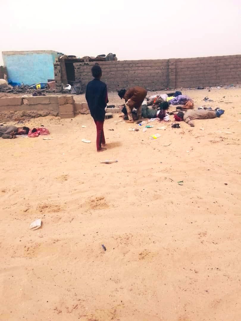
Bellingcat also geolocated two images showing casualties at this location. One image shows a group of around eight bodies, while another graphic image shows the bodies of two young boys around 20-meters away (19.9512, 2.97307). We could not confirm whether or not those pictured were civilians though a resident told Reuters that civilians were killed in drone strikes on the town.
Geolocation diagram using Google earth satellite image, with screengrabs showing casualties. Victims blurred by Bellingcat. Sources: X/@InfosMinutesFR.
Bellingcat contacted FAMa to ask about the two strikes in Tinzaouten in the summer of 2024. We asked the military what steps were taken to establish whether civilians were present when the strikes were carried out and whether any investigation has been carried out into the two strikes, but we had not received a response at time of publication.
In addition to the above incidents Bellingcat geolocated additional drone strikes based on footage broadcast on ORTM and added them to the below map. We were not able to confirm who was killed in the additional strikes but evidence we analysed show strikes often taking place within populated villages or against vehicles and fuel supplies.
Bellingcat has identified at least 80 police stations or infrastructure related to law enforcement agencies and the Basij paramilitary group that has been damaged or destroyed in the first three weeks of the United States and Israel’s war against Iran. Experts told Bellingcat that both countries aim to degrade the Iranian regime’s “repressive capacity”.
Combined, the US and Israel have conducted thousands of strikes during the course of the 2026 war in Iran. Targets range from Islamic Revolut
Bellingcat has identified at least 80 police stations or infrastructure related to law enforcement agencies and the Basij paramilitary group that has been damaged or destroyed in the first three weeks of the United States and Israel’s war against Iran. Experts told Bellingcat that bothcountries aim to degrade the Iranian regime’s “repressive capacity”.
Combined, the US and Israel have conductedthousands of strikes during the course of the 2026 war in Iran. Targets range from Islamic Revolutionary Guard Corps (IRGC) sites, Navy vessels to Iranian weapons manufacturers.
In early March, a Bellingcat analysis using satellite imagery and available photos and videos identified police stations as another apparent target, with at least 15 damaged or destroyed in the capital, Tehran.
We also identified multiple strikes against police infrastructure in the country’s north and west; these areas were targeted by the Israel Defence Forces according to a map released by the IDF on March 31.
“We are providing the brave people of Iran with the conditions to take their destiny into their own hands,” declared the Israeli Ministry of Foreign Affairs official X account, along with a photo of a destroyed police station.
اینجا کلانتری ۱۲۱ سلیمانیه در خیابان نبرد تهران بود.
ما شرایطی را برای مردم شجاع ایران فراهم میکنیم تا سرنوشت خود را در دست بگیرند. pic.twitter.com/VSm6YVvIwZ
In all, the majority of strikes Bellingcat analysed focused on police stations (30 incidents) and command centers or headquarters (29 incidents). Locations also include sites related to Basij, a plainclothes paramilitary organisation (9) affiliated with the IRGC that were “involved in the deadly crackdown” of protests in January 2026, others are associated with special forces (3) and traffic (2) or diplomatic (2) police compounds.
Due to commercial satellite companies limiting access to imagery over Iran and neighbouring countries we relied on Sentinel-2 imagery data to help verify the incidents, as well as videos and photos, some of which were also verified by independent geolocators and contributors to the Geoconfirmed volunteer community and confirmed by Bellingcat researchers.
Location data was partly determined using open source mapping data either from Wikimapia, OpenStreetMap or Google Maps. When video footage or photos were available for incidents reportedly targeting police stations, the location was verified with geolocation and satellite imagery analysis using either Planet Labs medium resolution PlanetScope data (restricted to imagery collected by March 9) or low resolution Sentinel-2 data.
Some locations were discovered utilising location data taken from OpenStreetMap using Overpass Turbo and comparing that with available Sentinel-2 data throughout Iran.
Map showing geolocated incidents in Iran. Click the markers to view the coordinates, sources, and verification notes. Map: Bellingcat/Miguel Ramalho
A Problem of Scale
Israel has released multiplevideos showing the targeting of bases and checkpoints belonging to the Basij. In mid-March, the IDF announced the killing of the paramilitary group’s commander, Gholamreza Soleimani.
Targeting the Basij is part of Israel’s and the US’ agenda “to degrade the regime’s repressive capacity,” Ali Vaez, the director of International Crisis Group Iran Project, told Bellingcat. Police stations are “not involved in repression in the way that crowd control police or Basij centers are”, so targeting them “appears more aimed at preventing the Islamic Republic from being able to maintain control internally,” he said.
Support Bellingcat
Your donations directly contribute to our ability to publish groundbreaking investigations and uncover wrongdoing around the world.
Vaez told Bellingcat that, when considered alongside the broader range of targets, including industrial factories, the widespread targeting of police stations is part of a strategy “to make Iran ungovernable for the existing regime or whatever comes after”.
Vaez was skeptical about the short term effects: “It’s a problem of scale. Iran is such a large country, even if you are able to completely destroy, not just degrade, the capacity of the regime in policing, oppressing, etc – it really requires not just maybe weeks but maybe months if not years.”
The Risk of Civilian Casualties
As of April 7, the Iranian Human Rights Activists News Agency estimates there’ve been more than 1,700 civilian fatalities during the war.
Several police stations are situated in densely populated urban areas such as Tehran. Stations are used by civilians for various reasons including renewing driving licences, so if these buildings are targeted “during working hours and not in the middle of the night then risk is higher for these people,” Vaez said.
Map showing geolocated incidents in Tehran. Click the markers to view the coordinates, sources, and verification notes.Map: Bellingcat/Miguel Ramalho
A recent joint Airwars, Center for Civilians in Conflict and Human Rights Activists in Iran report detailing the first month of civilian casualties included a section on the worsening situation for detainees in Iranian prisons — including police stations that have been targeted.
“I was detained in the holding cell of [Police Station 148] for ten days, along with four other activists. Now it looks like nothing is left of that station but ruins. I can’t even recognize where the detention area was. I keep wondering what happened to the people who were being held there during the attack. – Activist, told HRA upon seeing photos of the police station after recent US/Israeli airstrikes.”
Footage shared and geolocated by the BBC’s Shayan Sardarizadeh showed Police Station 148 damaged after an apparent strike in mid-March.
The main building of Tehran’s 148 police station and its courtyard, located on Enghelab Street, has been severely damaged in air strikes conducted on Friday.
The adjacent Hamoon Theatre also sustained some damage.
One destroyed police station identified by Bellingcat in the city of Mahabad in northwestern Iran led to apparent damage to an Iranian Red Crescent Society building located next door. According to Iran’s Tasnim News agency (an IRGC-affiliated media outlet sanctioned by the EU, the US and Canada), one Red Crescent employee was injured in the attack.
The police station adjacent to the Red Crescent building isn’t identified on any mapping services, though there are reports “Police Station 11” was targeted the same day.
Annotated Google Earth image showing the location of a destroyed police station and partially destroyed Red Crescent building in Mahabad, West Azerbaijan Province, Iran. A video shared on Telegram by mamlekate on March 6 shows the view of the destruction from the ground. Buildings behind the destroyed police station match with those seen in the Google Earth imagery.
Israel has also targeted checkpoints operated by Basij members.
Bellingcat examined two cases showing Israeli strikes on checkpoints while civilians were passing. In one video, a strike hits a checkpoint as five motorbikes and a vehicle go by.
View of a Basij checkpoint in Tehran targeted by the IDF. Immediately before the explosion is visible in the video, there are five motorbikes and a car next to the checkpoint. Source: YouTube/IDF
In another IDF video, a yellow bus is immediately adjacent to the checkpoint when it is hit. It is unclear how many people were on the bus at the time of the strike or if anyone was injured.
View of a Basij checkpoint in Tehran targeted by the IDF. Immediately before the explosion, there is a yellow bus visible next to the targeted checkpoint. Source: IDF
“I have been watching the reporting on these Basij strikes and the use of the Mikholit in particular in open urban areas. It is IDF standard—using precision munitions and even sometimes “low collateral” munitions but in a reckless manner that still puts the civilian population at risk,” Wes J. Bryant, a defence and national security analyst formerly with the Pentagon’s Civilian Protection Center of Excellence told Bellingcat.
Questions Over Legality
International Humanitarian Lawdefines civilians as “persons who are not members of the armed forces”. Police officers fall under that definition, according to Adil Haque, Professor of Law at Rutgers University and Executive Editor at Just Security. “As a rule, police are civilians and may not be attacked unless they take a direct part in hostilities,” Haque told Bellingcat. National security analyst Bryant agreed, adding that targeting police “does not stand up to legal scrutiny”.
Subscribe to the Bellingcat newsletter
Subscribe to our newsletter for first access to our published content and events that our staff and contributors are involved with, including interviews and training workshops.
In an email to Bellingcat, the IDF noted “that the police form part of Iran’s internal security apparatus, which also forms part of Iran’s armed forces, under Iran’s own domestic legislation. In every strike, the IDF takes feasible precautions in order to mitigate incidental harm to civilians and civilian objects to the extent possible under the circumstances.”
Police are indeed “part of the country’s armed forces. By that logic, anything with a flag on it is a legitimate target,” Ali Vaez, the director of International Crisis Group Iran Project, said.
Although Basij is a paramilitary group, any strikes against it would require precautions to minimise harm to civilians, Haque told Bellingcat. “Since the hostilities almost entirely involve aerial bombardment, the concrete and direct military advantage anticipated from strikes on Basij members who qualify as combatants is extremely low, so significant harm to nearby civilians would be disproportionate and illegal,” he said.
When asked about potential civilian casualties in the checkpoint strikes, the IDF told Bellingcat that since the Basij are subordinate to the IRGC and are therefore part of the armed forces, they are regarded as lawful military targets. Regarding the checkpoint strikes specifically, they stated “precision munitions and surveillance means were used in the strikes, as part of the precautions taken under the circumstances to mitigate expected incidental harm”.
Bellingcat reached out to US Central Command (CENTCOM) to ask if the US had any role in the police station strikes identified but received no official comment at the time of publication.
Miguel Ramalho and Felix Matteo Lommerse contributed to this report.
Bellingcat is a non-profit and the ability to carry out our work is dependent on the kind support of individual donors. If you would like to support our work, you can do so here. You can also subscribe to our Patreon channel here. Subscribe to our Newsletter and follow us on Bluesky here, Instagram here, Reddit here and YouTube here.
Bellingcat has geolocated and verified two new videos showing the deadly strikes that hit an Iranian Revolutionary Guard Corps (IRGC) compound as well as an adjacent school in the city of Minab in late February.
The new videos were released by Iran’s Ministry of Foreign Affairs and show multiple missiles hitting the complex.
One of the new videos shows the area around the school being struck while the other shows a nearby IRGC clinic and two buildings within the IRGC facility being hit by
Bellingcat has geolocated and verified two new videos showing the deadly strikes that hit an Iranian Revolutionary Guard Corps (IRGC) compound as well as an adjacent school in the city of Minab in late February.
One of the new videos shows the area around the school being struck while the other shows a nearby IRGC clinic and two buildings within the IRGC facility being hit by Tomahawk missiles.
Support Bellingcat
Your donations directly contribute to our ability to publish groundbreaking investigations and uncover wrongdoing around the world.
Visual and solar analysis of the videos appears to show there was a time gap between when each was filmed, suggesting that there were at least two waves of strikes carried out in the area.
Applying the same solar analysis techniques to social media footage that showed the school after it had been hit indicates the school was impacted during the first wave of strikes.
Previous investigations by Bellingcat and other news organisations showed a US Tomahawk missile struck the IRGC facility on Feb. 28.
The US is the only party to the conflict to possess Tomahawk missiles.
Media reports, including from the New York Times and Reuters, have since detailed that a preliminary investigation by the US military concluded it was likely a US strike that hit the Shajarah Tayyebeh elementary school.
According to Iranian media, at least 175 people were killed in the attack, including children.
Analysing New Minab Videos
The first video (video one) is filmed from just over 2.5 kilometres (1.5 miles) away from the IRGC base and shows at least 10 missiles impacting the area over a period of 50 seconds.
The first explosion is visible five seconds into the video. The area around where the school was located is struck at 14 seconds. This is the fourth explosion visible in the footage.
Another structure that was damaged in the strikes is situated approximately 100 metres away from the school in the same general area. It was therefore not possible to determine which exact structure was hit from this footage alone.
Screenshot of Video one showing 10 missiles striking the area. The fourth impact hits the area round the school (white box), seconds after the first three explosions. Annotation by Bellingcat. Source: Tasnim News.
The second new video (video two) was filmed approximately two kilometres southeast of the school, and is of a higher quality than video one. This video shows three Tomahawk missiles in the moments before impact.
Screenshots from Video two showing each Tomahawk missile before impact. Annotations added by Bellingcat. Source: Iran Ministry of Foreign Affairs.
Video two includes annotations and pauses when each Tomahawk appears on screen.
A frame-by-frame analysis also shows what appear to be two minor visual glitches where some frames are transposed and annotations were added, highlighting when missiles can be seen.
The second impact seen in video two is the same as seen in footage released by Iranian media in early March, and previously reported on by Bellingcat and others, only from a different perspective.
Video two also only shows the southern part of the base, with its northern section not visible. The school is located on the northern edge of the base and is therefore not visible in video two.
Left: Tomahawk missile strike in footage previously published showing Tomahawk strike in Minab. Right: The same strike visible in Video two. Sources: Mehr News and Tasnim News.
Bellingcat asked the Iranian Ministry of Foreign Affairs why only part of the strike, as seen in video one, was released and if there was a longer version that may show further impacts. We did not receive a response before publication.
Bellingcat also asked the US Department of Defense whether it had any further information on the strike since its reported preliminary findings. It referred us to CENTCOM, which said: “We have nothing for you on this. The investigation is still ongoing.”
Geolocating the Videos
Bellingcat was able to geolocate and verify video one by tracing sightlines on satellite imagery to determine the camera’s location and identify objects such as buildings, trees and a water tower within the IRGC facility.
According to this analysis, video one was most likely filmed from an electric substation southeast of the school.
Left: Screengrab from video one. The dashed vertical lines represent the intersection of planes of constant angle with the image plane. These planes connect the center of the camera and enable the selected elements to be geolocated. Right: annotated satellite imagery showing the corresponding perspective lines and the geolocated elements. The analysis allowed us to identify, geolocate buildings and locate the explosion points. Annotated by Bellingcat. Source: Tasnim News. Satellite Image: Google Earth/Airbus
Once all key elements were identified and geolocated, we analysed each explosion that can be seen in the footage.
Fourteen seconds into video one, the fourth impact appears to hit the area immediately around the school, which was approximately 200 meters behind a water tower.
While the school was walled off and outside the IRGC facility, the water tower and another building (situated between the school and the water tower) are located within it.
Due to the relatively small distance between the school and the other IRGC building (roughly 100m), it was not possible to determine what structure was hit at the moment of the strike visible in video one.
More information, such as obtaining the entire strike video sequence, would be needed to fully determine which structure was hit in this footage. However, social media footage captured at the scene does suggest that the school was hit around this time.
Left: Line of sight passing by the yellow building intersects the point of forth explosion from behind the IRGC water tower. Center: Direction of line of sight intersects school and passes close to a nearby IRGC building. Both buildings were damaged in the attack. Right: Satellite image showing both the school and IRGC building. More details would be needed to determine which of both buildings were hit in this video. Satellite image: Google Earth/Airbus
For video two, we stitched together a rough panorama of what could be seen in the footage.
This made it possible to match up multiple buildings visible southeast of the IRGC base and school, while also building rough sightlines to show which part of the base was being filmed.
Annotated geolocation with Google Earth imagery showing key visual elements visible in the stitched panoramic from the end of Video two and their corresponding locations in satellite imagery. Source: Tasnim News. Satellite Image: Google Earth/Airbus/Maxar.
Bellingcat was able to narrow down the areas hit by the three missiles seen in video two by comparing it with the point of view of a short video released in early March, showing a Tomahawk hitting the complex, as well as with what could be seen in video one. Post-strike satellite imagery also helped confirm the buildings that were hit in the footage.
We were thus able to determine that video two shows an IRGC clinic and two buildings within the IRGC compound being hit.
Left: Planet SkySat imagery of the IRGC Base, and the adjacent school and health clinic, collected March 04, 2026 after the strikes. Annotated by Bellingcat. Right: Screenshots of the three explosions in video two. Sources: Planet and Iran Ministry of Foreign Affairs
Initial analysis did suggest that video one and two appeared to be filmed at different times as the strikes visible in each clip cannot be synced up.
Solar data also gives clues as to the time each was taken, suggesting that there was a time gap of at least an hour between the strikes seen in the two videos.
According to the New York Times, the strikes were first reported on social media just after 11:30 am.
Solar data, derived by the direction of shadows visible in video one and simulated via the SunCalc platform, appears to indicate it was filmed between 10:30 and 11:30am.
Left: Screengrab from video one showing an object on a roof casting a shadow consistent with a time between 10:30-11:30 a.m on February 28 2026. Right: Solar data simulation center on the object. Source: Tasnim News, SunCalc.org
Analysing the shadows seen in the earlier March video using the same method, appears to show that it was filmed between 13:30 and 14:30.
This would seem to indicate that video two and the earlier March video were likely filmed after video one.
Left: Screengrab from earlier March video showing rebars casting a shadow parallel to the building construction and consistent with a time between 13:30-14:30 on February 28 2026. Top Right: Solar data simulation center on the object. Bottom Right; Satellite image showing the shadow direction along the building line. Source: The Washington Post, SunCalc.org. Satellite Image: Google Earth Pro/Airbus
Solar data from a video posted to Telegram showing the smouldering school, and damage to the nearby IRGC building about 100m away, shows that it was recorded around the time of the first video.
Left: Screengrabs from a video released the day of the strikes, showing the destroyed school (blue), and damaged roof of the IRGC building about 100m away (red box). Inset: Planet SkySat imagery showing this building (red) and the school (blue). Right: The shadow cast by the bystander is consistent with a time between 11:00-12:00 on February 28 2026. Right: Solar data simulation centred on where the bystander was standing.. Sources: Mehr News, Planet, and SunCalc.
This, therefore, appears to confirm that the school was impacted before the wave of attacks seen in video two.
Bellingcat was not able to verify where the remnants were originally found, but was able to identify them as Tomahawk missile remnants. The New York Times also confirmed this identification by matching the contract number on a remnant to a contract for the Tomahawk missile.
Bellingcat’s Carlos Gonzales, Jake Godin and Trevor Ball contributed research to this article.
Bellingcat is a non-profit and the ability to carry out our work is dependent on the kind support of individual donors. If you would like to support our work, you can do so here. You can also subscribe to our Patreon channel here. Subscribe to our Newsletter and follow us on Bluesky here, Instagram here, Reddit here and YouTube here.
To stay up to date on our latest investigations, join Bellingcat’s WhatsApp channel here.
Bellingcat has geolocated footage of multiple Tomahawk cruise missiles travelling through Iraqi airspace towards Iran, either in violation of its airspace or with Iraq’s consent.
Bellingcat identified at least 20 individual cruise missiles and geolocated them over Iraqi Kurdistan including alongside Mount Piramagrun, in the Zagros Mountain range, and approximately 50 km southeast of the city of Kirkuk
To stay up to date on our latest investigations, join Bellingcat’s WhatsApp channel here.
Bellingcat has geolocated footage of multiple Tomahawk cruise missiles travelling through Iraqi airspace towards Iran, either in violation of its airspace or with Iraq’s consent.
Bellingcat identified at least 20 individual cruise missiles and geolocated them over Iraqi Kurdistan including alongside Mount Piramagrun, in the Zagros Mountain range, and approximately 50 km southeast of the city of Kirkuk.
The US is the only participant in the war known to possess Tomahawks, which can be launched by ships or submarines. US President Donald Trump said at a press conference on Monday that Iran “also has some Tomahawks”. Official government reports on Iran’s military balance don’t support this claim.
Considering the distance of US vessels to the geolocated missiles, the missiles seen in the videos were most likely fired from the Mediterranean Sea, Sam Lair, a research associate at the James Martin Center for Nonproliferation Studies, told Bellingcat.
Red Sea launches would be pushing the maximum range, and US Navy ships were not known to have been in the Persian Gulf at the start of the war, Lair said.
Brian Finucane, a senior adviser with the US Program at the International Crisis Group, told Bellingcat that without the consent of Iraq and Syria, the intrusion of Tomahawk missiles into their airspace “would violate its sovereignty and international law”.
We asked the US State Department and Department of Defense as well as the foreign ministries of Iraq and Syria, if the US had an agreement with Iraq or Syria to utilise their airspace for cruise missiles targeting a third country. The Department of Defense told Bellingcat they “had nothing to provide” while neither the Iraqi nor Syrian ministry had responded at the time of publication.
On Tuesday, Iraqi Prime Minister Mohammed Shia al-Sudani spoke with US Secretary of State Marco Rubio and stressed that Iraqi airspace and territory should not be used for any military action targeting neighbouring countries, the prime minister’s media office said.
Bellingcat geolocated at least eight videos showing Tomahawk missiles over Iraq. The videos show at least 20 individual Tomahawk missiles, based on the longest uninterrupted video we reviewed.
The below graphic shows all Tomahawk missiles Bellingcat has geolocated, which includes additional missiles identified outside of Iraq.
Click the arrows in the map below to view the verified missile sightings, including the original footage and geolocation analysis.
Interactive map showing the approximate locations of US carrier groups in the region at the start of the war, with a 1600 km range, in relation to Tomahawks geolocated by Bellingcat. We included a possible Red Sea launch point for visualisation, reference and comparison purposes only. The white arrows indicate the location of Tomahawk sightings. Their respective directions of travel are shown by default. All coordinates and directions shown are approximate. Source: Logan Williams/Bellingcat.
These missiles don’t always make it to their intended target. In addition to footage of the airborne missiles, Bellingcat also identified remnants of a Tomahawk missile that had crashed outside Kafr Zita in northwest Syria.
Unexploded WDU-36/B warhead of a Tomahawk missile, outside Kafr Zita, Syria. Source: Qalaat Al Mudiq.
Missiles Fired From the Sea
On the first day of the war, Feb 28, the US Central Command (CENTCOM) published footage of Tomahawk missiles being fired from the sea. Later on March 1, CENTCOM released additional video of the USS Thomas Hudner (DDG-116) firing a Tomahawk missile, while operating in the Eastern Mediterranean Sea.
According to a Center for Strategic and International Studies (CSIS) analysis, more than 160 Tomahawk missiles may have been used in the first 100 hours of the war, and “they would have been used to destroy Iranian air defenses and other counter-air capabilities and create permissive conditions for follow-on attacks”.
Arleigh Burke-class guided-missile destroyer USS Thomas Hudner (DDG 116) fires Tomahawk land attack missiles in support of Operation Epic Fury, Mar. 1, 2026. (U.S. Navy video)
Tomahawk Flights Through Iraqi Airspace
The footage analysed by Bellingcat showing cruise missiles travelling over land is consistent with the typical flight profile of Tomahawks, which cruise at low altitude along pre-programmed routes toward distant targets.
Support Bellingcat
Your donations directly contribute to our ability to publish groundbreaking investigations and uncover wrongdoing around the world.
According to the US Navy, “Tomahawk cruise missiles are designed to fly at extremely low altitudes at high subsonic speeds, and are piloted over an evasive route by several mission tailored guidance systems.”
This explains why they are sometimes filmed by civilians during transit. Similar sightings have previously been recorded during US conflicts in the Middle East.
Bellingcat analysed terrain features and solar data in the footage and confirmed the location and approximate direction of travel of the Tomahawk missiles. We found that they followed the terrain closely, and appeared to follow two different valleys near the Iraq-Iran border.
The Zagros mountain range stretches across much of Iran as well as northern Iraq. The mountains of this valley would provide details for the Tomahawks’ terrain matching guidance, and hide them from Iranian radar detection.
Click the arrows in the map below to view the verified missile sightings, including the original footage and geolocation analysis.
Interactive map showing the locations of Tomahawk sightings. The missiles were travelling through Iraqi airspace towards Iran in valleys near the Iraq-Iran border, and near Kirkuk. The respective directions of travel are shown (white arrows). All coordinates and directions shown are approximate. Source: Logan Williams/Bellingcat.
Other Geolocated Footage
In a video filmed in Tehran and posted on the first day of the war, six Tomahawk missiles can be seen flying over the Qurkhane Bus Terminal in Tehran, as an anti-aircraft gun on a nearby building fires at them. Other gunfire can be heard in the distance.
A Tomahawk flying over the area near Qurkhane Bus Terminal in Tehran, as an anti-aircraft gun on a nearby roof fires at it. Source: Vahid Online.
A final video analysed by Bellingcat, posted on March 3, shows 13 Tomahawk missiles flying past a commercial ship in the direction of Iran, the M/V MAERSK BOSTON, while it was off the coast of Oman, according to solar, visual and Marine Traffic data.
A Tomahawk flying past the MV MAERSK BOSTON off the coast of Oman. Source: Warren Wright Olanda.
New Tomahawk Variants
Since the beginning of the war, two new variants of Tomahawk missiles have been observed.
Typical Tomahawk configuration, with wings slightly angled towards the rear. Left: View of the bottom of a Tomahawk as it dives towards its target during a test. Right: View of the top of a Tomahawk as it dives during a test. Sources: Commonwealth of Australia, Department of Defence.
One Tomahawk variant seen publicly for the first time, distinguished by its visible black body, believed to be a stealth coating. Other missiles appear to have wings angled forwards, a modification designed to make them harder to detect by radar, according to an analysis by The War Zone.
Tomahawk missile with forward swept wings. Source: Channel8.
Clobbering
Sam Lair, a research associate at the James Martin Center for Nonproliferation Studies, told Bellingcat that Tomahawks have GPS guidance and use terrain matching to determine their location. When there is an error in guidance, some missiles can “clobber” and hit the ground.
The US stopped firing Tomahawk missiles over Saudi Arabia during the 2003 Iraq War after some crashed in the country while attempting to strike targets. About ten Tomahawk missiles crashed during that war, with some landing in Iran and Turkey as well.
Bellingcat’s Logan Williams and Felix Matteo Lommerse contributed research to this article. Livio Spani, Anisa Shabir, Afton Briones, Mathis Noizet, and Nicole Kiess from Bellingcat’s Volunteer Community also contributed to this piece.
Bellingcat is a non-profit and the ability to carry out our work is dependent on the kind support of individual donors. If you would like to support our work, you can do so here. You can also subscribe to our Patreon channel here. Subscribe to our Newsletter and follow us on Bluesky here, Instagram here, Reddit here and YouTube here.

 Entrar