Visualização normal

Antes de ontemAnalyst
  • ✇bellingcat
  • Tracking a Sanctioned Russian Vessel’s West African Odyssey Bellingcat Investigation Team
    Sign up here to receive Bellingcat’s biggest investigations by email as soon as they are published. A sanctioned vessel that was previously reported to have transported weapons destined for Russian mercenaries has been traversing ports on the west coast of Africa since March, exhibiting what experts told Bellingcat  was an unusual set of movements and behaviours. Patria (IMO: 9159921) has been sanctioned by the US, Ukraine and Canada. Support Bellingcat Your donations directly co
     

Tracking a Sanctioned Russian Vessel’s West African Odyssey

25 de Agosto de 2026, 05:52

Sign up here to receive Bellingcat’s biggest investigations by email as soon as they are published.

A sanctioned vessel that was previously reported to have transported weapons destined for Russian mercenaries has been traversing ports on the west coast of Africa since March, exhibiting what experts told Bellingcat  was an unusual set of movements and behaviours.

Patria (IMO: 9159921) has been sanctioned by the US, Ukraine and Canada.

Support Bellingcat

Your donations directly contribute to our ability to publish groundbreaking investigations and uncover wrongdoing around the world.

Radio France International (RFI) reported last year that it was one of two ships to deliver weapons to Conakry in Guinea that were intended for the Kremlin-controlled Africa Corps and their operations in Mali.

Satellite imagery and Automated Identification System (AIS) data from Lloyd’s List Intelligence shows Patria has shuttled between the Port of Douala in Cameroon and the Port of Owendo in Libreville, Gabon four times since March. 

It has also twice stopped in anchorage off the coast of Lagos, Nigeria: first in March and then again at the time of publication. Analysis shows the vessel also spent time in anchorage off the coast of Equatorial Guinea. 

The online news site, Modern Ghana, first reported Patria’s presence off the coast of Lagos in July after X-users @SONNAROW_OSINT and @RFNOSBlog picked up on Patria’s position.

It is not clear what Patria has delivered or picked up at these ports. Nor is it clear why it has spent so long going back and forth between them. But experts Bellingcat spoke to said the unusual patterns of behaviour raised numerous questions.

Charlie Brown, a former US Naval Officer and Senior Advisor at United Against Nuclear Iran said the combination of Patria’s repeated regional port calls, extended periods at anchor, and an apparent absence of a normal point-to-point trading cycle warranted scrutiny, especially as the ship is under sanction and is previously reported to have shipped arms. 

Tracking the Patria

Patria is a cargo vessel that has a distinct shape and features. Its bridge is located on the bow and it has a bright red deck that contrasts with its blue hull and two yellow cranes. 

At the end of the deck, the ship has a built-in ramp for vehicles (the Patria is a so-called roll on/roll off, or RoRo, vessel that is designed to transport wheeled vehicles). Its chimney is located next to the ramp.

Footage of the Patria, posted on Youtube on Jan 22, 2024. Credit: Hanro Shipping – Sakhalin Projects LLC / YouTube Channel @hanroship

This, in combination with the length of the ship (101 m), allowed Bellingcat to pick the vessel out in satellite imagery. AIS data helped us further track its long journey which began in the Sea of Japan, in Russia’s far-east, in January.

For the most part, we were able to match Patria’s AIS position with corresponding satellite imagery. We found no evidence of obvious spoofing incidents (where a ship intentionally broadcasts misleading AIS data) by the vessel during its months-long voyage, however, there were some instances where satellite images were not available and thus spoofing by the vessel cannot be completely ruled out.

MapLibre | Protomaps© OpenStreetMap contributors

Port of Olga, Russia

AIS data indicates that Patria loaded at the Port of Olga in the Sea of Japan between Jan. 21 and 23. Patria can also be seen on satellite imagery on these dates.

Credit: Planet Labs PBC.

Port of Douala, Cameroon

AIS data indicates that Patria unloaded some cargo in the Port of Douala between Mar. 11 and 12. Again, the ship can also be seen in satellite imagery on these dates.

Credit: Planet Labs PBC.

Lagos Anchorage, Nigeria

AIS data indicates Patria anchored off the coast of Lagos from Mar. 14 to 15.

A Sentinel-2 image from the 15th appears to show another ship next to Patria. AIS data indicates that this is JS Gratitude, a bunkering tanker. This close proximity suggests that Patria was refuelling.

Credit: Contains modified Copernicus Sentinel data 2026.

Bata Anchorage, Equatorial Guinea

AIS data and satellite imagery indicate Patria stayed off the coast of Equatorial Guinea for several days.

Credit: Planet Labs PBC.

Port of Owendo, Libreville, Gabon

AIS data and satellite imagery indicate Patria loaded at the Port of Owendo in Libreville after spending a few days off the coast.

Credit: Planet Labs PBC.

Port of Douala, Cameroon

AIS data and satellite imagery indicate Patria stayed at the Douala Anchorage from Apr. 6 to 14, before unloading at the Port of Douala between Apr. 14 and 18.

Credit: Planet Labs PBC.

Port of Owendo, Libreville, Gabon

AIS data suggests Patria loaded in Libreville again between Apr. 22 and 26.

Port of Douala, Cameroon

AIS data, supported by satellite imagery, indicates Patria stayed at the Douala Anchorage for nearly a month from Apr. 27 to May 21 before unloading in Douala from May 21 to 27.

Credit: Planet Labs PBC.

A third trip between the Port of Owendo, Libreville to Douala, Cameroon

AIS data indicates, after nearly a month’s wait in Douala anchorage, Patria again loaded at Owendo before returning to Douala to unload.

A fourth trip between the Port of Owendo, Libreville to Douala, Cameroon

AIS data indicates Patria again loaded at Owendo before returning to Douala to unload.

Lagos Anchorage, Nigeria

AIS data indicates, after a short visit to the Libreville anchorage, Patria anchored off the coast of Lagos where it remained at the time of publication.

Credit: Planet Labs PBC.

Examining the Patria’s Draught

We reviewed the draught of the ship at each port visit and found that the ship’s draught always dropped after a stay at the Port of Douala, suggesting it was unloading there.

A ship’s “draught” is the distance from the bottom of the hull (the keel) to the waterline. When loaded, a ship is heavier and sits lower in the water (e.g. a draught of six metres) than when it is unloaded (e.g. a draught of four metres).

Draught is the depth of a ship below the waterline. 

In the period from March to July, the Patria made five port calls to Douala and each time the draught decreased. Conversely, it called four times at the Port of Owendo in Libreville, each time the draught increased, meaning the ship became heavier, suggesting it was loading.

The draught is self-reported by ships but usually when it arrives at ports this kind of data is checked – reporting accurate draught is also a safety issue for ships arriving and departing at ports. 

Bellingcat asked the ship’s owners, managers and both ports if items were being transferred from Libreville to Douala but did not receive a response at time of publication.

Brown, the former US Naval Officer and now a Senior Advisor at United Against Nuclear Iran, said Patria’s movements were unusual.

“A sanctioned vessel linked to a prior military logistics shipment spending nearly six months operating between a small cluster of West African ports, Douala, and Owendo, without returning to a clear commercial trading pattern warrants scrutiny,” Brown told us.  


“While innocent explanations such as mechanical issues, commercial disputes, lack of cargo, chartering delays, or prolonged maintenance are possible, the combination of repeated regional port calls, extended periods at anchor, and an apparent absence of a normal point-to-point trading cycle is atypical for a merchant vessel.” 

He added that the current period of more than 30 days at the Lagos Anchorage, in particular, is noteworthy. 

David Soud, Head of Research and Analysis at I.R Consilium also told Bellingcat that Patria’s prolonged Lagos Anchorage could have innocent explanations such as its need for ongoing repairs, or that its operators were out of money, but added that there could also be more calculated reasons and it was laying low for a while.

Bellingcat analysed AIS data from Lagos Anchorage and found that while there has been high congestion, no other RoRo or container vessel waited longer than 10 days to enter the port in the period that Patria has been at Lagos Anchorage. At time of writing, Patria has been in anchorage for more than 30 days.

Regarding the Patria’s apparent deliveries of cargo between Libreville in Gabon, and Douala in Cameroon, Soud told Bellingcat:

“Given the vessel’s history of transporting military equipment to African seaports for overland delivery to Russian and allied forces in the Sahel, it’s not out of the question that some form of supplies for Russian or other forces could be picked up in Gabon, whose government has developed a closer relationship with Moscow, to be discharged in Douala, which is the main entry point for goods going to Central African Republic.”

Bellingcat asked the Nigerian Ports Authority why Patria had been in anchorage for so long, whether it had applied to dock and whether the port was aware of its sanctioned status but did not receive a response at time of publication.

The ports of Douala in Cameroon and Owendo in Libreville, Gabon did not respond to Bellingcat’s requests for comment about the Patria’s visits and the cargo it was carrying.

Bellingcat also contacted the two companies connected to the vessel – Hanro Shipping and Sakhalin Shipping Company which are listed as the vessel’s owner and manager respectively in sanctions documents. We also contacted the company connected to JS Gratitude. We did not receive a response at time of publication.


Youri van der Weide, Galen Reich, Yörük Işık contributed to this report.

Cover image: Planet Lab image shows the Patria at the Port of Douala, Cameroon, on April 17, 2026. Credit: Planet Labs PBC.

Bellingcat is a non-profit and the ability to carry out our work is dependent on the kind support of individual donors. If you would like to support our work, you can do so here. Subscribe to our Newsletter and follow us on Bluesky here, Instagram here, Reddit here and YouTube here.

The post Tracking a Sanctioned Russian Vessel’s West African Odyssey appeared first on bellingcat.
  • ✇Schneier on Security
  • On Flock License Plate Tracking Cameras Bruce Schneier
    A recent story of a writer who was mistakenly identified, tracked, and arrested using data from Flock cameras has gone viral. The New Jersey plates that were allegedly stolen from the LA dealer were 34 03 DTM, not 34 10 DTM. But when the police report was created and the plate was entered into Flock’s system, it was just recorded as 34 DTM. Just the five large characters, no little number in the middle. And Flock’s AI tech wasn’t registering that non-standard little number when it began picking
     

On Flock License Plate Tracking Cameras

20 de Julho de 2026, 08:03

A recent story of a writer who was mistakenly identified, tracked, and arrested using data from Flock cameras has gone viral.

The New Jersey plates that were allegedly stolen from the LA dealer were 34 03 DTM, not 34 10 DTM. But when the police report was created and the plate was entered into Flock’s system, it was just recorded as 34 DTM. Just the five large characters, no little number in the middle. And Flock’s AI tech wasn’t registering that non-standard little number when it began picking up the Range Rover around town. It just saw 34 DTM in large type and started alerting the local police.

As we all stood there shaking our heads, including my wife, who was finally allowed to join me, I connected the final dot. A lot of vehicles in JLR’s media fleet have a New Jersey manufacturer plate with the same alphanumeric structure­34 ## DTM­and Officer Ganshyn observed that meant it was now a nationwide issue. Anywhere a police department has a partnership with Flock, any other JLR-owned car with the same plate structure is going to get flagged as stolen. In fact, four other 34 ## DTM cars were being tracked around Minnesota that week, according to Officer Ganshyn. I was just the first one to get nabbed. The only way to stop it would be for the LAPD to correct their initial report and update Flock’s system, which Jaguar Land Rover was now racing to make happen following the phone call.

Flock has responded to the bad press. First, they affirmed that their systems were working correctly, and blamed the police:

The obvious question was that Flock cameras were looking for 34 DTM, and the plate on the car I was driving was 34 10 DTM. Why was that flagged as a match?

“The way that the ML [machine learning] works is it correctly read what it was supposed to read. It was fed those characters that you said, 34 DTM, and it spit back out [a result] with the characters, 34 DTM,” Thomas said. “It was asked, can you find this? And it did find that. It just didn’t say if there’s more here, then don’t do it. It just simply said, is it there? And the answer was yes.”

He explained that even if the 10 was normal size, Flock would still have flagged it as a match, because that’s how they’ve set it up according to law enforcement’s requests. Sometimes partial plates are all they have to go on at first.

“The way that law enforcement likes to use these tools is, if any of the characters that they have put into these hot lists get read, they want to get those alerts,” he said. “Now, what we try to train officers to do is to do what you said, which is to verify that 34 DTM is what I’m looking for, and what I’m seeing is 34 10 DTM.”

Second, Flock’s CEO has apologized for calling privacy advocates terrorists:

The CEO of Flock Safety, the company that runs an enormous network of cameras used by police departments across the U.S., hasn’t been shy about taking on Flock’s critics. Last year, he even called one group that tracks the location of Flock cameras “terrorists.” But he’s had a change of heart. Or, at the very least, a change in PR strategy.

Meanwhile, the police are using (alternate source) the Flock camera network to track people in addition to cars:

Police departments around the country have used Flock cameras at least hundreds of times to search for specific people, not cars, using searches such as “heavy-set male with a black and white hat,” “person on skateboard,” and “person wearing orange vest and construction hat,” according to data reviewed by 404 Media. Sometimes searches reference a target’s race or signs of their political affiliation.

And, like all police surveillance technologies, there are abuses.

  • ✇bellingcat
  • Heading Off: New Technique Helps Track Grain Smuggling Expansion to Libya Bellingcat Investigation Team
    On February 15, 2026, the bulk carrier, Grumant (IMO: 9385879) was pictured at the occupied Ukrainian Port of Feodosia on the Crimean peninsula. Satellite imagery suggests it had already been there for several days.  It appeared to stock up on grain before departing on a two-month-long journey eventually docking at the Port of Benghazi in Libya on April 18. While there have been previous reports of grain shipments from occupied Ukraine arriving in Libya, this is only the second time a Russian
     

Heading Off: New Technique Helps Track Grain Smuggling Expansion to Libya

12 de Junho de 2026, 05:51

On February 15, 2026, the bulk carrier, Grumant (IMO: 9385879) was pictured at the occupied Ukrainian Port of Feodosia on the Crimean peninsula. Satellite imagery suggests it had already been there for several days.  It appeared to stock up on grain before departing on a two-month-long journey eventually docking at the Port of Benghazi in Libya on April 18.

While there have been previous reports of grain shipments from occupied Ukraine arriving in Libya, this is only the second time a Russian ship has been observed delivering what the Ukrainian government describes as “stolen” grain to the country. The previous case involved the Damas Wave which travelled in January of last year to the port of Misrata which is under the control of the UN-recognised Government of National Unity (GNU). In addition to satellite imagery, Bellingcat deployed a new technique that analysed Grumant’s heading data which was contained in AIS information provided by Lloyd’s List Intelligence, to help confirm Grumant’s presence in Feodosia. 

Bellingcat has been tracking smuggled Ukrainian grain shipments as they find new markets, five of the ships we previously identified have since been sanctioned by the EU while another was sanctioned by the US Department of Treasury.

MapLibre | Protomaps© OpenStreetMap contributors

Bosphorus Strait

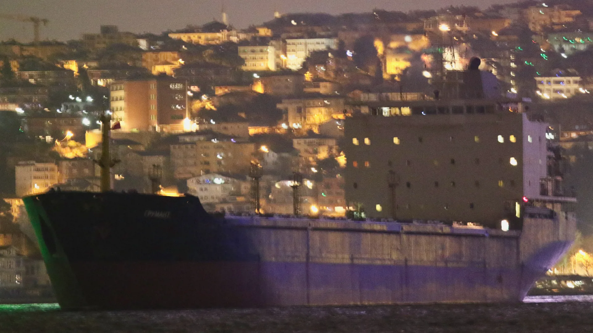
Grumant transits the Bosphorus Strait in the middle of the night.

Credit: Yörük Işık.

Black Sea

Grumant enters a region of the Black Sea known for GNSS interference, meaning that Grumant’s publicly reported Automated Identification System (AIS) position is unreliable.

Port of Feodosia

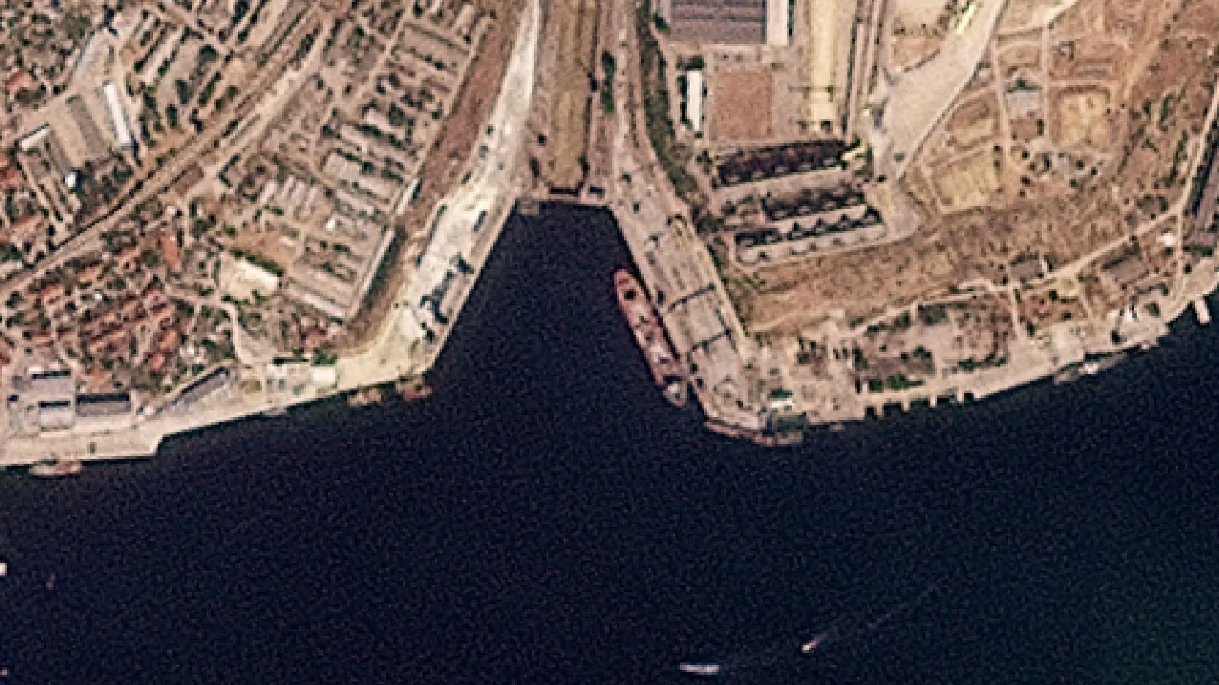
On February 15, a high resolution satellite image confirms the ship is docked at the port of Feodosia at berth No. 1 that is used for bulk and metal cargo. Matching features visible include Grumant’s grey decking, its seven hatches and bright yellow front mast. What appears to be leftover grain can be seen under the two port crates, immediately next to the ship.

Credit: Satellite image ©2026 Vantor.

Black Sea

Grumant exits the area of signal interference, meaning that its reported position on ship tracking services is now reliable again. Its AIS messages indicate it is travelling towards the Bosphorus.

Bosphorus Strait

Grumant transits the Bosphorus Strait towards the Sea of Marmara. Judging by the draft, with no visible red paint on its hull, the ship appears to be fully laden.

Credit: Yörük Işık.

Izmir Anchorage

Grumant arrives in Izmir, Turkey on February 23 and anchors off the coast until March 13.

Over the course of three weeks, Grumant never enters the Port of Izmir. It is not known if it was denied entry. Bellingcat asked the port operators but did not receive a response before publication.

Credit: Planet Labs PBC.

Aliağa

Grumant then loiters off the coast of Aliağa, about 50 km from Izmir. It stays here until March 16, never entering the port. It again is not known if it was denied entry. Bellingcat asked the port operators but did not receive a response before publication.

Near Benghazi

Grumant arrives in Libyan waters and stays off the coast of Benghazi until April 1.

Libyan Waters

Grumant briefly leaves the coast of Benghazi, but returns a few days later.

Benghazi

Grumant leaves the anchorage on April 18 and docks at the port of Benghazi where it unloads the grain. The ship was captured in a Vantor satellite image on April 20.

It leaves port on April 23, and heads back towards the Bosphorus.

Credit: Satellite image ©2026 Vantor.

Bosphorus Strait

After spending a few days off the coast of Tuzla, Grumant transits the Bosphorus towards the Black Sea.

Credit: Yörük Işık.

Lloyd’s List Intelligence has previously reported on the expansion of Russia’s grain smuggling operations, beyond the occupied port of Sevastopol to include Feodosia port

According to the Ukrainian activism, journalism and hacker group, Kiborg News, Grumant used deceptive shipping practices to deliver grain to Latakia, Syria in 2024. The report included several of Grumant’s shipping manifests, which showed it had repeatedly exported grain from Occupied Crimea to Syria. 

Heading Data Helps Locate Grumant

It is standard maritime practice that ships broadcast Automatic Identification System (AIS) messages which include a ship’s position, heading, and draught (among other information).

Because of longstanding Global Navigation Satellite System (GNSS) interference in parts of the Black Sea, the position data transmitted by an affected ship’s AIS system is often unreliable.

Between February 7 and February 19, 2026, data from Lloyd’s List Intelligence shows the Grumant transmitted 29 AIS messages, with unreliable positions in the vicinity of Feodosia. We know these positions are unreliable as they are erratic and some of them report the ship as being positioned on land.

Unreliable AIS positions – Grumant’s reported positions between February 7-19, 2026, via Lloyd’s List Seasearcher.

However, according to the IMO, the heading data transmitted by a ship’s AIS system must come from an onboard compass. A compass is unaffected by GNSS interference, meaning it is a more reliable source of information in these conditions.

Over the same dates, all 29 AIS messages reported the ship’s heading as 267 degrees or 268 degrees. The Port of Feodosia has a heading of 267.5 degrees. The close agreement between the ship’s heading and port heading strongly suggests that Grumant was moored at the port between February 7 and February 19, 2026.

We conducted an extra check of the heading data by reviewing satellite imagery available of berth 1 at Feodosia Port, which suggests that the same vessel was present on several days between February 6 and February 18. Imagery on Feb. 6 shows the port was empty in the morning and occupied in the afternoon. Grumant exited the area of GNSS interference on February 21, and berth 1 at the port was captured on satellite image on February 22 and appeared empty. The low resolution satellite imagery is only used as an additional check to see if a vessel is at the berth.

Timeline of open source observations related to Grumant’s presence (tick) or absence (cross) at Feodosia port. Empty entries indicate a lack of available data.
Sentinel-1 timelapse of Feodosia Port, Copernicus Sentinel data 2026. Annotations by Bellingcat.
PlanetScope timelapse of Feodosia Port, Planet Labs PBC. Annotations by Bellingcat.

Bellingcat checked all vessels transmitting AIS in the vicinity of Feodosia Port and found that Grumant was the only one that consistently transmitted a heading matching the Port of Feodosia over the period of interest.

We shared our research with Charlie Brown, a former US Naval Officer and Senior Advisor at United Against Nuclear Iran where he focuses on maritime sanctions enforcement and the tracking of illicit shipping. Brown told Bellingcat that while satellite imagery of vessels remained key for identification, when looking for reliable data in a spoofing environment it made sense to look at the various elements of AIS data to try and find some accurate information, despite GNSS spoofing.

“It’s quite standard for the independent gyro compass to be providing the heading […] I think the majority would not [be subject to spoofing] so it’s a good methodology to parse out the particular data and then make some inferences from that.”

“It’s neat to think of what can be derived from data that would otherwise be dirty or wrong. So there’s still some elements of use in there.”

He added that in theory there are probably some compasses that are subject to spoofing as well. 

He told Bellingcat that it was fair to say the heading data of the Grumant supported identification, but stressed the need to cross-reference with other data sources. 

While in this instance it has been possible to use AIS data to help verify the location of Grumant, it is relatively unusual to have access to this information. 

Ships that call to the occupied territories frequently disable their AIS transponders to do so.

This activity, known as “dark port calls”, is a common tactic for those engaging in illicit or sanctioned trades. 

Grumant does not transmit AIS messages from February 8 to 11, but this is the longest gap in data (see diagram above), with intermittent messages coming through after that point.

It is unclear why Grumant continued to transmit AIS during the period it was loading in Feodosia. 

A review of Lloyd’s List Intelligence data from January 2025 shows that on a previous voyage to the Black Sea the Grumant operated “dark” for 59 days.  

Visual Identification

On February 15, 2026, high resolution imagery showed Grumant docked in the Port of Feodosia. We compared it with other recent images of Grumant to confirm the match. 

The ship in the satellite image has a grey-coloured deck, which is uncommon enough for it to stand out. Many bulk carriers have cranes (including the ships we previously covered such as Krasnodar, Zafar and Zaid), Grumant does not have any. It also has seven hatches (openings for the grain) and a bright yellow front mast that matches the mast of Grumant (see the image of it transiting the Bosphorus). We can match the Grumant in the Feodosia image, not only to pictures of the Grumant shot from the ground, but also to the satellite image from Benghazi.

The length and breadth of the ship also matches that of the Grumant; 180 metres by 22.90 metres. 

Above: Image of the Grumant transiting the Bosphorus. (In yellow: the mast, red: the seven hatches, green: four vent masts, two on either side). Credit: Yörük Işık. Middle: Satellite image of the Grumant in Feodosia on February 15, 2026. (Matching elements are denoted in the same way as the image above). Bottom: Grumant captured at Benghazi port on April 20. Credit: Satellite image ©2026 Vantor. Annotations by Bellingcat.

Libya’s Relationship with Russia and Ukraine 

Libya has complicated internal dynamics with essentially two administrations in charge of different parts of the country – the Government of National Unity (GNU) in the west and the Libyan National Army (LNA) in the east.

In recent years, Russia has backed the LNA’s General Khalifa Haftar, based out of Benghazi, in the east of the country. But Jalel Harchaoui, a political scientist specialising in Libya with the Royal United Services Institute (RUSI), stressed that the two sides of this conflict, the LNA and the UN-recognised GNU, are not currently fighting. Instead they are in a flawed, multi-year truce.

Therefore, the east-west divide isn’t as clear-cut as during the civil war. While all shipments going to Benghazi and Tobruk are overseen by the LNA, not all shipments going to the city of Misrata (which is run by the GNU) are meant for the GNU-dominated part of the country. 

Harchaoui told Bellingcat: “the Tripoli government is in some regards pro-Ukraine, but if there’s business that can be done with Russia through the very opaque port of Misrata and all the right people get paid, the business is going to take place.”

That observation is potentially significant given at least one previously tracked vessel that went from occupied Ukraine to Libya docked in Misrata.

This was not the case of the Grumant, however, which arrived in an LNA-controlled part of the country. It is not known from open sources alone if the authorities in Libya or at the port in Benghazi knew the grain carried by Grumant had come from occupied Ukraine.

Bellingcat contacted the Benghazi-based LNA government and representatives of the Tripoli-based GNU government via the Libyan Embassy in The Netherlands. We also contacted the Port of Benghazi, Port of Imzir in Turkey as well as the Ukrainian and Russian authorities. Representatives of the LNA did not respond to requests for comment before publication, nor did the Port of Benghazi or Port of Izmir. The Libyan Embassy in The Netherlands replied to Bellingcat after publication, stating that Benghazi and eastern Libya are not under the authority or administrative control of the Government of National Unity and therefore they are not currently in a position to comment on Bellingcat’s findings.

Ukraine Continues to Pursue the “Shadow Grain Fleet”

“The port of Feodosia, located in the temporarily occupied Autonomous Republic of Crimea, is not under Ukrainian control, and any commercial activity conducted there is illegal,” the Ministry for Development of Communities and Territories of Ukraine and the Ministry of Foreign Affairs of Ukraine told Bellingcat in a joint response. 

They told us the loading of grain exported from the temporarily occupied territories is an illegal act and Russia was using ports as logistics centers to export stolen Ukrainian agricultural products.

“The expansion of such routes to third countries, in particular to North Africa, demonstrates Russia’s ongoing efforts to circumvent international sanctions and monetize resources stolen from the occupied Ukrainian territories.” 

The Ukrainian Ministry of Foreign Affairs sent information about Grumant’s (IMO: 9385879) “illegal activities” to the diplomatic missions in Great Britain, the Republic of Turkey and the Republic of Tunisia over the course of March to May this year, the ministries told Bellingcat. 

Ukraine is continuing to pursue legal action against Russia’s “shadow grain fleet” they told us. For instance, earlier this month a Swedish court approved the transfer of the Russian “shadow grain fleet” vessel CAFFA to Ukraine for investigation after it was arrested in Swedish waters. 

This case has set a new precedent, going beyond sanction and fines previously handed out to such vessels, and allowing for the detention and confiscation of a shadow fleet vessel in European jurisdictions, the ministries said.

According to Russian court documents Grumant’s previous owner Murmansk Shipping Company was dissolved and “Decision/Reshenie” LLC were listed as the International Safety Manager and operator of Grumant. Decision/Reshenie were also listed as the operator of Grumant in another court document, from an unrelated case. 

Bellingcat attempted to contact Decision/Reshenie to ask about Grumant’s grain shipment from Feodisia Port to Benghazi Port, but they had not responded at time of publication.


Youri van der Weide, Galen Reich, Yörük Işık and Bridget Diakun contributed to this report.

Cover image: Planet Lab image shows Grumant anchored off Izmir, Turkey on February 27. Credit: Planet Labs PBC.

Bellingcat is a non-profit and the ability to carry out our work is dependent on the kind support of individual donors. If you would like to support our work, you can do so here. You can also subscribe to our Patreon channel here. Subscribe to our Newsletter and follow us on Bluesky here, Instagram here, Reddit here and YouTube here.


The post Heading Off: New Technique Helps Track Grain Smuggling Expansion to Libya appeared first on bellingcat.

  • ✇Schneier on Security
  • Enhanced License Plate Tracking Bruce Schneier
    The surveillance company Leonardo wants more data: A surveillance company plans to add sensors to automatic license plate readers (ALPRs) that would mean the devices, as well as capture the license plate of passing vehicles, would also sweep up unique identifiers of mobile phones, wearables, and other Bluetooth-enabled devices in those cars, potentially letting law enforcement identify specific drivers or passengers. The technology, called SignalTrace, would turn ALPR cameras from devices focuse
     

Enhanced License Plate Tracking

11 de Junho de 2026, 08:01

The surveillance company Leonardo wants more data:

A surveillance company plans to add sensors to automatic license plate readers (ALPRs) that would mean the devices, as well as capture the license plate of passing vehicles, would also sweep up unique identifiers of mobile phones, wearables, and other Bluetooth-enabled devices in those cars, potentially letting law enforcement identify specific drivers or passengers.

The technology, called SignalTrace, would turn ALPR cameras from devices focused on tracking cars to ones that can more readily track the location of particular people. ALPR cameras have become a commonly deployed technology all across the U.S.; SignalTrace would make some of those cameras capable of collecting much more data.

Yes, it’s bad that more companies are collecting this level of surveillance data. But all of this pales in comparison to the type and quantity of data our smartphones already collect about us.

Alternate link.

  • ✇Schneier on Security
  • Hiding Bluetooth Trackers in Mail Bruce Schneier
    It was used to track a Dutch naval ship: Dutch journalist Just Vervaart, working for regional media network Omroep Gelderland, followed the directions posted on the Dutch government website and mailed a postcard with a hidden tracker inside. Because of this, they were able to track the ship for about a day, watching it sail from Heraklion, Crete, before it turned towards Cyprus. While it only showed the location of that one vessel, knowing that it was part of a carrier strike group sailing in th
     

Hiding Bluetooth Trackers in Mail

24 de Abril de 2026, 08:01

It was used to track a Dutch naval ship:

Dutch journalist Just Vervaart, working for regional media network Omroep Gelderland, followed the directions posted on the Dutch government website and mailed a postcard with a hidden tracker inside. Because of this, they were able to track the ship for about a day, watching it sail from Heraklion, Crete, before it turned towards Cyprus. While it only showed the location of that one vessel, knowing that it was part of a carrier strike group sailing in the Mediterranean could potentially put the entire fleet at risk.

[…]

Navy officials reported that the tracker was discovered within 24 hours of the ship’s arrival, during mail sorting, and was eventually disabled. Because of this incident, the Dutch authorities now ban electronic greeting cards, which, unlike packages, weren’t x-rayed before being brought on the ship.

  • ✇bellingcat
  • AI Used to Promote Non-Existent Evacuation Flights From the Middle East Foeke Postma
    The Netherlands’ largest newspaper, De Telegraaf, recently published an interview with a woman claiming to organise her own evacuation flights from Dubai, selling seats at €1,600 (US$ 1850) each. Four days later, her photo was removed from the article, though the interview remained. Bellingcat has found that the original image not only includes artefacts commonly associated with generative AI, but that the flights referenced in the article do not appear to exist. Subscribe to the Bellingc
     

AI Used to Promote Non-Existent Evacuation Flights From the Middle East

12 de Março de 2026, 07:46

The Netherlands’ largest newspaper, De Telegraaf, recently published an interview with a woman claiming to organise her own evacuation flights from Dubai, selling seats at €1,600 (US$ 1850) each. Four days later, her photo was removed from the article, though the interview remained.

Bellingcat has found that the original image not only includes artefacts commonly associated with generative AI, but that the flights referenced in the article do not appear to exist.

Subscribe to the Bellingcat newsletter

Subscribe to our newsletter for first access to our published content and events that our staff and contributors are involved with, including interviews and training workshops.

The story came at a time when thousands of Dutch people were reportedly seeking urgent ways to leave the region following Iranian missile and drone strikes across the Gulf in retaliation for US-Israeli strikes.

Published on De Telegraaf’s website on March 5, the headline reads: “Dutch people in the Middle East feel abandoned by the government: We just rented a plane ourselves.”

The Dutch minister of foreign affairs was confronted with this headline during a television interview, in which he described ongoing efforts by the Dutch government to repatriate citizens to the Netherlands.

The article features interviews with several Dutch people struggling to leave Dubai and Abu Dhabi, including Tamara Harema. Under the subheading “Dutch people hire their own plane”, Harema says she was “rebooked five times by Emirates” and that the official repatriation flights organised by the Dutch government were not ‘taking off’.

As part of a group, she says, they are organising buses and have hired an Airbus A321 to fly home. Harema is quoted as saying: “The first plane is already full, so we’re organising a second flight. Stranded travellers can contact us.”

However, several discrepancies in Harema’s photo, published in the original article, suggest it was AI-generated. No trace of a person matching Harema’s face or profile could be found, and flight-tracking data suggests no such plane took off.

The Photo

In the image below, the world’s tallest structure, Burj Khalifa, can be seen through the window overlooking the Dubai skyline. Each side of the tower is unique, with platforms that protrude at different heights and in different directions. It also contains several mechanical floors, which appear as dark bands in the photo.

Photo description as published by De Telegraaf reads: “Tamara Harema and a group organise their own flights to the Netherlands, for which they have rented an Airbus A321. “Otherwise, nothing would get off the ground.” © Own photo” Source: Published in De Telegraaf, March 5.

By cross-checking the height of the visible platforms together with the location of the mechanical floors, it’s possible to determine that Harema’s hotel room faces north-west, towards the Burj Khalifa’s south-east-facing facade.

Comparing Harema’s photo (bottom left) to all three sides of Burj Khalifa’s base suggests she is looking at the Southeast facade. Source: Harema’s image / Google Street View.

Several discrepancies are visible when comparing Harema’s photo with other images of the building, including an upper mechanical floor appearing higher than in other images and the absence of the water feature at the base of the building.

Harema’s image (left), compared to a screenshot of a video of the building from 2020 (right), suggests a discrepancy between the upper mechanical floors. The water feature is also absent. Source: Harema’s image / Youtube.

To establish whether Harema’s photo could have been taken several years earlier, Google Street View imagery was analysed from 2013 onwards. No match could be found when comparing the arrangement of buildings at the base of the Burj Khalifa.

In Harema’s photo, the arrangement of buildings at the base of the tower does not match historic Google Street View images. Source Harema’s image/ Google Street View.

Several other irregularities, as shown below, including the hotel room furniture and details of Harema’s clothing and jewellery, also suggest it may have been AI-generated.

(Left) a distorted lamp stand; (top right) blurring on the “V” of her T-shirt; (bottom right) an earring that appears to merge into her face – all discrepancies commonly associated with generative AI.


Fully Booked Airbus A321

Regarding whether the plane existed, Harema says in her interview that buses have already been arranged to collect passengers from two locations in Dubai on Saturday, March 7, after which a 232-seater Airbus A321 will depart from Muscat, Oman, for the Netherlands.

The article notes the cost is €1,600 (US$ 1850) per person, without detours. “Although we read that a Dutch repatriation flight costs €600, just try getting on such a flight,” says Harema.

According to Flightradar24, multiple A321s departed Muscat on March 7 and 8, but none bound for the Netherlands. The only aircraft that did arrive in Amsterdam from Muscat were either government-organised repatriation flights or scheduled Oman Air services, none of which were Airbus A321s.

Two Airbus A321s were recorded on the ground at Muscat Airport on March 7. One, belonging to Gulf Air, later departed for Rome via Riyadh March 8. The other, operated by SalamAir, had been flying routes between Oman and Bangladesh until March 3, but has since remained in Muscat.

Support Bellingcat

Your donations directly contribute to our ability to publish groundbreaking investigations and uncover wrongdoing around the world.

After contacting De Telegraaf, an explanation for the photo’s removal was added at the bottom of the article, stating that the photo did “likely not meet our journalistic guidelines.”

The newspaper’s deputy editor-in-chief, Joost de Haas, added:

“Regarding the quoted Tamara Harema, the editors contacted her after Mr. Chizki Loonstein—a long-standing source for one of our reporters—informed us about attempts to charter a plane. Mr Loonstein informed us that Ms Harema stayed in Dubai and could tell us more about it. This led to messages from which several quotes from Harema were extracted, as reproduced in the relevant passage of the article.”

A search for Loonstein led to a six-month-old report from another Dutch newspaper, NRC, which claimed that Loonstein, a lawyer, emigrated to Dubai after his legal company went bankrupt, leaving his clients, victims of fraud, worse off.

Contacted for comment, Loonstein confirmed that he knew Harema and had shared her contact details in “an app group” in relation to a flight from Muscat to Amsterdam. After this contact, Bellingcat sent him the photo of Harema to confirm her identity and asked him to share Harema’s contact details. In response, Loonstein refused to provide further comment. 


Merel Zoet and Claire Press contributed to this report.

Bellingcat is a non-profit and the ability to carry out our work is dependent on the kind support of individual donors. If you would like to support our work, you can do so here. You can also subscribe to our Patreon channel here. Subscribe to our Newsletter and follow us on Bluesky here, Instagram here, Reddit here and YouTube here.

The post AI Used to Promote Non-Existent Evacuation Flights From the Middle East appeared first on bellingcat.

  • ✇bellingcat
  • Using Bellingcat’s New Open Source Tool to Explore Historical and Spatial Flight Data Logan Williams
    Flight tracking data is an important tool in open source research, but with 100,000 daily flights, it can be difficult to contextualise what a particular aircraft’s movements indicate.  Bellingcat has developed a tool called Turnstone to make it easier to visualise historical trends in flight data and spot unusual patterns. It also allows users to filter by parameters such as aircraft type or a geographic region of interest.  Source: ZUMA Press Wire via Reuters Connect; overlays of Turnsto
     

Using Bellingcat’s New Open Source Tool to Explore Historical and Spatial Flight Data

5 de Março de 2026, 11:29

Flight tracking data is an important tool in open source research, but with 100,000 daily flights, it can be difficult to contextualise what a particular aircraft’s movements indicate. 

Bellingcat has developed a tool called Turnstone to make it easier to visualise historical trends in flight data and spot unusual patterns. It also allows users to filter by parameters such as aircraft type or a geographic region of interest. 

Source: ZUMA Press Wire via Reuters Connect; overlays of Turnstone by Bellingcat

This tool primarily uses Automatic Dependent Surveillance–Broadcast (ADS-B) data, the technology that enables open source investigators and enthusiasts to track flights. 

Most aircraft are equipped with transmitters that broadcast ADS-B data to comply with global aviation regulations, though regulations vary by jurisdiction, and military aircraft might not always transmit. ADS-B data includes information about an aircraft’s identity and type, as well as its precise position, speed and altitude. 

Popular flight-tracking websites such as Flightradar24 and ADS-B Exchange typically display historical data for a particular time or aircraft. However, Turnstone aggregates ADS-B data for multiple aircraft over time, and allows users to search for flights across two areas of interest at once. These features provide additional context for open source investigators to better understand flight behaviour.

Watch the video for a demonstration of how the tool works, using the example of Black Hawk helicopter patrols near one of the borders between the US and Canada:

You can view Turnstone’s source code and information about hosting it yourself on Bellingcat’s GitHub

We also have a web-based instance of the tool that journalists and academics can access. Due to data hosting and processing costs, we can only grant access on a selective basis. If you would like to apply, please fill in this form. Priority will be given to researchers conducting open source investigations aligned with Bellingcat’s goals.

Read on for more examples of how Turnstone can be used for investigations, as well as some limitations of the tool.  

Spotting Unusually High US Tanker Activity Before Iran Strikes

The US and Israel launched joint air strikes across Iran on Feb. 28, 2026, reportedly killing more than 1,000 people, including members of the Iranian leadership, in five days.

This marked a dramatic escalation since the US and Israel bombed three Iranian nuclear sites in June 2025. 

Flight data before both the June 2025 and February 2026 strikes showed a large number of American aerial tankers leaving the US and crossing the Atlantic towards Iran. Aerial tankers such as the KC-135 and KC-46A can refuel military aircraft in-flight, making them essential for most long-range combat missions.

The 9 KC-46As that went to Ben Gurion.

All came direct from the eastern U.S. pic.twitter.com/izANyrqi4Q

— Evergreen Intel (@vcdgf555) February 27, 2026

With Turnstone, it is possible to interrogate the baseline level of movement and see how unusual this activity is.

To do this, three filters are set on the search: a geographic region of interest, set to the North Atlantic, a filter on the aircraft type, to search only for tankers, and a filter on the aircraft heading, to search only for eastbound traffic.

Filtering a search by aircraft type, region of interest, and heading range that captures eastbound traffic. Source: Turnstone/Bellingcat

[Note: For the aircraft category designations, Bellingcat used a custom-prompted large language model (LLM), Claude Sonnet 4.0, to assign a category label using aircraft type code data. There may be some inaccuracies in the classifications, as LLMs are prone to hallucinations. We discuss this further in the “Limitations of the Data” section of this piece.]

This search finds over 40,000 aircraft locations that match these filter queries. However, a look at the summary table shows that this data includes non-American tankers as well.

Results from a filtered search, showing tankers owned by the French Air Force and the United States Air Force. Source: Turnstone/Bellingcat

We can filter this data to include only aircraft associated with the US by typing “United States” into the search box in the table. Note that ownership data is not 100 percent accurate – it may be out of date, especially for privately owned aircraft, and new aircraft might not have any data at all. However, especially when comparing trends over time or searching for research leads, this data can still be useful.

The graph of matching detections over time now shows that while there is a large baseline level of transatlantic movement for American tankers, there was a notably higher number of American tankers heading eastward from the US across the North Atlantic detected in the week of June 15, 2025, as well as in the last two weeks of February 2026.

The weekly graph view on Turnstone shows a noticeable spike in eastbound American tankers crossing the North Atlantic per day from June 15 to June 21, 2025 and from Feb. 15 to Feb. 28, 2026. Source: Turnstone/Bellingcat

A week after the increased eastbound traffic in June 2025, early in the morning on June 22, the US struck several nuclear sites in Iran. And on Feb. 28, 2026, the US and Israel launched over 900 strikes against Iran.

Altering the search query to look for westbound tankers instead of eastbound tankers, we can also see a larger-than-normal number of American tankers heading in the direction of the US during the week of July 13, 2025, bookending the summer airstrikes in Iran. No such return movement is yet visible following the recent strikes.

The number of American tankers heading westward across the North Atlantic, towards the US, appeared higher than usual from July 13 to July 19, 2025. Source: Turnstone/Bellingcat

Finding Deportation Flights to Guantanamo Bay

Turnstone also allows you to search for aircraft detected across two different geographic regions of interest (ROIs). 

Shortly after US President Donald Trump announced the opening of a migrant detention centre at Guantanamo Bay in Cuba at the end of January 2025, the US military reportedly flew about 100 immigrants from El Paso, Texas, to the US naval base to await deportation. By selecting the areas around both Guantanamo Bay and El Paso, we can find flights between these cities that broadcast ADS-B data.

When you select two regions of interest, a filter for the time difference between them also appears. Source: Turnstone/Bellingcat

When two ROIs are selected, you can also enter the maximum time difference between an aircraft’s presence in the two regions. 

In the example below, we have entered 36,000 seconds (10 hours), meaning that the aircraft must have crossed through both regions within 10 hours of each other. We have also set the maximum altitude to 15,000 ft (4.57km) to look for planes landing and taking off. This limit is set relatively high as there are no ADS-B receivers at Guantanamo Bay, and only the initial approach is captured.

Search panel settings for finding aircraft that have been in both Guantanamo Bay and El Paso, Texas, with inputs under the “Maximum Altitude” and “Maximum Time Difference” fields, and selection areas drawn around both areas on the map (in blue). Source: Turnstone/Bellingcat

After five months with no tracked flights between the two locations, this search shows an uptick in flights in the few months from February 2025.

The results from Turnstone come with a bar graph that shows the average aircraft per day by week or by month, which can be further filtered by aircraft hex code (the unique identifier for specific aircraft) or the aircraft type code. Source: Turnstone/Bellingcat

Results for this search query from Jan. 26, 2026, include several passenger aircraft operated by companies known to run deportation flights from the US, such as Omni Air International and Global Crossing Airlines.

Results from a search of flights of up to 10 hours between Guantanamo Bay and El Paso, Texas, conducted on Jan. 26, 2026 show flights owned by Omni Air International and Global Crossing Airlines, both carriers known to operate deportation flights. Source: Turnstone/Bellingcat

Mapping US Customs and Border Patrol Aircraft

Turnstone also supports uploading a list of International Civil Aviation Organization (ICAO) addresses, informally referred to as aircraft “hex codes”, which are unique identifiers assigned to aircraft by ICAO member states.

For example, to explore data related to Department of Homeland Security (DHS) activity and look for patterns related to the US immigration enforcement and border security operations, we can copy and paste the hex codes from a list of US Customs and Border Patrol (CBP) aircraft (used across the DHS) into a text file, and upload that file. Now, we can search among these aircraft with any of the same filters demonstrated in the earlier case studies. Alternatively, we can also deselect all of the filters to track the most recent activity by those aircraft.

Let’s try that with the CBP list, this time with a very large number of results selected: 500,000. Note that increasing the number of results increases the search time and requires more browser memory.

With the list of hex codes provided, the search interface shows “216 hex codes loaded”. No other filters have been selected and the result limit is set to 500,000. Source: Turnstone/Bellingcat

When many points are displayed, the map is simplified, and hover features are disabled.

The results map shows a large number of CBP flights over the US without any filters, from a search of historical data on Jan. 26, 2026. Source: Turnstone/Bellingcat

By the California-Mexico border, Eurocopter AS350 (type “AS50”) can be seen on frequent patrol missions over the land border. Over the Pacific Ocean, Black Hawk helicopters (“H60”) can be seen patrolling the international waters boundary off the Mexican coast, while CBP Dash-8s (“DH8B” and “DH8C”) travel farther offshore.

Zooming in on the area near the California-Mexico border shows an obvious concentration of certain aircraft types in this search of historical data on Jan. 26. 2026. Source: Turnstone/Bellingcat

In contrast, by the Minnesota-Canada border, CBP makes more active use of one of its MQ-9 Reaper drones, as seen from the prevalence of red dots that correspond to “Q9”, the type code of these drones, in the results map.

The dots around the Minnesota-Canada border mainly show activity by MQ-9 Reaper drones in this search of historical data on Jan. 26, 2026. Source: Turnstone/Bellingcat

Let’s take a closer look at these drones by filtering the results with the text “Q9”. Now the displayed aircraft only include MQ-9 Reaper drones.

Results can be filtered by typing into the search field on the top right of the “Aircraft Summary” table. Source: Turnstone/Bellingcat

Now we can take a closer look at the patterns of drones, specifically among the search results.

Left: A very large number of MQ-9 Reaper flights south of San Angelo, Texas. They are coloured by altitude, with green symbols indicating lower flights and red showing those at higher altitudes. Right: The flight pattern of a known Aug. 13, 2025 MQ-9 Reaper mission into Mexico, as shown on Turnstone. Source: Turnstone/Bellingcat

While overall CBP flight activity was relatively stable, drone flights seem to have intensified in December 2025 and January 2026, compared with previous weeks.

The bar graph by week shows a higher average number of MQ-9 Reaper drone flights in December 2025 and January 2026 than in previous weeks. Source: Turnstone/Bellingcat

Limitations of the Data

In open source research, it is always important to be alert to the limitations of a particular data source, and ADS-B data is no exception. 

For example, some aircraft do not have ADS-B transponders and use older transponders to transmit flight information, which can result in tracking tools such as Turnstone showing inaccurate position data. 

In the previous case study of CBP aircraft, the Turnstone results appeared to show an MQ-9 Reaper drone in Canada on Jan. 20, 2026. 

Search results for CBP MQ-9 Reaper drones on Jan. 20, 2026, which appeared to show four instances (circled) of a drone in Canadian airspace. Source: Turnstone/Bellingcat

Is this evidence of covert DHS missions in Canadian airspace? Likely not: a cross-check of the drone’s hex code on that date with ADS-B Exchange shows that the aircraft’s position track is not smooth, but jumps back and forth between a line in the US and several points many kilometres away in Canada.

Screenshot from flight tracking website ADS-B Exchange, appearing to show a CBP drone flying within US airspace but jumping suddenly to the circled points in Canada, several kilometres away. Source: ADS-B Exchange; annotations by Bellingcat

This happens because when ADS-B position data is not available, flight trackers often use multilateration (MLAT), which estimates the location of the aircraft using the time differences between signals transmitted from known sites, as a substitute. The flight tracking information on ADS-B Exchange shows that the position was calculated using MLAT, which is less accurate than position data directly transmitted through ADS-B. ADSB.lol, which is the data source used by Turnstone, uses MLAT when ADS-B position data is not available.  

ADS-B data is also limited by where ground antennas are available to receive radio signals from aircraft and by when aircraft choose to transmit the data.

Other datasets which Bellingcat has used to enable the filters available on Turnstone each have their own limitations. 

There is no single source of data on aircraft ownership. ADS-B data identifies an aircraft only using its ICAO address or hex codes, but does not contain other information that directly specifies the type of aircraft or its registration.

Instead, flight-tracking websites reference aircraft registration databases, such as those maintained by the US Federal Aviation Administration, to correlate ICAO addresses with registration information. The ownership data displayed on Turnstone is from tar1090-db, a community-maintained project which has produced the most comprehensive freely available global aircraft registration database. However, since ownership data is collected from many jurisdictions, with different privacy and disclosure requirements, it may sometimes be out-of-date or misleading. 

Ownership information displayed in Turnstone or any other flight-tracking software should still be verified independently using multiple sources.

For example, one of the aircraft that came up in the search for flights between El Paso and Guantanamo Bay had a hex code of a6b0f5. This showed up in Turnstone’s results as being owned by Bank of Utah Trustee, which matches the operator listed for this flight on ADS-B Exchange. But some of the flight codes used by this aircraft, starting with “GXA”, are used by Global Crossing Airlines (GlobalX). The Bank of Utah is known to legally own aircraft under a trust relationship, while leasing the aircraft and operational control to third parties such as GlobalX.

Screenshot from Turnstone showing aircraft flying between Guantanamo Bay and El Paso, from a historical flight data search on Jan. 26, 2026.

The “Category” label and “Military” flag, which provide a convenient way to filter aircraft, are pre-generated by a custom-prompted large language model, Claude Sonnet 4.0, based on the make and model of an aircraft. 

For example, the LLM may take a type code of A321, which refers to an Airbus A321 passenger jet, as input and assign the corresponding aircraft the category of “airliner”. 

Bellingcat manually verified over 80 per cent of aircraft, corresponding to the most common aircraft types. But as we know, LLMs are prone to hallucinations, and categorisation may be inaccurate for more obscure aircraft. Additionally, some aircraft, such as the V-22 Osprey, fall between categories and are inherently ambiguous. 

To prevent errors caused by the potential miscategorisation of aircraft, you may want to search by type code, which will draw from the raw tar1090-db data, rather than category. All aircraft registration, type, and owner information should be independently verified.

Suggestions and Further Information

As we’ve seen in this guide, Turnstone searches historical ADS-B data to allow researchers to explore flight patterns over time and in specific locations. While flight-tracking data has inherent limitations, Turnstone can provide useful leads for researchers looking to incorporate flight tracking in their investigations.

If you have suggestions for improving the tool, you can submit a pull request on Bellingcat’s GitHub. More technical information can also be found in the tool’s README.

For more demos and information about the history of this tool, watch a talk that Bellingcat gave about it at the What Hackers Yearn (WHY) 2025 hacker camp:


Bellingcat is a non-profit and the ability to carry out our work is dependent on the kind support of individual donors. If you would like to support our work, you can do so here. You can also subscribe to our Patreon channel here. Subscribe to our Newsletter and follow us on Bluesky here and Mastodon here.

The post Using Bellingcat’s New Open Source Tool to Explore Historical and Spatial Flight Data appeared first on bellingcat.

  • ✇bellingcat
  • Russia’s Smuggled Grain Finds New Market in Saudi Arabia Bellingcat Investigation Team
    A joint investigation by Bellingcat and Lloyd’s List has identified Saudi Arabia as the newest country to import grain directly from a Western-sanctioned port in occupied Crimea, as Russia attempts to secure recognition of the Ukrainian territory via a US-led peace plan. Satellite imagery and Automated Identification System (AIS) data from Lloyd’s List Intelligence shows the bulk carrier Krasnodar (IMO: 9296781) sailed from Avlita Grain Terminal in Sevastopol to Saudi Arabia on two occasions
     

Russia’s Smuggled Grain Finds New Market in Saudi Arabia

12 de Dezembro de 2025, 09:38

A joint investigation by Bellingcat and Lloyd’s List has identified Saudi Arabia as the newest country to import grain directly from a Western-sanctioned port in occupied Crimea, as Russia attempts to secure recognition of the Ukrainian territory via a US-led peace plan.

Satellite imagery and Automated Identification System (AIS) data from Lloyd’s List Intelligence shows the bulk carrier Krasnodar (IMO: 9296781) sailed from Avlita Grain Terminal in Sevastopol to Saudi Arabia on two occasions between September and November 2025. Bellingcat confirmed Krasnodar’s journeys ended at Saudi Arabia’s King Abdullah Port in September and the Port of Jazan in November.

These journeys show that Saudi Arabia has joined buyers in Iran, Syria, Egypt, Turkey, Venezuela and Houthi-controlled territories in Yemen who are willing to accept what the Ukrainian government describes as “stolen” grain. 

MapLibre | Protomaps© OpenStreetMap contributors

Black Sea

Krasnodar goes dark – an AIS gap lasting more than two weeks begins on August 22.

Occupied Crimea: Port of Sevastopol

Imagery shows Krasnodar docked at Berth 21 of the Avlita grain terminal at the Port of Sevastopol on August 27.

Credit: Planet Labs PBC

Black Sea

Krasnodar turns its AIS back on in the Black Sea, as required to transit the Bosphorus on September 6.

Bosphorus Strait

Krasnodar transits the Bosphorus. Judging by the draft, with no visible red paint on its hull, the ship appears to be fully laden.

Credit: Yörük Işık

Saudi Arabia: King Abdullah Port

Imagery (as well as AIS data) shows Krasnodar docked at the King Abdullah Port. A pile of what appears to be grain is visible to the right of the image on September 18.

Credit: Planet Labs PBC

Bosphorus Strait

Returning via the Suez Canal, Krasnodar transits through the Bosphorus on September 28 with its red paint fully visible, indicating it is not heavily laden.

Credit: Yörük Işık

Black Sea

Krasnodar goes dark – an AIS gap lasting more than one week begins on October 6.

Occupied Crimea: Port of Sevastopol

Satellite imagery shows Krasnodar docked, with its hatches open, at Berth 21 of the Avlita grain terminal on October 8.

Satellite image ©2025 Vantor

Black Sea

Krasnodar turns its AIS back on in the Kerch strait. After a few days loitering in the Kerch strait, it transits through the Bosphorus.

Bosphorus Strait

With no red paint visible and the Plimsoll line near maximum draft, the vessel appears to be fully laden when it transits the Bosphorus on October 26.

Credit: Yörük Işık

Saudi Arabia: Jazan City

AIS data shows Krasnodar docked at Jazan City for Primary and Downstream Industries for seven days. Planet imagery captured it on November 6.

Credit: Planet Labs PBC

After leaving Jazan, Krasnodar returned to the Black Sea via the Bosphorus on November 23.

It stopped transmitting AIS for a third time on November 24 for nine days and has been intermittently transmitting data since.

Krasnodar was again captured in satellite imagery docked at the Avlita terminal in Sevastopol on November 26. 

Krasnodar captured in satellite imagery docked at the Avlita terminal in Sevastopol on November 26. Credit: Planet Labs PBC

Petrokhleb-Kuban Denies Visiting Avlita Terminal

Documents accessed on Russia’s federal registry indicate the vessel is leased by Russian firm Petrokhleb-Kuban, a major player in Russian and international grain markets. 

Petrokhleb Kuban told Bellingcat it “categorically denies any allegations of involvement in the theft of grain from Ukrainian regions”.

It added that Petrokhleb-Kuban does not export grain from the Avlita terminal to any country.

“Petrokhleb-Kuban does not operate at the port of Avlita and does not ship grain from there. All grain shipped by Petrokhleb-Kuban is produced by Russian farmers,” a spokesperson said. 

“The vessel Krasnodar follows all widely accepted safety protocols and does not disable its AIS while on passage. The AIS signal in the Black Sea is being jammed by the military due to the ongoing conflict between Russia and Ukraine.”

The spokesperson also said the vessel Krasnodar was loading barley at the port of Kavkaz, “as confirmed by bills of lading and port clearance.”

AIS interference is rampant in the Black Sea, however, instances of jamming typically do not last more than a couple of days. Further, third-party disruptions impact all vessels in one area indiscriminately. 

Bellingcat reviewed the AIS traces of vessels sailing near Krasnodar. In both voyages, Krasnodar was the only vessel in that area that stopped transmitting AIS data for that period of time.  

Bellingcat also checked available Planet Labs PBC and Sentinel-2 satellite imagery covering the grain terminal in Port Kavkaz during the two periods of August and October where Krasnodar has absent or unreliable AIS coverage and found no vessels matching the length of the Krasnodar.

Bellingcat identified Krasnodar in Avlita terminal on three occasions, by cross referencing satellite images of Krasnodar and recent images and video of the ship. Krasnodar was last detected at Avlita terminal in satellite imagery on November 26, again with its AIS switched off.  Krasnodar’s chimney is navy blue in colour, except for a white band on the left, right, and front side of the chimney. The ship’s other features – five grey hatches, four grey cranes, a red deck, a green floor on the bridge, all visually match known images of the ship.

Finally, the ship’s measurements (a total length of 183 metre according to Russia’s shipping registry) matches what we see in satellite images.

Visual Comparison: Images of Krasnodar at Avlita Terminal and other recent images of Krasnodar

The Krasnodar has a dark blue (midnight navy blue) chimney with a white band that runs around the sides and the front of the chimney, leaving the back completely blue.

A close up of the Krasnodar photographed in the Bosphorus on October 26, 2025. Credit: Yörük Işık.

The life boats are immediately to the left and right of the bridge. The boats can also be seen in satellite imagery from Saudi Arabia. The image below shows Krasnodar in Jazan.

Krasnodar seen in Satellite Image at the Port of Jazan, Saudi Arabia on November 6, 2025. Credit: Planet Labs PBC.

Satellite imagery also clearly shows the colour of deck (dull red), the floor colour of the bridge (green), the colour of the hatches and the cranes (grey). All of that, as well as the chimney (navy blue with white) can be matched with satellite imagery from Sevastopol that show Krasnodar docked at the Avlita grain terminal.

Left: Krasnodar seen in Satellite Image at the Port of Jazan, Saudi Arabia on November 6, 2025. Right: Krasnodar seen in Satellite Image docked at Avlita grain terminal in the Port of Sevastopol on October 8, 2025. Credits: Planet Labs PBC and 2025 Vantor.

Five grey hatches and a red deck. The image on the left is from Jazan (November 6). The image on the right is from Sevastopol (October 8).

A close up of the above images. Credits: Planet Labs PBC and 2025 Vantor.

If we zoom in on the bridge, we can also see that the shape and the colour (grey) of the top of the bridge are also a visual match. 

The chimney is not very clearly visible in the image from Jazan but it is clear that the chimney is dark in colour. The image from Sevastopol shows a dark blue chimney with a white band, which was also visible in images and video of Krasnodar.

Left: Krasnodar seen in Satellite Image docked at Avlita grain terminal in the Port of Sevastopol on October 8, 2025. Right: A close up of the Krasnodar taken in the Bosphorus on October 26, 2025. Credits: 2025 Vantor and Yörük Işık. Annotations by Bellingcat.

We see red on the hull, below the water line, in the Sevastopol satellite image. You can also see it in the image from when the ship transited the Bosphorus. The rest of the hull is dark.

Left: Krasnodar seen in Satellite Image docked at Avlita grain terminal in the Port of Sevastopol on October 8, 2025. Right: Krasnodar photographed in the Bosphorus on October 26, 2025. Credits: 2025 Vantor and Yörük Işık.

There are no live or historic sanctions on Krasnodar, according to Lloyd’s List Intelligence data.

Saudi Arabia Joins List of Importers of Russia’s Smuggled Grain


Krasnodar’s voyages from Sevastopol to Saudi Arabia demonstrate that Russia is continuing to expand its grain exports from occupied Crimea to new markets as it negotiates to end the war in Ukraine.

Crimea’s occupied ports have become important assets for Moscow, having evolved into key logistics hubs for dark grain exports over the course of the war.

Prior to the full-scale invasion of Ukraine in 2022, the ports in occupied Crimea were used for the small-scale export of grain and scrap metal, mostly to Syria and Turkey.

The occupation of additional territory in Donetsk and Zaporizhia enabled Russia to establish a new supply route, resulting in more grain being shipped south to Crimea for export to international markets.

The Port of Sevastopol and the Avlita grain terminal remain under European, UK and US sanctions. While no UN sanctions specifically target the port, a majority of UN member states have passed resolutions condemning Russia’s invasion of Ukraine and its occupation of Crimea since 2024. 

Ukraine has repeatedly tried to dissuade countries from purchasing shipments loaded with what it describes as “stolen” grain from occupied regions.

In 2023, Iran received its first grain shipments from Sevastopol. In 2024, it was joined by Venezuela, Libya, Egypt and the Houthis, which control territory in Yemen. Last month, Bellingcat revealed that the bulk carrier Irtysh (IMO: 9664976) delivered grain from the Crimean port of Sevastopol to the Houthi-controlled port of Saleef in Yemen despite Western Sanctions. 

Bellingcat and other news outlets have identified a total of eight countries that have imported grain directly from occupied Crimea.

While Saudi Arabia is the latest direct importer from Sevastopol, it is unclear if authorities are aware of the origin of the cargo. 

The grain shipments follow a similar pattern to Russia’s shadow fleet, which moves sanctioned oil barrels. In both cases steps are taken to disguise the origin of the cargo and port of loading.

Most ships calling to Crimea disable their AIS transponders, which is considered a deceptive shipping practice, and fraudulent documents are issued. 

Alona Shkrum, First Deputy Minister for Development of Communities and Territories of Ukraine, told Bellingcat that Ukraine was closely monitoring Russian exports from occupied territories. She said Ukraine had discussed the issue with Saudi Arabia on the sidelines of recent talks at the International Maritime Organisation Assembly.

She told Bellingcat that Ukraine had “received assurances that Saudi authorities are actively counteracting the risks posed by shadow fleet operations and other violations of international maritime law.” 

She added that Ukraine would continue to work with partners to identify and sanction vessels involved in the illegal export of grain from occupied territories. 

Bellingcat contacted both the Saudi Arabian Ministry of Foreign Affairs and the Russian Ministry of Foreign Affairs; neither responded to requests for comment. 

US-Russia Peace Plan and Ownership of Ukraine’s Ports


The US-Russia 28-point peace proposal includes the recognition of Crimea, Luhansk and Donetsk as “de facto” Russian. Ownership of Crimea and the occupied territories bordering the Sea of Azov is critical for securing shipping routes to and from Russia, and these ports play a vital role in supporting economic growth in the region. 

However, the impact of ceding control of this region and the port of Sevastopol to Russia is not mentioned in either the original US draft plan or subsequent amended versions.

Ian Ralby, chief executive of the maritime and resource security consultancy I.R. Consilium said while it was a high priority for Ukraine to ensure access to the grain market through the Black Sea is preserved, Russia is continuing to try to expand its global access to ports. 

“We see that there is a resurgence in Russia’s efforts on port access.”

“As the prospect of potential peace begins to loom, even though it seems to be much farther off than many would want, there is likely to be a renewed focus on the key strategic assets that matter for the future, and the ports have to be foremost among them.” 


Bridget Diakun, Yörük Işık, Youri van der Weide, Peter Barth and Galen Reich contributed to this report.

Cover image: Planet Lab image shows Krasnodar docked at Jazan City, Saudi Arabia on November 6. Credit: Planet Labs PBC.

Bellingcat is a non-profit and the ability to carry out our work is dependent on the kind support of individual donors. If you would like to support our work, you can do so here. You can also subscribe to our Patreon channel here. Subscribe to our Newsletter and follow us on Twitter here and Mastodon here.

The post Russia’s Smuggled Grain Finds New Market in Saudi Arabia appeared first on bellingcat.

❌
❌