Visualização de leitura

“Make Iran Ungovernable” – Tracking Efforts To Destroy Iran’s Police Infrastructure

Bellingcat has identified at least 80 police stations or infrastructure related to law enforcement agencies and the Basij paramilitary group that has been damaged or destroyed in the first three weeks of the United States and Israel’s war against Iran. Experts told Bellingcat that both countries aim to degrade the Iranian regime’s “repressive capacity”.

Combined, the US and Israel have conducted thousands of strikes during the course of the 2026 war in Iran. Targets range from Islamic Revolutionary Guard Corps (IRGC) sites, Navy vessels to Iranian weapons manufacturers.

In early March, a Bellingcat analysis using satellite imagery and available photos and videos identified police stations as another apparent target, with at least 15 damaged or destroyed in the capital, Tehran.

We also identified multiple strikes against police infrastructure in the country’s north and west; these areas were targeted by the Israel Defence Forces according to a map released by the IDF on March 31.

“We are providing the brave people of Iran with the conditions to take their destiny into their own hands,” declared the Israeli Ministry of Foreign Affairs official X account, along with a photo of a destroyed police station.

اینجا کلانتری ۱۲۱ سلیمانیه در خیابان نبرد تهران بود.

ما شرایطی را برای مردم شجاع ایران فراهم می‌کنیم تا سرنوشت خود را در دست بگیرند. pic.twitter.com/VSm6YVvIwZ

— اسرائیل به فارسی (@IsraelPersian) March 5, 2026

In all, the majority of strikes Bellingcat analysed focused on police stations (30 incidents) and command centers or headquarters (29 incidents). Locations also include sites related to Basij, a plainclothes paramilitary organisation (9) affiliated with the IRGC that were “involved in the deadly crackdown” of protests in January 2026, others are associated with special forces (3) and traffic (2) or diplomatic (2) police compounds.

Related articles by Bellingcat

Satellite Imagery Reveals Strikes on Iranian Police Stations
Investigations

Satellite Imagery Reveals Strikes on Iranian Police Stations

Due to commercial satellite companies limiting access to imagery over Iran and neighbouring countries we relied on Sentinel-2 imagery data to help verify the incidents, as well as videos and photos, some of which were also verified by independent geolocators and contributors to the Geoconfirmed volunteer community and confirmed by Bellingcat researchers. 

Location data was partly determined using open source mapping data either from Wikimapia, OpenStreetMap or Google Maps. When video footage or photos were available for incidents reportedly targeting police stations, the location was verified with geolocation and satellite imagery analysis using either Planet Labs medium resolution PlanetScope data (restricted to imagery collected by March 9) or low resolution Sentinel-2 data.

Some locations were discovered utilising location data taken from OpenStreetMap using Overpass Turbo and comparing that with available Sentinel-2 data throughout Iran.

Map showing geolocated incidents in Iran. Click the markers to view the coordinates, sources, and verification notes. Map: Bellingcat/Miguel Ramalho

A Problem of Scale

Israel has released multiple videos showing the targeting of bases and checkpoints belonging to the Basij. In mid-March, the IDF announced the killing of the paramilitary group’s commander, Gholamreza Soleimani. 

Targeting the Basij is part of Israel’s and the US’ agenda “to degrade the regime’s repressive capacity,” Ali Vaez, the director of International Crisis Group Iran Project, told Bellingcat. Police stations are “not involved in repression in the way that crowd control police or Basij centers are”, so targeting them “appears more aimed at preventing the Islamic Republic from being able to maintain control internally,” he said.

Support Bellingcat

Your donations directly contribute to our ability to publish groundbreaking investigations and uncover wrongdoing around the world.

Vaez told Bellingcat that, when considered alongside the broader range of targets, including industrial factories, the widespread targeting of police stations is part of a strategy “to make Iran ungovernable for the existing regime or whatever comes after”. 

Vaez was skeptical about the short term effects: “It’s a problem of scale. Iran is such a large country, even if you are able to completely destroy, not just degrade, the capacity of the regime in policing, oppressing, etc – it really requires not just maybe weeks but maybe months if not years.”

The Risk of Civilian Casualties

As of April 7, the Iranian Human Rights Activists News Agency estimates there’ve been more than 1,700 civilian fatalities during the war. 

Several police stations are situated in densely populated urban areas such as Tehran. Stations are used by civilians for various reasons including renewing driving licences, so if these buildings are targeted “during working hours and not in the middle of the night then risk is higher for these people,” Vaez said.

Map showing geolocated incidents in Tehran. Click the markers to view the coordinates, sources, and verification notes. Map: Bellingcat/Miguel Ramalho

A recent joint Airwars, Center for Civilians in Conflict and Human Rights Activists in Iran report detailing the first month of civilian casualties included a section on the worsening situation for detainees in Iranian prisons — including police stations that have been targeted. 

“I was detained in the holding cell of [Police Station 148] for ten days, along with four other activists. Now it looks like nothing is left of that station but ruins. I can’t even recognize where the detention area was. I keep wondering what happened to the people who were being held there during the attack. – Activist, told HRA upon seeing photos of the police station after recent US/Israeli airstrikes.”

Footage shared and geolocated by the BBC’s Shayan Sardarizadeh showed Police Station 148 damaged after an apparent strike in mid-March.

The main building of Tehran’s 148 police station and its courtyard, located on Enghelab Street, has been severely damaged in air strikes conducted on Friday.

The adjacent Hamoon Theatre also sustained some damage.

Video: @Vahid

Location: 35.700812, 51.402163@GeoConfirmed pic.twitter.com/9sdOtHd2XN

— Shayan Sardarizadeh (@Shayan86) March 14, 2026

One destroyed police station identified by Bellingcat in the city of Mahabad in northwestern Iran led to apparent damage to an Iranian Red Crescent Society building located next door. According to Iran’s Tasnim News agency (an IRGC-affiliated media outlet sanctioned by the EU, the US and Canada), one Red Crescent employee was injured in the attack.

The police station adjacent to the Red Crescent building isn’t identified on any mapping services, though there are reports “Police Station 11” was targeted the same day.

Annotated Google Earth image showing the location of a destroyed police station and partially destroyed Red Crescent building in Mahabad, West Azerbaijan Province, Iran. A video shared on Telegram by mamlekate on March 6 shows the view of the destruction from the ground. Buildings behind the destroyed police station match with those seen in the Google Earth imagery.

Israel has also targeted checkpoints operated by Basij members.

Bellingcat examined two cases showing Israeli strikes on checkpoints while civilians were passing. In one video, a strike hits a checkpoint as five motorbikes and a vehicle go by.

View of a Basij checkpoint in Tehran targeted by the IDF. Immediately before the explosion is visible in the video, there are five motorbikes and a car next to the checkpoint. Source: YouTube/IDF

In another IDF video, a yellow bus is immediately adjacent to the checkpoint when it is hit. It is unclear how many people were on the bus at the time of the strike or if anyone was injured.

View of a Basij checkpoint in Tehran targeted by the IDF. Immediately before the explosion, there is a yellow bus visible next to the targeted checkpoint. Source: IDF

According to the Open Source Munitions Portal (OSMP), Israeli drones commonly employ the Mikholit bomb. A variant of this bomb has 890 grams of explosives, an amount that creates hazardous fragmentation up to 104 meters away. 

“I have been watching the reporting on these Basij strikes and the use of the Mikholit in particular in open urban areas. It is IDF standard—using precision munitions and even sometimes “low collateral” munitions but in a reckless manner that still puts the civilian population at risk,” Wes J. Bryant, a defence and national security analyst formerly with the Pentagon’s Civilian Protection Center of Excellence told Bellingcat.

Questions Over Legality

International Humanitarian Law defines civilians as “persons who are not members of the armed forces”. Police officers fall under that definition, according to Adil Haque, Professor of Law at Rutgers University and Executive Editor at Just Security.  “As a rule, police are civilians and may not be attacked unless they take a direct part in hostilities,” Haque told Bellingcat. National security analyst Bryant agreed, adding that targeting police “does not stand up to legal scrutiny”.

Subscribe to the Bellingcat newsletter

Subscribe to our newsletter for first access to our published content and events that our staff and contributors are involved with, including interviews and training workshops.

In an email to Bellingcat, the IDF noted “that the police form part of Iran’s internal security apparatus, which also forms part of Iran’s armed forces, under Iran’s own domestic legislation. In every strike, the IDF takes feasible precautions in order to mitigate incidental harm to civilians and civilian objects to the extent possible under the circumstances.”

Police are indeed “part of the country’s armed forces. By that logic, anything with a flag on it is a legitimate target,” Ali Vaez, the director of International Crisis Group Iran Project, said.

Although Basij is a paramilitary group, any strikes against it would require precautions to minimise harm to civilians, Haque told Bellingcat. “Since the hostilities almost entirely involve aerial bombardment, the concrete and direct military advantage anticipated from strikes on Basij members who qualify as combatants is extremely low, so significant harm to nearby civilians would be disproportionate and illegal,” he said.

When asked about potential civilian casualties in the checkpoint strikes, the IDF told Bellingcat that since the Basij are subordinate to the IRGC and are therefore part of the armed forces, they are regarded as lawful military targets. Regarding the checkpoint strikes specifically, they stated “precision munitions and surveillance means were used in the strikes, as part of the precautions taken under the circumstances to mitigate expected incidental harm”.

Bellingcat reached out to US Central Command (CENTCOM) to ask if the US had any role in the police station strikes identified but received no official comment at the time of publication. 

The data collected so far for these sites can be found here.


Miguel Ramalho and Felix Matteo Lommerse contributed to this report.

Bellingcat is a non-profit and the ability to carry out our work is dependent on the kind support of individual donors. If you would like to support our work, you can do so here. You can also subscribe to our Patreon channel here. Subscribe to our Newsletter and follow us on Bluesky here, Instagram here, Reddit here and YouTube here.

The post “Make Iran Ungovernable” – Tracking Efforts To Destroy Iran’s Police Infrastructure appeared first on bellingcat.

Two Waves of Bombing: New Videos Reveal Further Details About Iran School Strike

Bellingcat has geolocated and verified two new videos showing the deadly strikes that hit an Iranian Revolutionary Guard Corps (IRGC) compound as well as an adjacent school in the city of Minab in late February.

The new videos were released by Iran’s Ministry of Foreign Affairs and show multiple missiles hitting the complex. 

One of the new videos shows the area around the school being struck while the other shows a nearby IRGC clinic and two buildings within the IRGC facility being hit by Tomahawk missiles. 

Support Bellingcat

Your donations directly contribute to our ability to publish groundbreaking investigations and uncover wrongdoing around the world.

Visual and solar analysis of the videos appears to show there was a time gap between when each was filmed, suggesting that there were at least two waves of strikes carried out in the area. 

Applying the same solar analysis techniques to social media footage that showed the school after it had been hit indicates the school was impacted during the first wave of strikes.

Previous investigations by Bellingcat and other news organisations showed a US Tomahawk missile struck the IRGC facility on Feb. 28. 

The US is the only party to the conflict to possess Tomahawk missiles.

Media reports, including from the New York Times and Reuters, have since detailed that a preliminary investigation by the US military concluded it was likely a US strike that hit the Shajarah Tayyebeh elementary school.

According to Iranian media, at least 175 people were killed in the attack, including children.

Analysing New Minab Videos

The first video (video one) is filmed from just over 2.5 kilometres (1.5 miles) away from the IRGC base and shows at least 10 missiles impacting the area over a period of 50 seconds.

The first explosion is visible five seconds into the video. The area around where the school was located is struck at 14 seconds. This is the fourth explosion visible in the footage.

Another structure that was damaged in the strikes is situated approximately 100 metres away from the school in the same general area. It was therefore not possible to determine which exact structure was hit from this footage alone.

Screenshot of Video one showing 10 missiles striking the area. The fourth impact hits the area round the school (white box), seconds after the first three explosions. Annotation by Bellingcat. Source: Tasnim News.

The second new video (video two) was filmed approximately two kilometres southeast of the school, and is of a higher quality than video one. This video shows three Tomahawk missiles in the moments before impact.

Screenshots from Video two showing each Tomahawk missile before impact. Annotations added by Bellingcat. Source: Iran Ministry of Foreign Affairs.

Video two includes annotations and pauses when each Tomahawk appears on screen. 

A frame-by-frame analysis also shows what appear to be two minor visual glitches where some frames are transposed and annotations were added, highlighting when missiles can be seen.

The second impact seen in video two is the same as seen in footage released by Iranian media in early March, and previously reported on by Bellingcat and others, only from a different perspective.

Video two also only shows the southern part of the base, with its northern section not visible. The school is located on the northern edge of the base and is therefore not visible in video two.

Left: Tomahawk missile strike in footage previously published showing Tomahawk strike in Minab. Right: The same strike visible in Video two. Sources: Mehr News and Tasnim News.

Bellingcat asked the Iranian Ministry of Foreign Affairs why only part of the strike, as seen in video one, was released and if there was a longer version that may show further impacts. We did not receive a response before publication.

Bellingcat also asked the US Department of Defense whether it had any further information on the strike since its reported preliminary findings. It referred us to CENTCOM, which said: “We have nothing for you on this. The investigation is still ongoing.”

Geolocating the Videos

Bellingcat was able to geolocate and verify video one by tracing sightlines on satellite imagery to determine the camera’s location and identify objects such as buildings, trees and a water tower within the IRGC facility. 

According to this analysis, video one was most likely filmed from an electric substation southeast of the school.

Left: Screengrab from video one. The dashed vertical lines represent the intersection of planes of constant angle with the image plane. These planes connect the center of the camera and enable the selected elements to be geolocated. Right: annotated satellite imagery showing the corresponding perspective lines and the geolocated elements. The analysis allowed us to identify, geolocate buildings and locate the explosion points. Annotated by Bellingcat. Source: Tasnim News. Satellite Image: Google Earth/Airbus

Once all key elements were identified and geolocated, we analysed each explosion that can be seen in the footage. 

Fourteen seconds into video one, the fourth impact appears to hit the area immediately around the school, which was approximately 200 meters behind a water tower. 

While the school was walled off and outside the IRGC facility, the water tower and another building (situated between the school and the water tower) are located within it.

Due to the relatively small distance between the school and the other IRGC building (roughly 100m), it was not possible to determine what structure was hit at the moment of the strike visible in video one.

More information, such as obtaining the entire strike video sequence, would be needed to fully determine which structure was hit in this footage. However, social media footage captured at the scene does suggest that the school was hit around this time.

Left: Line of sight passing by the yellow building intersects the point of forth explosion from behind the IRGC water tower. Center: Direction of line of sight intersects school and passes close to a nearby IRGC building. Both buildings were damaged in the attack. Right: Satellite image showing both the school and IRGC building. More details would be needed to determine which of both buildings were hit in this video. Satellite image: Google Earth/Airbus

For video two, we stitched together a rough panorama of what could be seen in the footage. 

This made it possible to match up multiple buildings visible southeast of the IRGC base and school, while also building rough sightlines to show which part of the base was being filmed.

Annotated geolocation with Google Earth imagery showing key visual elements visible in the stitched panoramic from the end of Video two and their corresponding locations in satellite imagery. Source: Tasnim News. Satellite Image: Google Earth/Airbus/Maxar.

Bellingcat was able to narrow down the areas hit by the three missiles seen in video two by comparing it with the point of view of a short video released in early March, showing a Tomahawk hitting the complex, as well as with what could be seen in video one. Post-strike satellite imagery also helped confirm the buildings that were hit in the footage. 

We were thus able to determine that video two shows an IRGC clinic and two buildings within the IRGC compound being hit.

Left: Planet SkySat imagery of the IRGC Base, and the adjacent school and health clinic, collected March 04, 2026 after the strikes. Annotated by Bellingcat. Right: Screenshots of the three explosions in video two. Sources: Planet and Iran Ministry of Foreign Affairs

Time of the Strikes

The Iranian Ministry of Foreign Affairs has claimed that two waves of strikes occurred

Initial analysis did suggest that video one and two appeared to be filmed at different times as the strikes visible in each clip cannot be synced up. 

Solar data also gives clues as to the time each was taken, suggesting that there was a time gap of at least an hour between the strikes seen in the two videos.

According to the New York Times, the strikes were first reported on social media just after 11:30 am.

Solar data, derived by the direction of shadows visible in video one and simulated via the SunCalc platform, appears to indicate it was filmed between 10:30 and 11:30am.

Left: Screengrab from video one showing an object on a roof casting a shadow consistent with a time between 10:30-11:30 a.m on February 28 2026. Right: Solar data simulation center on the object. Source: Tasnim News, SunCalc.org

Analysing the shadows seen in the earlier March video using the same method, appears to show that it was filmed between 13:30 and 14:30. 

This would seem to indicate that video two and the earlier March video were likely filmed after video one.

Left: Screengrab from earlier March video showing rebars casting a shadow parallel to the building construction and consistent with a time between 13:30-14:30 on February 28 2026. Top Right: Solar data simulation center on the object. Bottom Right; Satellite image showing the shadow direction along the building line. Source: The Washington PostSunCalc.org. Satellite Image: Google Earth Pro/Airbus

Solar data from a video posted to Telegram showing the smouldering school, and damage to the nearby IRGC building about 100m away, shows that it was recorded around the time of the first video.

Left: Screengrabs from a video released the day of the strikes, showing the destroyed school (blue), and damaged roof of the IRGC building about 100m away (red box). Inset: Planet SkySat imagery showing this building (red) and the school (blue). Right: The shadow cast by the bystander is consistent with a time between 11:00-12:00 on February 28 2026. Right: Solar data simulation centred on where the bystander was standing.. Sources: Mehr News, Planet, and SunCalc.

This, therefore, appears to confirm that the school was impacted before the wave of attacks seen in video two.

Iranian media previously released images of munition remnants they claim they recovered from the school. 

Bellingcat was not able to verify where the remnants were originally found, but was able to identify them as Tomahawk missile remnants. The New York Times also confirmed this identification by matching the contract number on a remnant to a contract for the Tomahawk missile.


Bellingcat’s Carlos Gonzales, Jake Godin and Trevor Ball contributed research to this article.

Bellingcat is a non-profit and the ability to carry out our work is dependent on the kind support of individual donors. If you would like to support our work, you can do so here. You can also subscribe to our Patreon channel here. Subscribe to our Newsletter and follow us on Bluesky here, Instagram here, Reddit here and YouTube here.

The post Two Waves of Bombing: New Videos Reveal Further Details About Iran School Strike appeared first on bellingcat.

Tracing Tomahawks: US Missiles Bound for Iran Spotted Over Iraq

To stay up to date on our latest investigations, join Bellingcat’s WhatsApp channel here.

Bellingcat has geolocated footage of multiple Tomahawk cruise missiles travelling through Iraqi airspace towards Iran, either in violation of its airspace or with Iraq’s consent.

Bellingcat identified at least 20 individual cruise missiles and geolocated them over Iraqi Kurdistan including alongside Mount Piramagrun, in the Zagros Mountain range, and approximately 50 km southeast of the city of Kirkuk.

Modern Tomahawks can travel up to 1600 km, and are used for precision strikes. At the start of the war, the US had a carrier strike group in the Mediterranean and the Arabian Sea, as well as some independently deployed destroyers.

The US is the only participant in the war known to possess Tomahawks, which can be launched by ships or submarines. US President Donald Trump said at a press conference on Monday that Iran “also has some Tomahawks”. Official ​​government reports on Iran’s military balance don’t support this claim.

Considering the distance of US vessels to the geolocated missiles, the missiles seen in the videos were most likely fired from the Mediterranean Sea, Sam Lair, a research associate at the James Martin Center for Nonproliferation Studies, told Bellingcat.

Red Sea launches would be pushing the maximum range, and US Navy ships were not known to have been in the Persian Gulf at the start of the war, Lair said.

Brian Finucane, a senior adviser with the US Program at the International Crisis Group, told Bellingcat that without the consent of Iraq and Syria, the intrusion of Tomahawk missiles into their airspace “would violate its sovereignty and international law”. 

We asked the US State Department and Department of Defense as well as the foreign ministries of Iraq and Syria, if ​​the US had an agreement with Iraq or Syria to utilise their airspace for cruise missiles targeting a third country. The Department of Defense told Bellingcat they “had nothing to provide” while neither the Iraqi nor Syrian ministry had responded at the time of publication.

On Tuesday, Iraqi Prime Minister Mohammed Shia al-Sudani spoke with US Secretary of State Marco Rubio and stressed that Iraqi airspace and territory should not be used for any military action targeting neighbouring countries, the prime minister’s media office said.

Bellingcat geolocated at least eight videos showing Tomahawk missiles over Iraq. The videos show at least 20 individual Tomahawk missiles, based on the longest uninterrupted video we reviewed.

The below graphic shows all Tomahawk missiles Bellingcat has geolocated, which includes additional missiles identified outside of Iraq.

Click the arrows in the map below to view the verified missile sightings, including the original footage and geolocation analysis.

Interactive map showing the approximate locations of US carrier groups in the region at the start of the war, with a 1600 km range, in relation to Tomahawks geolocated by Bellingcat. We included a possible Red Sea launch point for visualisation, reference and comparison purposes only. The white arrows indicate the location of Tomahawk sightings. Their respective directions of travel are shown by default. All coordinates and directions shown are approximate. Source: Logan Williams/Bellingcat.

These missiles don’t always make it to their intended target. In addition to footage of the airborne missiles, Bellingcat also identified remnants of a Tomahawk missile that had crashed outside Kafr Zita in northwest Syria.

Unexploded WDU-36/B warhead of a Tomahawk missile, outside Kafr Zita, Syria. Source: Qalaat Al Mudiq.

Missiles Fired From the Sea

On the first day of the war, Feb 28, the US Central Command (CENTCOM) published footage of Tomahawk missiles being fired from the sea. Later on March 1, CENTCOM released additional video of the USS Thomas Hudner (DDG-116) firing a Tomahawk missile, while operating in the Eastern Mediterranean Sea

According to a Center for Strategic and International Studies (CSIS) analysis, more than 160 Tomahawk missiles may have been used in the first 100 hours of the war, and “they would have been used to destroy Iranian air defenses and other counter-air capabilities and create permissive conditions for follow-on attacks”.

Arleigh Burke-class guided-missile destroyer USS Thomas Hudner (DDG 116) fires Tomahawk land attack missiles in support of Operation Epic Fury, Mar. 1, 2026. (U.S. Navy video)

Tomahawk Flights Through Iraqi Airspace

The footage analysed by Bellingcat showing cruise missiles travelling over land is consistent with the typical flight profile of Tomahawks, which cruise at low altitude along pre-programmed routes toward distant targets. 

Support Bellingcat

Your donations directly contribute to our ability to publish groundbreaking investigations and uncover wrongdoing around the world.

According to the US Navy, “Tomahawk cruise missiles are designed to fly at extremely low altitudes at high subsonic speeds, and are piloted over an evasive route by several mission tailored guidance systems.”

This explains why they are sometimes filmed by civilians during transit. Similar sightings have previously been recorded during US conflicts in the Middle East. 

Bellingcat analysed terrain features and solar data in the footage and confirmed the location and approximate direction of travel of the Tomahawk missiles. We found that they followed the terrain closely, and appeared to follow two different valleys near the Iraq-Iran border.

The Zagros mountain range stretches across much of Iran as well as northern Iraq. The mountains of this valley would provide details for the Tomahawks’ terrain matching guidance, and hide them from Iranian radar detection.

Click the arrows in the map below to view the verified missile sightings, including the original footage and geolocation analysis.

Interactive map showing the locations of Tomahawk sightings. The missiles were travelling through Iraqi airspace towards Iran in valleys near the Iraq-Iran border, and near Kirkuk. The respective directions of travel are shown (white arrows). All coordinates and directions shown are approximate. Source: Logan Williams/Bellingcat.

Other Geolocated Footage 

In a video filmed in Tehran and posted on the first day of the war, six Tomahawk missiles can be seen flying over the Qurkhane Bus Terminal in Tehran, as an anti-aircraft gun on a nearby building fires at them. Other gunfire can be heard in the distance.

A Tomahawk flying over the area near Qurkhane Bus Terminal in Tehran, as an anti-aircraft gun on a nearby roof fires at it. Source: Vahid Online.

Bellingcat previously geolocated a Tomahawk strike in Manib, Iran, near a school where 175 people, including children, were reported to have been killed.

A final video analysed by Bellingcat, posted on March 3, shows 13 Tomahawk missiles flying past a commercial ship in the direction of Iran, the M/V MAERSK BOSTON, while it was off the coast of Oman, according to solar, visual and Marine Traffic data.

A Tomahawk flying past the MV MAERSK BOSTON off the coast of Oman. Source: Warren Wright Olanda.

New Tomahawk Variants

Since the beginning of the war, two new variants of Tomahawk missiles have been observed.

Typical Tomahawk configuration, with wings slightly angled towards the rear. Left: View of the bottom of a Tomahawk as it dives towards its target during a test. Right: View of the top of a Tomahawk as it dives during a test. Sources: Commonwealth of Australia, Department of Defence.

One Tomahawk variant seen publicly for the first time, distinguished by its visible black body, believed to be a stealth coating. Other missiles appear to have wings angled forwards, a modification designed to make them harder to detect by radar, according to an analysis by The War Zone.

Tomahawk missile with forward swept wings. Source: Channel8.

Clobbering

Sam Lair, a research associate at the James Martin Center for Nonproliferation Studies, told Bellingcat that Tomahawks have GPS guidance and use terrain matching to determine their location. When there is an error in guidance, some missiles can “clobber” and hit the ground.

The US stopped firing Tomahawk missiles over Saudi Arabia during the 2003 Iraq War after some crashed in the country while attempting to strike targets. About ten Tomahawk missiles crashed during that war, with some landing in Iran and Turkey as well.


Bellingcat’s Logan Williams and Felix Matteo Lommerse contributed research to this article. Livio Spani, Anisa Shabir, Afton Briones, Mathis Noizet, and Nicole Kiess from Bellingcat’s Volunteer Community also contributed to this piece.

Bellingcat is a non-profit and the ability to carry out our work is dependent on the kind support of individual donors. If you would like to support our work, you can do so here. You can also subscribe to our Patreon channel here. Subscribe to our Newsletter and follow us on Bluesky here, Instagram here, Reddit here and YouTube here.

The post Tracing Tomahawks: US Missiles Bound for Iran Spotted Over Iraq appeared first on bellingcat.

Investigating the Impact of US-Israeli Strikes on Iran’s Nuclear Programme 

In the early hours of June 13, Israeli missiles slammed into apartment buildings across the Iranian capital, Tehran. 

By morning, it became apparent that nine men Israel said were closely associated with the country’s nuclear programme were dead. 

Videos posted to social media showed buildings in flames and rescue workers sifting through rubble as they looked for survivors.

Dozens of civilians who lived in the same apartment blocks as those targeted also died in the strikes. In one instance, a 14-storey residential tower completely collapsed.

But this was just the start, the opening shots of what Israel dubbed Operation Rising Lion – a 12-day operation targeting Iranian scientists, nuclear sites, security figures and military capabilities.

While Iran sought to fight back, launching missiles and drones at Israel, the damage and death toll inflicted by Israel was far greater.

On day 10 of the operation, the United States joined with Israel, carrying out strikes on nuclear sites at Fordow, Natanz and Isfahan.

Bellingcat worked with FRONTLINE (PBS), The Washington Post and Evident Media to piece together the events of the 12-day war to try and understand the true impact of the strikes on Iran’s nuclear programme. Iran maintains the programme is peaceful but Israel has long suspected that it is designed to develop nuclear weapons.

FRONTLINE filmmakers were given access to Iran, where they visited the sites of some of the strikes and spoke to neighbours and relatives of those who were killed as well as high-ranking Iranian officials.

The Washington Post also spoke to senior intelligence and military sources involved in Operation Rising Lion, and the filmmakers visited Vienna to speak with the International Atomic Energy Agency (IAEA), the organisation that has been responsible for monitoring Iran’s nuclear programme.

Bellingcat, alongside The Washington Post, analysed open source information such as satellite imagery, social media footage, local media coverage, death notices and cemetery records to understand how the attacks on Iranian scientists unfolded as well as analyse the civilian cost of the conflict.

US viewers can watch the full film below.

Full reporting reporting from The Washington Post on this topic can be found here and seen on FRONTLINE’s YouTube channel, at pbs.org/frontline, on PBS stations and in the PBS App.


Trevor Ball, Carlos Gonzales, Sebastian Vandermeersch and Eoghan Macguire reported for Bellingcat. Sebastian Walker and Adam Desiderio reported for PBS Frontline. Nilo Tabrizy and Jarrett Ley reported for The Washington Post.

Bellingcat is a non-profit and the ability to carry out our work is dependent on the kind support of individual donors. If you would like to support our work, you can do so here. You can also subscribe to our Patreon channel here. Subscribe to our Newsletter and follow us on Twitter here and Mastodon here.

The post Investigating the Impact of US-Israeli Strikes on Iran’s Nuclear Programme  appeared first on bellingcat.

Mali Under Siege: Tracking the Fuel Blockade Crippling Bamako

Attacks by a jihadist group on fuel convoys bound for Bamako, the capital of Mali, have destroyed more than 130 tankers since September, a Bellingcat investigation has found. 

The systematic attacks by Jama’at Nusrat al-Islam wal-Muslimin (JNIM) have brought Bamako and other regions of the West African nation to a standstill as the Al Qaeda-affiliated militia uses economic warfare to pressure the military government.

Landlocked Mali depends on fuel imports transported via tankers by road from neighbouring Senegal and Ivory Coast. Disrupting these convoys strikes directly at the country’s “economic core”, the independent global conflict monitor ACLED said.

Mali has struggled to contain Islamist insurgent groups since a rebellion in the country’s north in 2012. Large swathes of the country remain outside government control despite the junta’s pledges to root out jihadists. Since 2021, Bamako has relied heavily on a Russian security partnership, first with Wagner and now its Africa Corps successor created by the Russian Ministry of Defense, after cutting ties with French and UN peacekeeping missions.

JNIM, an Islamist coalition affiliated with Al Qaeda, has been designated as a terrorist organisation by several countries including the United States, United Kingdom, Australia and Canada. Mostly active in Mali, Burkina Faso and Niger, it has become one of Africa’s deadliest militant groups.

Support Bellingcat

Your donations directly contribute to our ability to publish groundbreaking investigations and uncover wrongdoing around the world.

Bellingcat has used open source methods to track the JNIM blockade across key supply routes in Mali, verifying evidence of six separate attacks across three regions between mid-September and early November which destroyed more than 130 fuel tankers.

Héni Nsaibia, senior West Africa analyst at ACLED, said the campaign marked an escalation of JNIM’s economic warfare tactics, which are aimed at weakening the military regime by undermining its legitimacy. 

While the blockade has not caused a high death toll, Nsaibia said the economic and social repercussions were severe, with fuel shortages disrupting trade and transport across much of the country. It is “a humiliation for the military regime in Bamako, which has been unable to secure the country’s main trade and supply routes,” the analyst told Bellingcat.

A Communications War

Monitoring conflict in West Africa’s Sahel region is especially difficult due to limited digital connectivity, restricted access for journalists, and state controls on reporting. Yet the blockade has generated a large volume of verifiable online material, making it possible to track using open source methods. 

JNIM hosts its main media channel on ChirpWire, an encrypted social media application. The group set out its long-term ambitions on the platform on Nov. 20, Jacob Boswall, a senior journalist at BBC Monitoring who analyses jihadist propaganda in the Sahel, told Bellingcat. JNIM urged Malians, and Bamako residents in particular, to rise up and establish an Islamist government based on Sharia.

The group’s “communications are now predominantly in video format – a shift from the previous written statements,” Boswall said. Since September, videos posted to JNIM channels and circulated on social media show a series of attacks on fuel convoys in southern Mali. These posts, Nsaibia said, were intended to “directly undermine the centre of power, where the regime’s credibility is most at stake.”

In a televised address the night before Independence Day on Sep. 22, the country’s military leader, Colonel Assimi Goïta, urged people to “resist disinformation campaigns orchestrated by armed terrorist groups”. Nsaibia told Bellingcat that the launch of a new media channel highlighting operations by JNIM in the country’s south shows “a deliberate calibration of the group’s public messaging” toward southern audiences, including the junta’s core support base.

Mapping the Siege

MapLibre | Protomaps | Planet Labs © OpenStreetMap contributors

Bellingcat verified half a dozen JNIM attacks on fuel convoys in Mali, finding open source evidence of more than 130 burnt-out tankers on four separate routes, illustrating the scale of the campaign. It must be noted that it was not possible to match all the torched vehicles visible in the satellite imagery with vehicles seen in footage posted online.

Follow a detailed timeline of the attacks by scrolling through this map, you can interact with it by clicking incident dates or by zooming and dragging.

Three attacks occurred northwest of Bamako against convoys arriving from Senegal, with two taking place less than 70 km from the capital.

The other three attacks took place southeast of Bamako, and targeted convoys travelling up from Ivory Coast.

On Sept. 14, fighters ambushed a fuel convoy traveling from Senegal in the region of Kayes. Videos recorded by fighters and people at the scene show dozens of burning and destroyed tankers. One video shows a tanker engulfed in flames and exploding, and insurgents firing machine guns at vehicles which spray fuel through multiple bullet holes.

A Malian military light tactical vehicle (ACMAT ALTV) also appears to have been hit, with one visible casualty (graphic footage blurred).

Bellingcat identified the general location of the site using NASA FIRMS, an open source tool which uses remote-sensing to detect fire activity. We matched the locations of tankers visible in the insurgent-filmed footage to those on a Sep. 19 satellite image, confirming the exact location of the ambush was 14.55455, -9.98426.

In a video released the day of the attack, JNIM commander Al Bambari congratulated the fighters involved. The Malian Armed Forces said the convoy “came under a terrorist attack, to which they responded vigorously”.

Planet Labs satellite imagery captured five days after the attack shows more than 50 tankers at the site, over 30 of which appear blackened by burn marks.

On Sep. 19, a fuel convoy was attacked between the villages of Neguela and Soribougou in the Koulikoro region, according to reports on social media. By comparing medium-resolution satellite imagery from Sept. 16 and Sept. 27, we identified new burn marks on the road at 12.90289, -8.56459, less than 70 km northwest of Bamako.

Bellingcat verified the precise location by matching high-resolution satellite imagery captured on Nov. 22 with the configuration of nine burnt-out tankers seen in footage posted online in the aftermath of the attack.

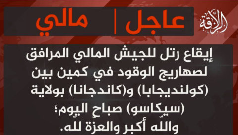
On Oct. 17, JNIM claimed via ChirpWire to have ambushed a fuel convoy between the towns of Kolondieba and Kidiana in the Sikasso region. NASA FIRMS data corroborated this claim, showing heat signatures along this road consistent with fire activity.

JNIM claim.

Bellingcat verified the location of the attack through satellite imagery captured on Oct. 21, which shows 50 burnt tankers. Verified footage, geolocated to 10.82640, -6.67186, filmed by what appear to be fighters on motorcycles, shows a long line of burnt-out tankers, matching the satellite evidence.

On Oct. 21, another attack occurred near Sikasso. Although NASA FIRMS data did not detect a fire, Bellingcat geolocated footage (left) showing multiple destroyed tankers and what appears to be a dead body next to a weapon (graphic footage was blurred.) The location was verified by matching the distinctive three-towered structure seen in one of the videos (right) to 11.17092, -5.62559.

Satellite imagery from Oct. 25 shows more than 40 tankers destroyed at the site, matching those seen in the footage.

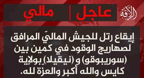
On Oct. 28, JNIM claimed a second ambush between the villages of Neguela and Soribougou, less than 70 km northwest of Bamako.

JNIM claim.

This was corroborated by NASA FIRMS data, which indicated fire activity in the area. A comparison of medium-resolution satellite imagery captured hours before the attack and on the day after the attack confirmed the location as: 12.90847, -8.60058, with smoke plumes rising from the site on Sep. 29.

On Oct. 30, Telegram channels linked to Russia’s Africa Corps circulated aerial footage showing fuel convoys traveling under military escort, supported by helicopters. One of these clips has been geolocated to the southern route toward Bamako. Other footage disseminated by state-aligned media has shown convoys arriving in the capital under heavy military protection, indicating that the junta is succeeding at getting some fuel through.

On Nov. 6, JNIM claimed an attack on fuel tankers between the cities of Zégoua and Sikasso in a statement posted to ChirpWire. Footage posted later to the group’s newly created media channel claimed to show the attack. NASA FIRMS did not detect fire activity in this region, but Bellingcat verified the location by matching the roadside structures seen in footage showing the aftermath of the attack to Google satellite imagery, geolocating it to: 11.12997, -5.60889.

A comparison of medium resolution imagery taken on Nov. 6 (prior to the attack) and Nov. 13 shows a large burn mark at this location, which is consistent with at least nine destroyed tankers seen in the footage and the reported timing of the attack.

Disruption of Daily Life

The fuel blockade has paralysed Mali. Food prices have soared, universities have suspended classes, and the US and the UK embassies have withdrawn non-essential staff. Social media videos verified by Bellingcat show people in Bamako queuing for fuel in lines stretching hundreds of meters and, in some cases, pushing their vehicles after pumps ran dry. A video verified from Oct. 23 shows a single fuel tanker in Bamako being followed by a large number of vehicles. The video’s caption suggests the motorists were hoping to obtain petrol.

The blockade’s broader effects can also be observed from space. NASA’s Black Marble nighttime imagery shows a noticeable dimming of Bamako’s lights when comparing May 29 and Oct. 25 – dates chosen outside of Mali’s rainy season to ensure clear skies for a reliable comparison. Mali relies on a “roughly equal mix of diesel and hydraulic sources”, meaning reduced fuel flows can cause diminished electricity availability and consumption, which is consistent with the dimming seen from space.

NASA Black Marble imagery from May 29 and Oct. 25 shows a difference between Bamako’s lights.

This investigation shows how open source information can help track a conflict that is often not possible with traditional reporting. Bellingcat has previously documented JNIM’s targeting of convoys in neighbouring Burkina Faso. By monitoring online content, geolocating footage and carrying out satellite analysis, it is possible to piece together a detailed view of a crisis that has left much of Mali in the dark.


Youri van der Weide and Miguel Ramalho contributed to this report.

Bellingcat is a non-profit and the ability to carry out our work is dependent on the kind support of individual donors. If you would like to support our work, you can do so here. You can also subscribe to our Patreon channel here. Subscribe to our Newsletter and follow us on Bluesky here and Mastodon here.

The post Mali Under Siege: Tracking the Fuel Blockade Crippling Bamako appeared first on bellingcat.

❌