A Bellingcat investigation has identified remnants of an AGM-88 series missile inside a three-storey apartment complex that was hit in Catia La Mar during the US military raid on Venezuela on Jan. 3, 2026 that reportedly killed at least one civilian.
According to the Venezuelan independent media outlet, El Pitazo, Rosa Gonzalez, 79, was killed in this airstrike in the city of Catia La Mar in La Guaira State, 30 km north of the capital Caracas. The attack reportedly left a second individual severely wounded.
Bellingcat asked the US Department of Defense to confirm our findings. However, they stated that “a Battle Damage Assessment is ongoing”. We also reached out to the Department of State but they did not respond to our questions at the time of publication.
The Jan. 3 US attack on Venezuela targeted multiple locations across the country, including military installations and areas within and around the capital, Caracas. US military helicopters, jets and drones provided cover for an assault force that landed at Fort Tiuna, the largest military complex in Caracas; captured President Nicolas Maduro and First Lady Cilia Flores, and flew them out of the country.
About 75 people, including civilians, were killed in the operation, US officials familiar with the matter told the Washington Post. Among the military fatalities were 32 Cuban and 21 Venezuelan soldiers, according to various media reports.
According to El Pitazo, a second woman, Yohana Rodríguez Sierra, 45, was killed, and her daughter wounded, in other strikes at a communications station at Cerro El Volcán. Multiple residential houses were also reportedly destroyed in the nearby area of La Boyera.
The military operation in Caracas follows a series of attacks on alleged drug boats which have reportedly killed at least 114 in the Caribbean Sea and the Eastern Pacific Ocean.
Identifying the Munition
Bellingcat has found videos showing the aftermath of the Catia La Mar attack and remnants of the munition filmed at the location. The strike destroyed some exterior walls of one apartment complex and caused extensive damage to at least two apartments.
Left: Screenshot from a video showing the destroyed exterior walls of the apartment building. Source: LaTrIncHEra/Instagram. Right: Screenshot from a video filmed inside the apartment complex showing an extensive fragmentation pattern on a neighbouring building. Source: Carlos Marea/Instagram.
Bellingcat geolocated the apartment complex to an area in Catia La Mar about 30 km north of Caracas (10.592796, -67.037721) and approximately 500 m east of a targeted air defence storage inside a military facility.
Top: Panoramic composite showing the damaged building hit in the strike. Credit: Youri van der Weide/Bellingcat. Bottom: Location where the residential building was hit in Catia La Mar, La Guaira, Venezuela. Source: Airbus/Google Earth.
Screenshot showing what appears to be weapon system remnants found at the apartment complex that was struck. Source: Carlos Marea/Instagram.
One video also reveals remnants of a munition. According to an analysis of visual evidence by Bellingcat, the remnants appear to show an AGM-88 series missile.
Another remnant of the AGM-88 series missile appears in a video published by Euronews. This remnant is a BSU-60 tail fin, that according to an analyst note on the Open Source Munitions Portal (OSMP), is used exclusively with the AGM-88 series missile.
The AGM-88 HARM/AARGM series are American-produced air-to-surface missiles that are designed to hit ground-based radar-emitting targets, such as air defence systems like the Buk-M2E used by Venezuela’s military, with several of them destroyed during the US military raid.
“Venezuela does not operate the AGM-88 HARM. Its F-16 acquisition occurred in 1983, when the US wouldn’t release anti-radiation tech to the region,” Dr Andrei Serbin Pont, International Analyst and President of the Regional Coordinating Centre for Economic and Social Investigations, CRIES, told Bellingcat. Later Israeli upgrades added guided munitions/AAMs, not ARMs, he said.
US Navy aircraft were photographed in the region with AGM-88E AARGM missiles in the weeks before the operation. Chairman of the Joint Chiefs of Staff, General Caine, stated that jets of this type, designed to suppress and destroy air defences, took part in the operation.
Left: US Navy E/A-18 equipped with an AGM-88E AARGM missile photographed in Puerto Rico on Dec. 15. Source: Ricardo Arduengo/Reuters. Right: US Navy Jet aboard the USS Gerald R. Ford, equipped with an AGM-88E AARGM missile on Dec. 22. Source: Seaman Abigail Reyes/DVIDS.
Air Defence Systems Targeted
The US struck several air defence systems across Venezuela as part of the operation, with Buk-M2E launchers being destroyed at La Guaira Port, and the Higuerote and La Carlota airbases. Satellite imagery from Vantor shows that the area near a BuK-M2E storage building at Fort Guaicaipuro was also struck, but no air defence systems can clearly be seen.
According to satellite imagery, Buk-M2E launchers appear to have been stored at the military base approximately 500m from the residential building that was hit.
Aug. 19, 2025, Airbus Satellite imagery of the site showing vehicles outside the buildings, including two Buk-M2Es with missiles loaded. Source: Airbus via Google Earth.
Bellingcat was not able to determine what caused the missile to strike the apartment building or if Buk-2ME launchers at Catia La Mar or a different system were the intended target.
The AARGM variant is capable of having designated missile “impact zones” and “avoidance zones” programmed to determine where the missile can or can’t impact when used on missions, a feature added to “prevent collateral damage”.
Bellingcat asked the US Department of Defense if any weapons used in the operation transmitted a weapons impact assessment or other data that indicated they hit an unintended or civilian location. They said that a Battle Damage Assessment is ongoing.
Carlos Gonzales, Giancarlo Fiorella, Jake Godin, Trevor Ball and Youri van der Weide contributed to this report.
Bellingcat is a non-profit and the ability to carry out our work is dependent on the kind support of individual donors. If you would like to support our work, you can do so here. You can also subscribe to our Patreon channel here. Subscribe to our Newsletter and follow us on Twitter here and Mastodon here.
Warning: Contains written descriptions of extreme violence including murder. All graphic footage has been omitted.
A Bellingcat investigation has identified and verified the exact location of a mass killing of more than 80 people that took place near Al Fashir during the recent siege and takeover of the Sudanese city by the paramilitary Rapid Support Forces (RSF). More than a dozen videos which have emerged online since Oct. 27 were analysed, some filmed by fighters wearing what appears to be RSF insignia, showing the events and their aftermath.
RSF fighter filming himself at the scene with visible shoulder-patch insignia. Bellingcat blurred the face and bodies in the background. Credit: X/Himma0099
Al Fashir, the capital of North Darfur, was the last major stronghold of the Sudanese military in the region and a refuge for people fleeing nearby villages and towns. The city, considered a strategic military location near the southwestern border leading to Chad and South Sudan, fell last week after more than 500 days under RSF siege. The RSF, which has been fighting Sudan’s military for control over the country, killed at least 1,500 people during the takeover, according to the Sudan Doctors Network.
A Mass Killing Outside the City
Open source evidence reviewed by Bellingcat showed that people attempting to flee Al Fashir were killed by men, some of whom appeared to be wearing RSF uniforms. The RSF had earlier pledged to remain “firmly committed to protect the civilians” and “not tolerate any attempts to exploit their lives or tamper with their security.”
Footage posted on social media showed a mass killing more than seven kilometres outside the city, where the fleeing convoy had encountered an earthen berm encircling Al Fashir. The berm and an accompanying trench were built by the RSF during the siege. Satellite imagery indicates that the section to the north-west of the city, where the mass killing took place, was constructed throughout August.
Satellite imagery of Oct. 27, showing the berm and trench dug around Al Fashir, checkpoints for roads leaving the city and the location of the mass killing. Satellite image credit: Planet Labs PBC
Bellingcat analysed more than a dozen videos. Given the extreme violence visible in much of the footage, only material that was not explicitly graphic has been included in this report. Some of the videos filmed at this location have also been geolocated by the Centre for Information Resilience and others.
Cross-referencing the different camera angles in the videos made it possible to map the exact location of the killings to a single location: 13.71340, 25.27854. In satellite imagery, clusters of dark shapes around the vehicles north of the berm correspond to the locations of bodies identified in verified videos from the scene.
Satellite imagery showing the convoy of burned vehicles and clusters of bodies by the berm, with corresponding screengrabs of videos geolocated to locations around the site. Satellite image credit: Vantor
In total, the video footage showed more than 80 bodies lying beside damaged and burning vehicles along the berm, inside the adjacent trench and across the surrounding area. More than two dozen destroyed vehicles were also identified.
Support Bellingcat
Your donations directly contribute to our ability to publish groundbreaking investigations and uncover wrongdoing around the world.
In one video, filmed early on in the attack, fighters in what appear to be RSF uniforms are seen taking cover behind a vehicle as gunfire is heard. One fighter can be seen closing in on the burning convoy and aiming his weapon.
However, in later videos filmed by the fighters showing the aftermath of the attack, none of the casualties visible appeared to be in possession of weapons; almost all appeared to be dressed in civilian clothing and several were women. Of the more than 80 casualties visible in various videos, a couple can be seen wearing what appears to be dark, military-style clothing, and one can be seen lying next to a belt of ammunition. Although, it is unclear who the belt belonged to.
The arrangement of destroyed vehicles and groups of bodies in the videos matched what was visible in satellite imagery. Moreover, tyre tracks visible in the sand appeared to link the mass killing site with the checkpoints along the sand berm. Fresh marks appeared on satellite images after Oct. 27., the day of the RSF’s complete takeover of Al Fashir.
Panorama of video footage taken at the site. The burnt vehicles in the background could also be identified on satellite imagery. Video: x.com/hodajannat24
A RSF commander known as Abu Lulu, identified in the videos by his distinctive white scarf, appeared in at least three videos from the scene. The commander has previously been featured in social media footage from the conflict. On Oct. 31, TikTok removed a profile believed to be linked to him.
In one video, geolocated by Bellingcat to the far side of the berm, the commander can be seen and heard taunting a group of 10 male captives sitting lined up on the ground, forcing them to praise the RSF and denigrate the military before they are shot.
Screenshots of the video showing RSF commander Abu Lulu talking to the 10 male captives before they were shot. Distinct features in the background of the video allowed geolocation of the scene. Satellite image credit: Vantor Video credit: X/Sudan_tweet
In another video filmed to the west of the convoy, Abu Lulu can be heard questioning a wounded man lying on the ground, threatening sexual violence before shooting him at point-blank range. In a third video filmed meters away, the same commander can be seen standing among a number of motionless bodies as he repeatedly fires into them.
In several other videos, one fleeing vehicle appears to have crossed the berm before becoming stuck in the trench on the far side. In one of these videos, filmed from inside the trench, a fighter can be seen firing into a group of motionless bodies on the ground next to the car, while others film and celebrate.
UN Investigation Points to a Pattern
Morris Tidball-Binz, the UN Special Rapporteur on extrajudicial, summary or arbitrary executions, told Bellingcat that “if the images were genuine”, these were “unlawful killings under International Human Rights Law, International Humanitarian Law (IHL) and International Criminal Law.”
“Under the former they correspond to extrajudicial or arbitrary executions; under IHL they correspond to war crimes and under the latter they may amount to crimes against humanity in view of the number of victims and the seemingly planned and systematic nature of the killings,” he said.
Subscribe to the Bellingcat newsletter
Subscribe to our newsletter for first access to our published content and events that our staff and contributors are involved with, including interviews and training workshops.
Tidball-Binz added that he was not aware of any steps taken by RSF command or relevant authorities to investigate these incidents or hold those responsible accountable. “So far impunity has prevailed,” he stated via email.
Footage from Oct. 30. shows Abu Lulu in RSF custody, being transported under heavy guard and later incarcerated in Shala Prison on the western edge of the city. The RSF announced an investigation into “violations” committed by fighters following the capture of Al Fashir.
Other open source data also documented evidence of atrocities within the city itself. In a chapter of a detailed report entitled “evidence of mass killings”, satellite imagery analysis by Yale’s Humanitarian Research Lab from Oct. 27 found what it said were “objects consistent with the size of human bodies on the ground near RSF vehicles” and “instances of reddish earth discoloration”.
The UN Security Council condemned the assault by the RSF on Al Fashir and “its devastating impact on the civilian population.”
The UN Fact-Finding Mission on Sudan expressed “grave alarm at escalating atrocities” detailing “a devastating pattern of atrocities by both warring parties” that include “war crimes of violence to life and person”. The mission’s initial findings pointed to “a deliberate pattern of ethnically targeted executions of unarmed civilians, assaults, sexual violence, widespread looting and destruction of vital infrastructure, and mass forced displacement”.
Carlos Gonzales, Jake Godin and Logan Williams contributed to this report.
Bellingcat is a non-profit and the ability to carry out our work is dependent on the kind support of individual donors. If you would like to support our work, you can do so here. You can also subscribe to our Patreon channel here. Subscribe to our Newsletter and follow us on Bluesky here and Mastodon here.
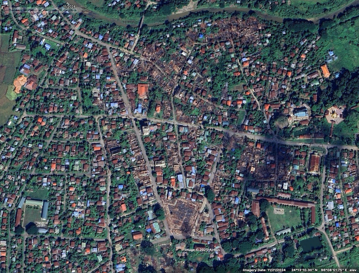
Bellingcat has identified at least 22 villages damaged by airstrikes in Myanmar, despite a temporary ceasefire declared by the State Administrative Control (SAC) or the military junta from April 2 to 22 following a 7.7 magnitude earthquake that hit the country on March 28. The ceasefire has been extended to April 30.
The earthquake’s epicentre was recorded just 16km northwest of Mandalay, the second-largest city in Myanmar, and it struck just before 1pm local time. More than 3,000 people died and aid groups report that over 17 million people living in earthquake-affected areas are in urgent need of food, water, shelter and healthcare.
The country, which has already been devastated by four years of civil war, continues to be hit with multiple aftershocks. The SAC, ruling Myanmar since seizing power from the democratically elected government in 2021, declared a temporary pause to fighting only after the main opposition coalition announced one – except in the case of defensive actions.
Bellingcat has geolocated at least 19 villages damaged in military assaults during the first 20 days of the ceasefire. Two of them were identified from ground reporting. Three additional villages were damaged after the earthquake but before the ceasefire – bringing the total to 22 villages.
The airstrikes targeted civilian areas in territory held by rebel forces and territory where the junta is fighting to regain control. The villages damaged after the ceasefire were geolocated by cross-referencing our findings with NASA FIRMS or satellite imagery alongside local and other media sources.
Villages bombed since the earthquake on March 28; the epicentre is marked in black, yellow and red
“It’s quite clear that only the military can do airstrikes. The rebels don’t have aircrafts,” Aye Chan Naing, co-founder and editor-in-chief of Democratic Voice of Burma (DVB), one of Myanmar’s largest independent media organisations, told Bellingcat.
Lacking jets or fighter planes, resistance groups heavily rely on commercial drones “improvised into sort of military use,” Naing said.
Targeting and scaring civilians is part of the military’s strategy, he explained. “If you support the rebels, then you know we [the military] are going to burn the village.”
“At a moment when the sole focus should be on ensuring humanitarian aid gets to disaster zones, the military is instead launching attacks,” said UN Human Rights Office spokesperson Ravina Shamdasani on April 11.
“Since the earthquake, military forces have reportedly carried out over 120 attacks – more than half of them after their declared ceasefire was due to have gone into effect on 2 April,” she told journalists.
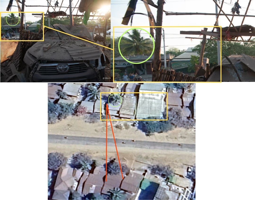
According to local media reports, the Myanmar military carried out an aerial attack just hours after the earthquake struck. Anti-junta armed group TNLA claimed that the military bombed Nawng Len village, approximately 120km from the earthquake’s epicentre in the eastern Shan State. Seven members of a TNLA-aligned ethnic armed organisation (EAO) were reportedly killed in the attack.
We were not able to independently confirm the airstrike, but we were able to geolocate images of several damaged buildings, to a location in the north of the village. The intact buildings can be seen on Google Earth imagery in late January.
The military junta did not respond to Bellingcat’s request for comment.
Attacks in Worst-Affected Earthquake Areas
Out of the 22 villages we identified, 14 of them are in either Sagaing or Mandalay, which were some of the worst affected areas by the earthquake. Large parts of both regions are located in central Myanmar, where a lot of townships are either contested or under junta control.
The military tries to cut the rebels’ survival pipeline, Naing told Bellingcat.
“They understand that the rebels cannot survive without civilians because that’s where they get food and maybe tax money,” he said.
Since the rebels don’t have permanent bases, members are difficult to locate. While drones might strike and kill a few individuals, it’s much easier for the army to identify and target areas where civilians live, Naing added.
On April 9, twenty people were reportedly killed in an airstrike in Nan Khan in Sagaing’s Wuntho Township. We were able to geolocate images of damaged buildings to the coordinates 23.9983922,95.8881422.
Just days before this attack, on April 6, Thone Pan Hla in Chaung-U Township was reportedly attacked in an airstrike, killing three members of a family. “The motivation for such an attack on a village of melon farmers is difficult to understand. It seems to be an effort to terrorise a civilian population that strongly supports the anti-regime National Unity Government (NUG) and its armed rebel PDF wing,” reported The Times newspaper. NUG is the country’s parallel government in exile, elected democratically and ousted in the 2021 coup.
About 25km northeast of Thone Pan Hla is the village of Ngar Shan also in Chaung-U Township. Local news outlets reported that the village was burned down by the junta, just days after the earthquake. While we weren’t able to geolocate specific images or independently confirm the cause of the fire, thermal hotspots were detected at the site on March 31. This lines up with the timeline and reports of 170 houses being burned in Ngar Shan on April 1 local time.
Images of the destruction shared on Facebook show the village in ruins. However, NASA’s Fire Information for Resource Management System, FIRMS, detects thermal hotspots in the entire village in the early hours of that day.
Source: NASA FIRMS, March 31, 2025 UTC
A false-colour infrared map from Sentinel Hub’s Copernicus platform also reveals signs of destruction in the village. Though commonly used to assess vegetation health, this type of imagery shows plant-covered areas in deep red, while cities and exposed ground are grey or tan, and water appears blue or black. Following the attack, exposed ground, indicative of possible damage, can be seen primarily in the northwest of the village.
Source: Sentinel Hub’s Copernicus platform
Chaung-U Township is located in the southern Sagaing region, where the geography poses challenges for resistance armies.
“Unlike ethnic resistance groups along Myanmar’s borders, or those in northern Sagaing near India, the resistance forces in southern Sagaing do not have foreign borders across which they can attempt to retreat,” wrote Centre for Information Resilience’s Myanmar Witness in a December 2024 report.
Sagaing remains an epicentre for violence with a strong resistance presence due to the region’s strategic importance. A state of emergency was declared in the state following the quake.
Repeated Bombings in Lost Territories
Another region of strategic importance is Mandalay where the Central Military Command is located in the Mandalay Palace, reported to have been damaged in the earthquake. Mandalay is also a logistical hub in Myanmar’s heartland, and since late last year, the SAC has been trying to retake townships it has lost there.
Two of those townships are Thabeikkyin and Singu. Both were attacked during the ceasefire.
On April 19, the Myanmar military reportedly carried out an airstrike on the village of Yae Htwet in Thabeikkyin Township. The attack killed at least 27 people, according to the BBC. The report added that pro-military Telegram channels claimed the attack targeted PDF camps, the armed wing of the anti-regime National Unity Government.
Just a day earlier, 13 people were reportedly killed in an attack on Leik Kya village, located 3km north of Yae Htwet.
A separate aerial attack was reportedly carried out over a village in Thabeikkyin, killing two people. It took place on April 13 in Chaung Gyi along the highway running through the village. We were able to identify distinct features of the roof of buildings across the street from the attack and, along with the location of trees, match satellite images of the area.
Bellingcat also geolocated a school (here: 22.689505, 96.016978) in Singu Township, the site of a reported airstrike in Kyi Tauk Pau village that injured six people.
Destruction of Schools and Religious Sites
The junta has a track record of targeting schools. According to a tally by Radio Free Asia last November, nearly 200 schools were hit by airstrikes since the 2021 military coup in regions and states which have seen fighting by resistance forces opposing junta rule.
A school in Sagaing’s Shwebo Township was reportedly bombed during the ceasefire on April 20, killing two people, including a pregnant woman. According to DVB, Shwebo Township People’s Administration, a local anti-junta governance body, said displaced people were taking shelter in the school.
Bellingcat found four schools and seven religious sites – monasteries and churches – damaged in recent attacks.
Peter Bouckaert of the human rights and advocacy group Fortify Rights called the attacks on churches and monasteries that could be hosting people displaced by the earthquake “a great violation of the laws of war”.
“These are protected sites under international humanitarian law. They are direct deliberate attacks on these protected institutions,” he told Bellingcat.
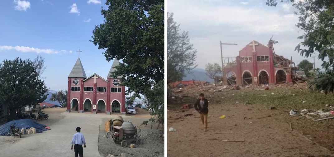
The junta has a history of attacking religious sites. During the ceasefire, a Baptist church was bombed in Mindat in the neighbouring Chin State, where several armed opposition groups have emerged since 2021. While there were no reported casualties at the church, six people were killed in the attack on the town.
Mindat was taken over by resistance forces last year amid reports of hundreds of homes destroyed by alleged junta shelling, arson, and airstrikes. A lot of this damage is now visible on Google Maps’ updated imagery from January 2025.
Several churches in Chin State have been damaged in the past few years, Myanmar Witness had found in 2023. It is the only Christian-majority state in Buddhist-majority Myanmar.
Battle for Control of Town Rages Amid Ceasefire
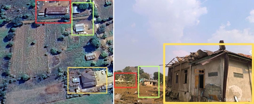
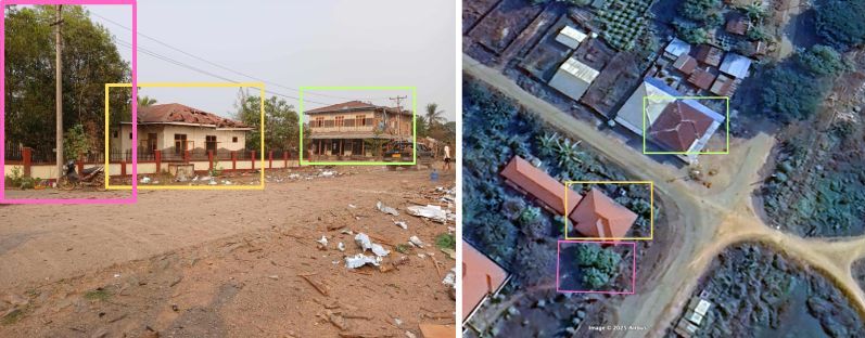
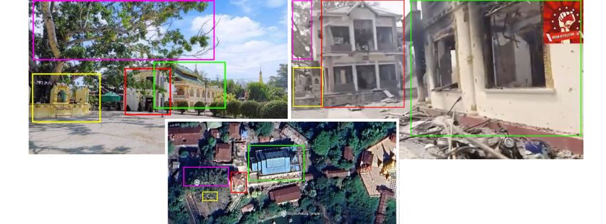
Indaw is a small town close to the border with Kachin, a state partly controlled by the Kachin Independence Army (KIA)-led resistance forces. Indaw was reportedly bombed on April 1 when it was still under the junta’s control. According to local accounts, two people were killed and eight others injured. A monastery was damaged in the attack. We were able to geolocate the images of the aftermath by comparing old pictures and satellite images of the monastery with structures still standing after the recent attack.
The destruction on April 1 was just one of the many assaults the town has witnessed since resistance forces launched an offensive in August last year. The junta’s reported airstrikes against the resistance displaced hundreds of people, and many others fled.
Despite the ceasefire, on April 8, resistance forces captured Indaw after months of fighting. However, the junta has continued to carry out airstrikes in civilian areas, according to reports. As Richard Horsey, Senior Adviser on Myanmar at Crisis Group, previously told Bellingcat, the junta often bombs areas it has lost so people have nothing left to return to.
Images show that large parts of Indaw were destroyed last year. Source: Google Earth Pro Imagery
Attacks During Burmese New Year
The military regime reportedly carried out airstrikes on monasteries over the four-day Thingyan or Burmese New Year festival from April 13 to 16. According to data compiled by an independent news site, The Irrawaddy, at least 23 civilians were killed in these attacks.
In one of the monastery attacks, six people were reportedly killed and 20 others injured. Bellingcat geolocated the aftermath of the reported strike. This was in Kan Ni village in Kawkareik Township in Kayin, one of the southernmost states of the country.
The Myanmar military has now extended the ceasefire to April 30 in a move to “expedite relief and rebuilding efforts”, but reports say that aid is being restricted. “The SAC is weaponising humanitarian assistance,” Surachanee Sriyai, interim director at the Center for Sustainable Humanitarian Action to Displaced Ethnic Communities, told Bellingcat, explaining that aid is not reaching areas that aren’t under the SAC’s control. An analysis by the BBC in November last year reported that the military only has full control of 21% of Myanmar’s territory.
Sriyai noted that while the earthquake has drawn some attention to Myanmar, the country has already been in critical need of aid due to the prolonged armed conflict. Meanwhile, bombings persist even during the extended ceasefire period.
Members of Bellingcat’s Global Authentication Project, including Afton Knox, Nicole Kiess, Stéphanie Ladel, Timothy B and Max F. Wan contributed research to this piece.Interactive map by Miguel Ramalho.
Bellingcat is a non-profit and the ability to carry out our work is dependent on the kind support of individual donors. If you would like to support our work, you can do so here. You can also subscribe to our Patreon channel here. Subscribe to our Newsletter and follow us on Bluesky here, Instagram here and YouTube here.