❌

Visualização de leitura

How Online Maps Lay Bare the US Military Bases Targeted by Iran

Sign up here to receive Bellingcat’s biggest investigations by email as soon as they are published. Become a member and support our work here.

In September, CBS News obtained new images of the aftermath of attacks on US bases in the Middle East from active service members. One told the news channel: “This is major damage to our bases that hasn’t been communicated to the American public. “We’re standing there with our eyes closed getting punched in the face,” they added.

While reports have detailed how Iran used Russian intelligence, including satellite imagery, to identify US troops, ships and aircraft, Bellingcat found that publicly available mapping platforms also reveal detailed and potentially sensitive information about US military bases in the Middle East. 

Google Maps and other online mapping services contain dozens of labels identifying facilities including headquarters, accommodation, gyms and fuel points. Publicly available photographs and videos, including material published by the US military, provide further details about how these facilities are used.

Experts told Bellingcat that such information could have helped inform Iranian targeting decisions by revealing where personnel gather and how bases operate. However, they cautioned that Iran would also have had access to other sources of intelligence. Reporting from Reuters earlier this year also highlighted how US officials believed commercially available location data was being used to target US troops in war zones.

The bases examined by Bellingcat are not secret and have operated for years in a region where US forces maintained a strong sense of security. Joseph Jarnecki, a research fellow at the Royal United Services Institute, said the US had been able to maintain aerial superiority and was understood to have significant air defence capabilities, but that Iran’s missile and drone campaign has undermined both assumptions. 

Iranian strikes have damaged at least 20 US military sites across Qatar, Bahrain, the United Arab Emirates (UAE), Jordan, Kuwait, Iraq and Saudi Arabia since the conflict began in February this year.

Governments can request that Google blur or remove sensitive information from its services and Google publishes data on government requests for content removal.

Bellingcat contacted the US Department of Defense who asked us to reach out to CENTCOM about the details in this story. We also contacted Google. However, we did not receive responses to questions from these respondents before publication.

We examined four of the largest and most heavily affected US military installations by Iran’s missile and drone campaign: Camp Buehring and Camp Arifjan in Kuwait, Muwaffaq Salti Air Base in Jordan and Al Udeid Air Base in Qatar. At each one, we found publicly available Google Maps information providing details about facilities inside the bases and how they are used.
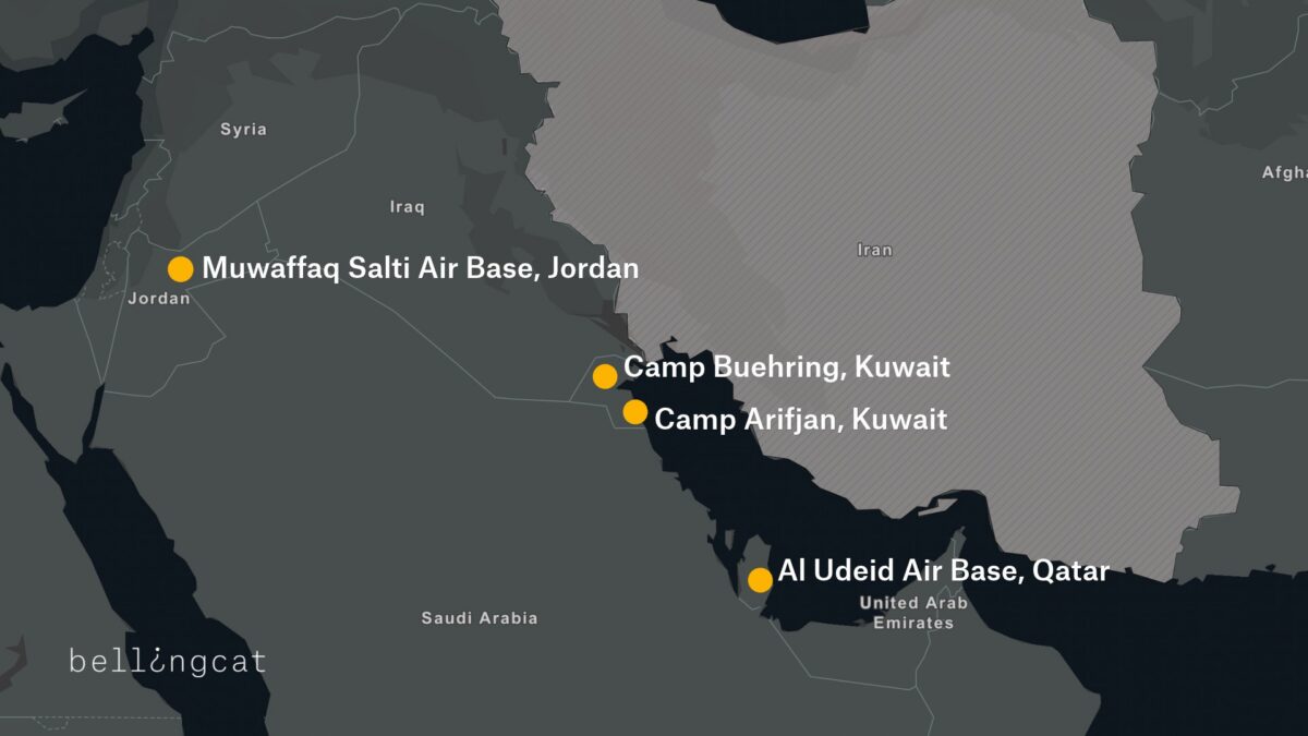
A map detailing four US bases that were attacked by Iran during 2026 conflict.

Camp Buehring

At Camp Buehring in Kuwait, Google Maps identifies what is labelled as the main headquarters building, as well as a gym and a self-help facility, all of which were among locations destroyed by recent Iranian strikes. In addition to Google Maps place markers there are dozens of reviews and user-uploaded photographs.
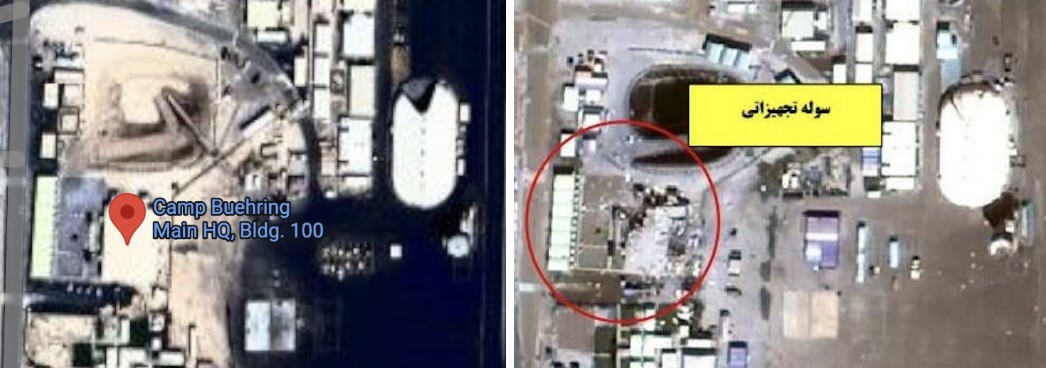
Left: Screengrab showing “Camp Beuhring Main HQ, Bldg. 100” Google Maps label. Right: Same building seen destroyed on satellite image published by Iran’s Tasnim news agency.

Bellingcat verified that this was a headquarters building by matching the flagpoles and layout in a photo published by the US military’s Defense Visual Information Distribution Service (DVIDS) showing soldiers posing in front of the  building to the Google Maps satellite image.
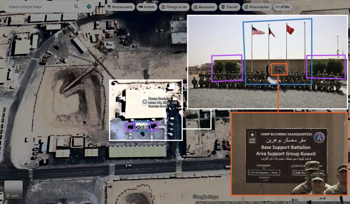
Geolocation diagram using dvids photo to verify Google Maps Buehring main headquarters location, confirming the accuracy of the Google Maps place marker.

We also identified details about one of the camp’s gyms, including the building’s layout and roof structure, as well as Google reviews that indicate when it is busiest.
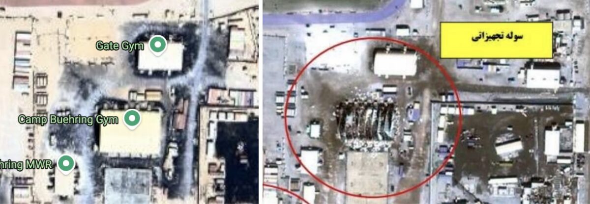
Left: Google Maps label showing “Camp Beuhring Gym” Right: Destroyed gym building on satellite image published by Iran’s Tasnim news agency on 6 April 2026.

Among the images published by CBS News in September was that of a heavily damaged tent-like structure with smoke rising from it. Bellingcat matched the location of this image to the above satellite imagery, verifying that it shows the gym building pinned on Google Maps.

⚡🚨 Exclusive images released showing damage to E-3 Sentry AWACS aircraft at Prince Sultan Air Base in Saudi Arabia, plus damage to US military camps Arifjan and Buehring in Kuwait from Iranian strikes. Images sent to CBS by active US military personnel. (IRIB News) https://t.co/1urA44f4xz


— Middle East Observer (@ME_Observer_) September 15, 2026
Left: Google Maps shows images of the gym’s interior and exterior. Right: Google Maps reviews indicate when the gym is busy (names blurred by Bellingcat).

A building labeled on Google as “DPW Self-Help Center” was also destroyed at Camp Buehring. Its Google Maps listing includes opening hours, and a photo posted by a Master Sergeant in 2017 labeled “My office in Kuwait” shows the interior of an office. Some of the notices on the walls inside the office are legible, including what appears to be a floor plan.
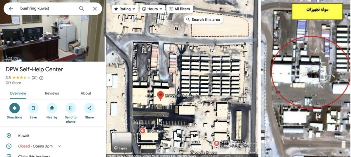
Left: Google maps “DPW Self-Help Center” listing. Right: Same building seen destroyed on a satellite image published by Iran’s Tasnim news agency on April 6, 2026.

A Google Maps placemark labelled “Transient Tent” identifies a large accommodation area, while another review includes a ground-level photograph of one of the tents. The dining facility can also be seen from the inside, including information regarding meal times.
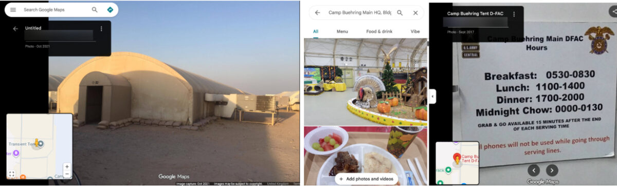
Left: Google image that appears to show an accommodation area. Right: Photos of the dining facility, including information on meal times (names blurred by Bellingcat).

William Goodhind of Contested Ground, a visual forensics consultancy that uses OSINT and satellite imagery to analyse military sites, said the information available on Google Maps could reveal “the camp’s layout, the division between secure and non-secure areas, confirms likely accommodation areas, and shows day/time periods of low and high activity.”

Camp Arifjan

A satellite image of Kuwait’s Camp Arifjan, captured by Planet on March 4, 2026 and published by the The Washington Post, shows damage to numerous structures at the base. Bellingcat compared the image with publicly available mapping data to identify two damaged facilities.

A Google Maps listing for a lodging facility labelled “TPE FOR ARIFJAN” includes a soldier’s review discussing room reservations, accommodation shortages and cleaning schedules, indicating that the building was used for military housing. Although Google’s satellite imagery of the base is blurred, the facility is visible in unblurred Bing Maps imagery using coordinates obtained from its Google Maps listing. The satellite image published by The Washington Post shows heavy damage to the facility.
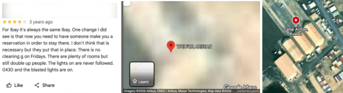
Left and centre: Blurred Google Maps satellite image with Google review (name blurred by Bellingcat). Right: Unblurred Bing maps satellite image showing the same location.

A “24hr Fuel Point” tagged on Google Maps is also blurred, but when the coordinates are copied and pasted into Bing Maps a clear satellite image of the fuel station appears. This facility is also seen destroyed on the satellite imagery published by The Washington Post.
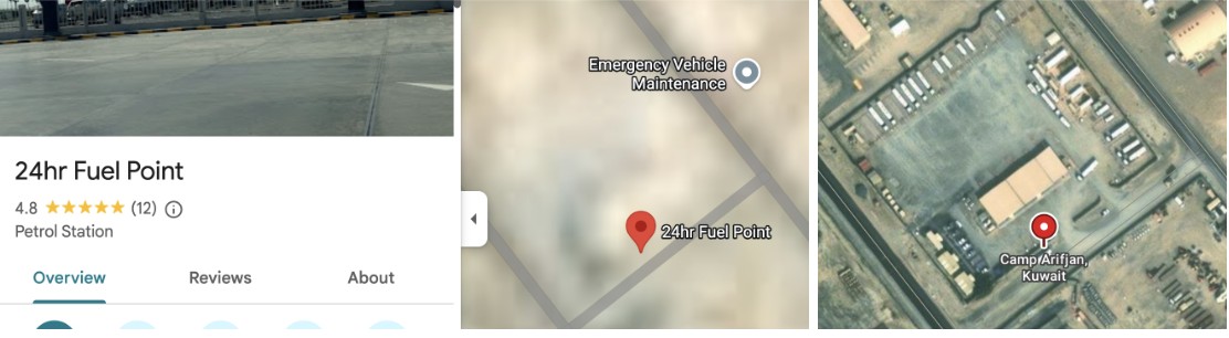
Left and centre: Blurred Google Maps satellite image with Google review. Right: Unblurred Bing Maps satellite image.

Bellingcat contacted Microsoft to ask why the facility was not blurred out in the Bing Maps service. A spokesperson said: “When an entity requests removal from visibility on Bing Maps, we work through our process and act accordingly.”

Muwaffaq Salti Air Base

Three US service members were killed in Iranian ballistic missile strikes on Muwaffaq Salti Air Base in Jordan on July 17, 2026. The strikes appear to have caused extensive damage to a barracks in the north of the base, with satellite imagery released by Iran showing at least 20 structures destroyed.

Less than 40 metres from the nearest destroyed structure, and within the same living quarters area, Google Maps reveals the location of an “Airman’s Attic”. These are volunteer-run thrift shops for US Air Force personnel. 

A five-star review posted last year by a soldier includes a ground-level image of the facility, showing uniform drop-off points and fortifications along the perimeter. The listing provides information about the area’s use, while photographs of the shop’s exterior make it possible to match the satellite imagery to the location on the ground.

A Sky News investigation also found that 80 percent of the runs shared publicly on the sporting app Strava at Muwaffaq Salti Air Base during the April ceasefire started or finished in this northern barracks.
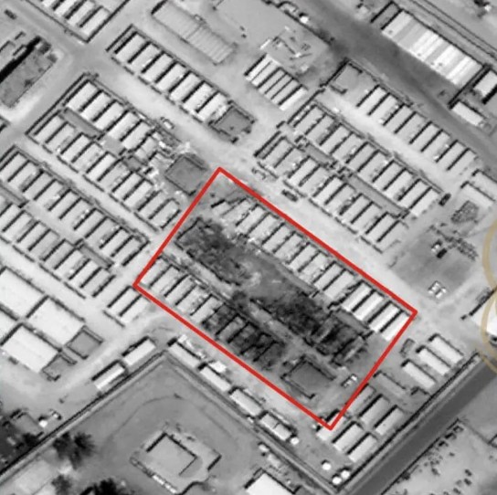
Satellite image showing damage, highlighted in red, published by Iran’s Fars News Agency.

Less than 100 meters from the destroyed area, “LSA DFAC” is pinned on Google maps. “DFAC” is the standard US military acronym for “dining facility”, according to Stars and Stripes. Several Google reviews also discuss the steak being served in this location.
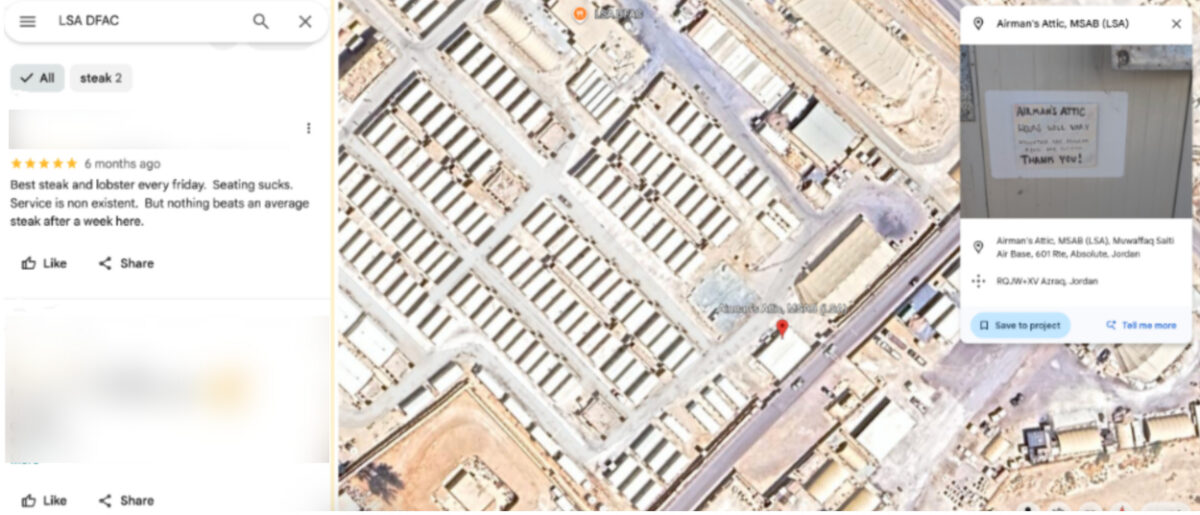
Left: Google reviews for the dining facility (names blurred by Bellingcat). Right: Google Earth satellite image with the Airman’s Attic and dining facility visible in the area targeted by Iran.

Al Udeid Air Base

Similar mapping information is available for Al Udeid Air Base in Qatar, the largest US military installation in the Middle East. 

The base appears unblurred on Google Maps and entries on the platform identify the functions of numerous buildings. These include lodging facilities, which videos and reviews indicate are used by US Air Force crews and show the interior layout of the facility.
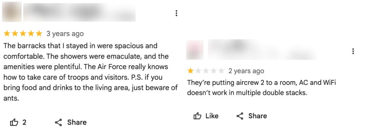
Google reviews for “Al Udeid Lodging” indicate the presence of US Air Force crews (names blurred by Bellingcat).

Meanwhile, Russia’s Yandex Maps details the site of two cinemas, a bar and a school on the base. This appears to match information provided on Google Maps.

While Al Udeid Air Base was damaged during Iranian attacks earlier this year, the areas that were struck do not appear to be among those listed on Google. 

Business Insider reported that a geodesic dome that housed secure communications equipment was hit in the strikes. ABC News detailed how another building had been damaged near the centre of the base. Google Maps shows a large warehouse-like structure at the location where ABC News reported this strike.

A New Reality in the Middle East

Former US Air Force targeting specialist Wes J. Bryant said the problem facing US bases in the Middle East reflected a broader assumption within the military that bases in allied countries were safe from serious attack. He said the belief that these were rear-area bases where “nothing’s going to happen out here” was a fundamental miscalculation, and that the Google Maps issue was an example of the military failing to account for that vulnerability.

Matthew Savill, Director of Military Sciences at the Royal United Services Institute, said Western militaries do not have consistent policies governing what information can be publicly posted about sensitive sites. He said the issue needs to be considered before a conflict begins, rather than when attacks are already underway. “The start point should be, can we enforce operational security discipline?” Savill pointed to restrictions already in place at some UK military facilities, including Faslane, a naval base that houses the UK’s nuclear submarines, where he said personnel are not permitted to use mobile phones on site.

Savill told Bellingcat that the different pieces of data available on Google Maps, even if outdated, provided a “pattern of life” about US bases in the Middle East. But he added that the use of Google to help with the military targeting of Western bases is not new, saying he encountered the issue while deployed to Iraq more than 20 years ago.

“When I was in Iraq, we knew for a fact that insurgents and militants had been using commercial imagery, including Google Earth, to try and map our bases,” he said. “We have known for more than 20 years that there is a vulnerability that if you don’t stop the collection and layering of data early on, that your bases can be heavily mapped.” 

The use of open-source information to support military targeting has been documented in Ukraine. In 2022, Foreign Policy detailed how Ukrainian private intelligence company Molfar used photographs of Russian soldiers published by Russian media alongside Google Earth satellite imagery to identify their location. Molfar passed its findings to Ukrainian intelligence, and the site was subsequently struck by the Ukrainian military.

The security risks of publicly mapping military installations were recognised by the US military in 2008, when the Pentagon banned Google’s Street View from documenting the interiors of its bases. Since the Iran war started, US military commanders have also warned service members about posting photographs and videos from bases after Iranian attacks, cautioning that such footage could help Iran assess the effects of its strikes.

Iranian attacks have forced US personnel to evacuate many additional locations that were deemed too vulnerable to further strikes. 

In total, 23 US service members have been killed and 865 wounded in the US-Iran war, according to the Pentagon.


Bellingcat’s Jake Godin, Charlotte Maher and Merel Zoet contributed to this report.

Bellingcat is a non-profit and the ability to carry out our work is dependent on the kind support of individual donors. If you would like to support our work, you can do so here. You can also subscribe to our Newsletter and follow us on Bluesky here, Instagram here, Reddit here and YouTube here.

The post How Online Maps Lay Bare the US Military Bases Targeted by Iran appeared first on bellingcat.

Two Waves of Bombing: New Videos Reveal Further Details About Iran School Strike

Bellingcat has geolocated and verified two new videos showing the deadly strikes that hit an Iranian Revolutionary Guard Corps (IRGC) compound as well as an adjacent school in the city of Minab in late February.

The new videos were released by Iran’s Ministry of Foreign Affairs and show multiple missiles hitting the complex. 

One of the new videos shows the area around the school being struck while the other shows a nearby IRGC clinic and two buildings within the IRGC facility being hit by Tomahawk missiles. 

Support Bellingcat

Your donations directly contribute to our ability to publish groundbreaking investigations and uncover wrongdoing around the world.

Visual and solar analysis of the videos appears to show there was a time gap between when each was filmed, suggesting that there were at least two waves of strikes carried out in the area. 

Applying the same solar analysis techniques to social media footage that showed the school after it had been hit indicates the school was impacted during the first wave of strikes.

Previous investigations by Bellingcat and other news organisations showed a US Tomahawk missile struck the IRGC facility on Feb. 28. 

The US is the only party to the conflict to possess Tomahawk missiles.

Media reports, including from the New York Times and Reuters, have since detailed that a preliminary investigation by the US military concluded it was likely a US strike that hit the Shajarah Tayyebeh elementary school.

According to Iranian media, at least 175 people were killed in the attack, including children.

Analysing New Minab Videos

The first video (video one) is filmed from just over 2.5 kilometres (1.5 miles) away from the IRGC base and shows at least 10 missiles impacting the area over a period of 50 seconds.

The first explosion is visible five seconds into the video. The area around where the school was located is struck at 14 seconds. This is the fourth explosion visible in the footage.

Another structure that was damaged in the strikes is situated approximately 100 metres away from the school in the same general area. It was therefore not possible to determine which exact structure was hit from this footage alone.

Screenshot of Video one showing 10 missiles striking the area. The fourth impact hits the area round the school (white box), seconds after the first three explosions. Annotation by Bellingcat. Source: Tasnim News.

The second new video (video two) was filmed approximately two kilometres southeast of the school, and is of a higher quality than video one. This video shows three Tomahawk missiles in the moments before impact.

Screenshots from Video two showing each Tomahawk missile before impact. Annotations added by Bellingcat. Source: Iran Ministry of Foreign Affairs.

Video two includes annotations and pauses when each Tomahawk appears on screen. 

A frame-by-frame analysis also shows what appear to be two minor visual glitches where some frames are transposed and annotations were added, highlighting when missiles can be seen.

The second impact seen in video two is the same as seen in footage released by Iranian media in early March, and previously reported on by Bellingcat and others, only from a different perspective.

Video two also only shows the southern part of the base, with its northern section not visible. The school is located on the northern edge of the base and is therefore not visible in video two.

Left: Tomahawk missile strike in footage previously published showing Tomahawk strike in Minab. Right: The same strike visible in Video two. Sources: Mehr News and Tasnim News.

Bellingcat asked the Iranian Ministry of Foreign Affairs why only part of the strike, as seen in video one, was released and if there was a longer version that may show further impacts. We did not receive a response before publication.

Bellingcat also asked the US Department of Defense whether it had any further information on the strike since its reported preliminary findings. It referred us to CENTCOM, which said: “We have nothing for you on this. The investigation is still ongoing.”

Geolocating the Videos

Bellingcat was able to geolocate and verify video one by tracing sightlines on satellite imagery to determine the camera’s location and identify objects such as buildings, trees and a water tower within the IRGC facility. 

According to this analysis, video one was most likely filmed from an electric substation southeast of the school.

Left: Screengrab from video one. The dashed vertical lines represent the intersection of planes of constant angle with the image plane. These planes connect the center of the camera and enable the selected elements to be geolocated. Right: annotated satellite imagery showing the corresponding perspective lines and the geolocated elements. The analysis allowed us to identify, geolocate buildings and locate the explosion points. Annotated by Bellingcat. Source: Tasnim News. Satellite Image: Google Earth/Airbus

Once all key elements were identified and geolocated, we analysed each explosion that can be seen in the footage. 

Fourteen seconds into video one, the fourth impact appears to hit the area immediately around the school, which was approximately 200 meters behind a water tower. 

While the school was walled off and outside the IRGC facility, the water tower and another building (situated between the school and the water tower) are located within it.

Due to the relatively small distance between the school and the other IRGC building (roughly 100m), it was not possible to determine what structure was hit at the moment of the strike visible in video one.

More information, such as obtaining the entire strike video sequence, would be needed to fully determine which structure was hit in this footage. However, social media footage captured at the scene does suggest that the school was hit around this time.

Left: Line of sight passing by the yellow building intersects the point of forth explosion from behind the IRGC water tower. Center: Direction of line of sight intersects school and passes close to a nearby IRGC building. Both buildings were damaged in the attack. Right: Satellite image showing both the school and IRGC building. More details would be needed to determine which of both buildings were hit in this video. Satellite image: Google Earth/Airbus

For video two, we stitched together a rough panorama of what could be seen in the footage. 

This made it possible to match up multiple buildings visible southeast of the IRGC base and school, while also building rough sightlines to show which part of the base was being filmed.

Annotated geolocation with Google Earth imagery showing key visual elements visible in the stitched panoramic from the end of Video two and their corresponding locations in satellite imagery. Source: Tasnim News. Satellite Image: Google Earth/Airbus/Maxar.

Bellingcat was able to narrow down the areas hit by the three missiles seen in video two by comparing it with the point of view of a short video released in early March, showing a Tomahawk hitting the complex, as well as with what could be seen in video one. Post-strike satellite imagery also helped confirm the buildings that were hit in the footage. 

We were thus able to determine that video two shows an IRGC clinic and two buildings within the IRGC compound being hit.

Left: Planet SkySat imagery of the IRGC Base, and the adjacent school and health clinic, collected March 04, 2026 after the strikes. Annotated by Bellingcat. Right: Screenshots of the three explosions in video two. Sources: Planet and Iran Ministry of Foreign Affairs

Time of the Strikes

The Iranian Ministry of Foreign Affairs has claimed that two waves of strikes occurred. 

Initial analysis did suggest that video one and two appeared to be filmed at different times as the strikes visible in each clip cannot be synced up. 

Solar data also gives clues as to the time each was taken, suggesting that there was a time gap of at least an hour between the strikes seen in the two videos.

According to the New York Times, the strikes were first reported on social media just after 11:30 am.

Solar data, derived by the direction of shadows visible in video one and simulated via the SunCalc platform, appears to indicate it was filmed between 10:30 and 11:30am.

Left: Screengrab from video one showing an object on a roof casting a shadow consistent with a time between 10:30-11:30 a.m on February 28 2026. Right: Solar data simulation center on the object. Source: Tasnim News, SunCalc.org

Analysing the shadows seen in the earlier March video using the same method, appears to show that it was filmed between 13:30 and 14:30. 

This would seem to indicate that video two and the earlier March video were likely filmed after video one.

Left: Screengrab from earlier March video showing rebars casting a shadow parallel to the building construction and consistent with a time between 13:30-14:30 on February 28 2026. Top Right: Solar data simulation center on the object. Bottom Right; Satellite image showing the shadow direction along the building line. Source: The Washington Post, SunCalc.org. Satellite Image: Google Earth Pro/Airbus

Solar data from a video posted to Telegram showing the smouldering school, and damage to the nearby IRGC building about 100m away, shows that it was recorded around the time of the first video.

Left: Screengrabs from a video released the day of the strikes, showing the destroyed school (blue), and damaged roof of the IRGC building about 100m away (red box). Inset: Planet SkySat imagery showing this building (red) and the school (blue). Right: The shadow cast by the bystander is consistent with a time between 11:00-12:00 on February 28 2026. Right: Solar data simulation centred on where the bystander was standing.. Sources: Mehr News, Planet, and SunCalc.

This, therefore, appears to confirm that the school was impacted before the wave of attacks seen in video two.

Iranian media previously released images of munition remnants they claim they recovered from the school. 

Bellingcat was not able to verify where the remnants were originally found, but was able to identify them as Tomahawk missile remnants. The New York Times also confirmed this identification by matching the contract number on a remnant to a contract for the Tomahawk missile.


Bellingcat’s Carlos Gonzales, Jake Godin and Trevor Ball contributed research to this article.

Bellingcat is a non-profit and the ability to carry out our work is dependent on the kind support of individual donors. If you would like to support our work, you can do so here. You can also subscribe to our Patreon channel here. Subscribe to our Newsletter and follow us on Bluesky here, Instagram here, Reddit here and YouTube here.

The post Two Waves of Bombing: New Videos Reveal Further Details About Iran School Strike appeared first on bellingcat.

Evidence Points to US Scattering Mines over Iranian Village

The US appears to have deployed the Gator Scatterable Mine system over Kafari, a village near Shiraz, in southern Iran overnight. Several people were killed according to Iranian media. 

Three experts told Bellingcat the munitions appeared to be air-delivered US-made Gator anti-tank mines. 

The US is the only participant in the Iran war known to possess Gator Scatterable Mines. 

Bellingcat asked the US Department of Defense whether it had dropped the mines overnight, but did not receive a response at time of publication.

Satellite Imagery showing the village where the mines were found in relation to an Iranian “missile city”. Source: Logan Williams / Bellingcat. Aerial imagery © 2026  Airbus, CNES / Airbus, Landsat / Copernicus, Maxar Technologies via Google Earth. Inset map © 2026 Mapcreator, OpenStreetMap.

Dr NR Jenzen-Jones, Director of Armament Research Services, told Bellingcat that the images appeared to show US-made anti-tank landmines. 

“These images show what appear to be American BLU-91/B scatterable anti-tank landmines. 

“The BLU-91/B is dispensed from the CBU-78/B or CBU-89/B air-delivered cargo bombs (cluster munitions). 

“The presence of square ‘aeroballistic adaptors’ indicates that the mines seen here were delivered by air. Similar mines can be dispensed from the vehicle- or helicopter-based Volcano system.”

Gator “SCATMINE” system. BLU-91/B pictured on the bottom left, BLU-92/B pictured on the bottom right. Source: Department of the Army. 

Amael Kotlarski, Weapons Team leader at Janes, also identified the mines as BLU-91/B ‘Gator’ anti-tank mines. Kotlarski told Bellingcat “the BLU-91/B is dispensed from either the US Air Force’s CBU-89/B (72 BLU-91/B and 22 BLU-92/B) or the US Navy’s CBU-78/B (45 BLU-91/B and 15 BLU-92/B).”

He elaborated that the BLU/92B is an anti-personnel mine, similar in appearance to a BLU/91B, though not identical.

“No BLU-92/B is observable in the photographic evidence presented so far. This could be that they have not been found, or that the dispensers were loaded solely with AT mines to help reduce the risk to civilians.”

BLU-91/B anti-tank mine posted by Iranian Media. Source: IRIB News.

Gator Scatterable Mines System

The Gator system is an air-delivered dispenser system or cargo bomb that distributes mines over an area. These dispensers contain a mixture of either 94 or 60 BLU-92/B anti-personnel and BLU-91/B anti-vehicle mines depending on which dispenser is used. These dispensers release the mines over an area of approximately 200 by 650 metres.  In the images reviewed by Bellingcat, it is not clear which dispenser was used, or how many dispensers were deployed.

Reference images of the BLU-92/B and BLU-91/B. These mines may or may not have the box-shaped “aeroballistic adaptor” attached to the circular mine when found. Source: Naval Explosive Ordnance
Technology Division via Bulletpicker.

Andro Mathewson, an independent open source analyst, who formerly worked at landmine-clearing NGO The HALO Trust, told Bellingcat the images showed BLU-91/B mines.

BLU-91/B mine found with an aeroballistic adaptor. Source: Tasnim News.

Some of the images of the mines posted by Iranian media show an aeroballistic adaptor. The aeroballistic adaptor is only present on the BLU-91/B and BLU-92/B, not on other mines within the US Family of Scatterable Mines (FASCAM), indicating that these were deployed from a Gator system aircraft dispenser.

BLU-91/B mine with a partially broken aeroballistic adaptor. Source: Tasnim News.

BLU-91/B and BLU-92/B Mines and Self-Destruct Features

Both BLU-91/B and BLU-92/B mines are activated two minutes after being deployed; however, a very small number can fail to properly arm and explode. These mines also have self-destruct features with a variable delay which means they may randomly explode hours or days after they are dispensed. They may also explode if disturbed. These features make them particularly dangerous.

The self-destruct can be set for 4 hours, 48 hours, or 15 days, but the mines may self-destruct before then.

So far, only visual evidence of magnetically influenced BLU-91/B anti-tank mines has been posted online, but these mines are usually deployed alongside the anti-personnel BLU-92/B. The BLU-92/B also deploys tripwires.

In addition to the self-destruct features, the BLU-92/B anti-personnel mines have an anti-handling device (AHD) that is intended to make the mine explode when disturbed. While BLU-91/B anti-tank mines do not have an anti-handling device (AHD), they “may detonate when moved, because the mine may sense a significant change from its original orientation.”

Amael Kotlarski of Janes told Bellingcat that “The mine will go off if subjected to significant movement.” This could explain local reports that a man was killed when he picked one up near his car. 

Characteristics of BLU-92/B and BLU-91/B scatterable mines. Source: Department of the Army.

Uniquely US Weapons

The US is the only participant in the war known to possess these mines. They were developed after the US stopped supplying arms to Iran. A review of Stockholm International Peace Research Institute’s (SIPRI) Arms Transfer Database, and US Major Arms Sales does not show any transfers of these mines to Israel.

Dr Jenzen-Jones also told Bellingcat that “Scatterable anti-tank landmines may have been employed to deny vehicles access to or from so-called ‘missile cities’. This could both prevent TELs [missile launch vehicles] from leaving, and limit efforts to re-establish access to facilities (for example, by preventing excavators from operating at collapsed entrances).”

Bellingcat geolocated some of the mines to the village of Kafari, Iran (coordinates 29.50544059, 52.48745447 and 29.50964897, 52.48920842). This video shows at least three mines approximately two kilometres away from the entrance to what is reported to be Shiraz South Missile Base, an Iranian “missile city.” 

Two of the mines visible in the video geolocated by Bellingcat. The mine on the right has an aeroballistic adaptor, while the one on the left does not. Source: Reason2Resist with Dimitri Lascaris.

Bellingcat asked the US Department of Defense to confirm whether they dropped mines in this area, how many were deployed, and what the intended target was. They did not respond at time of publication.

Bellingcat was unable to determine how many more mines were scattered over the village. Some mines may not yet have been found due to where they landed. 


Bellingcat’s Carlos Gonzales and Logan Williams as well as Felix Matteo Lommerse contributed research to this article.

The post Evidence Points to US Scattering Mines over Iranian Village appeared first on bellingcat.

Satellite Imagery Reveals Strikes on Iranian Police Stations

US President Donald Trump said on January 2 that the US was “locked and loaded and ready to go”. Trump was talking aloud about intervening in Iran if it continued a violent crackdown on demonstrators who had taken to the streets over spiralling inflation and ongoing repression. 

Thousands of Iranian’s were reported to have been killed by state security forces in just under a month. According to Amnesty International, the Islamic Revolutionary Guard Corps (IRGC), the Basij plainclothes militia, police forces and other plain-clothed agents carried out the deadliest violence against protesters in decades.

On Saturday, February 28, the United States and Israel launched a large-scale attack against Iran, killing Supreme Leader Ayatollah Ali Khamenei and targeting military infrastructure throughout the country. President Trump initially told Iranians they should seize control of the government but on Tuesday this week said: “If you’re going to go out and protest, don’t do it yet. It’s very dangerous out there. A lot of bombs are being dropped.” Almost 800 Iranians have been killed in US and Israeli strikes so far, according to the Iranian Red Crescent. 

While the US has released a list of military targets, including IRGC headquarters and missile systems, Bellingcat has reviewed strikes against another type of target inside the Islamic Republic — police stations.

Experts told the New York Times that strikes against these facilities may be part of an effort to motivate Iranians to challenge the regime, although satellite analysis alone doesn’t allow us to tell if it is the US, Israel or both nations who have targeted police stations.

Mapping Targeted Police Stations

Using medium-resolution PlanetScope satellite imagery from Planet Labs, Bellingcat has been able to locate at least 15 local police stations or similar buildings that were struck between March 1 and March 3. Videos and photos shared on social media also show the aftermath of some of these strikes.

Comparing the March 1 PlanetScope satellite imagery with imagery taken on March 3, it’s possible to make out visible signs of building destruction throughout Tehran. Some of these sites have already been widely-reported on, including the strike on Supreme Leader Ali Khamenei’s compound and official residence.

But Bellingcat reviewed damage to a number of smaller buildings throughout Tehran and cross-referenced the locations with data on Google Maps, Open Street Maps and Wikimapia where we found that several were listed as police stations. The majority of sites we identified are in dense urban areas. 

Video shared by Iranian state broadcaster Tasnim News showed the aftermath of a strike on what it describes as a “diplomatic police station” near Ferdowsi Square — one of downtown Tehran’s main intersections. Another video taken at the same location shows at least two people on the ground with a large amount of damage to nearby buildings. Geolocation of the videos puts them at 35.7032, 51.4189, adjacent to a school and office buildings. 

An annotated image from Google Earth showing where a police station was destroyed in an airstrike. Video from Iran’s Tasnim News shows buildings that match those in the satellite imagery.

Another video, geolocated by a volunteer with Geoconfirmed — a volunteer geolocation collective — shows a heavily damaged police station near Tehran’s Grand Bazaar. PlanetScope imagery from March 3 shows heavy damage to the area around the police station.

Photos and video from the Golestan Palace, a UNESCO World Heritage Site that sits adjacent to the police office, shows that it also sustained damage.

Iran’s Police and Law Enforcement

Iran’s security apparatus includes a network of police, plain clothes officers, civilian militia battalions known as Basij and the Islamic Revolutionary Guard Corps. During recent protests security forces were seen shooting protestors on the streets, and many of those killed showed signs of being shot in the head.

Iran has experienced several waves of anti-regime protests over the past 15 years, all of which have been put down by the authorities who have not shied away from using extreme violence to contain them.

Although the Financial Times reported speaking to a Tehran resident that said one of the police stations we identified, in the Gisha neighborhood, had hosted a branch of Iran’s morality police, it is thus far unclear from the satellite data whether any of the police stations had any particular role during the recent protests.


Trevor Ball, Logan Williams and Felix Matteo Lommerse contributed reporting to this piece for Bellingcat. Anisa Shabir and Stéphanie Ladel contributed from Bellingcat’s Volunteer Community.

Bellingcat is a non-profit and the ability to carry out our work is dependent on the kind support of individual donors. If you would like to support our work, you can do so here. You can also subscribe to our Patreon channel here. Subscribe to our Newsletter and follow us on Bluesky here, Instagram here, Reddit here and YouTube here.

The post Satellite Imagery Reveals Strikes on Iranian Police Stations appeared first on bellingcat.

❌