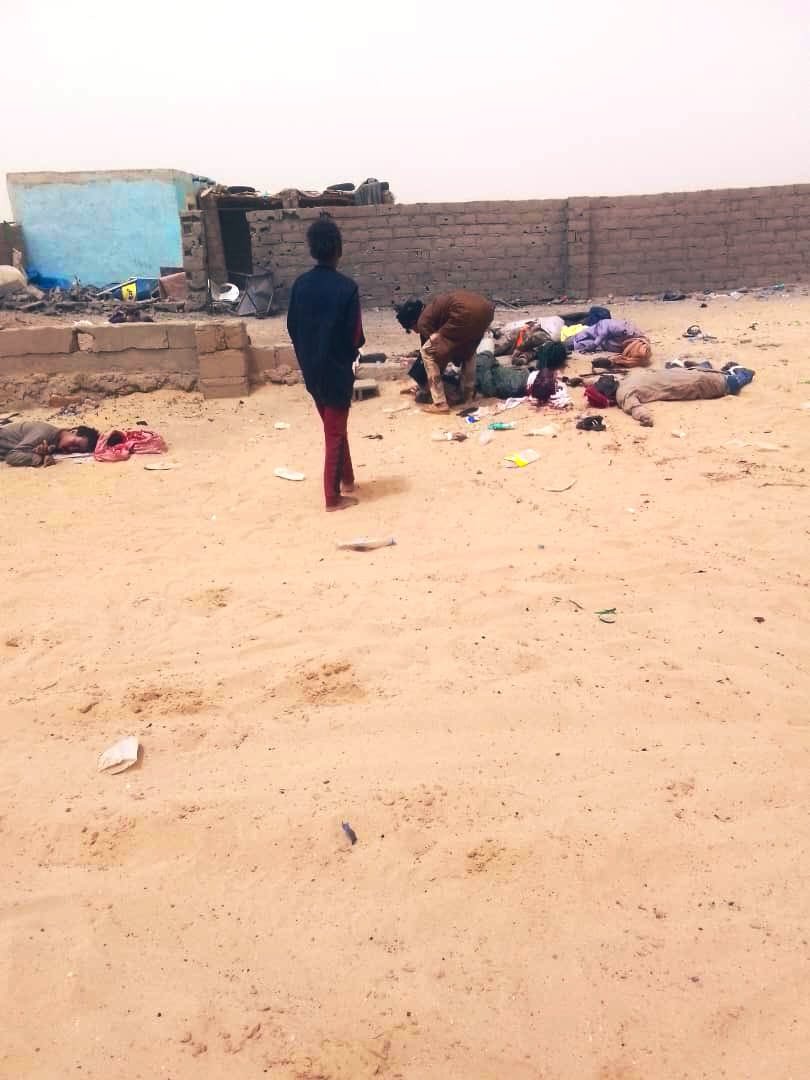
❌

Visualização de leitura

How Online Maps Lay Bare the US Military Bases Targeted by Iran

Sign up here to receive Bellingcat’s biggest investigations by email as soon as they are published. Become a member and support our work here.

In September, CBS News obtained new images of the aftermath of attacks on US bases in the Middle East from active service members. One told the news channel: “This is major damage to our bases that hasn’t been communicated to the American public. “We’re standing there with our eyes closed getting punched in the face,” they added.

While reports have detailed how Iran used Russian intelligence, including satellite imagery, to identify US troops, ships and aircraft, Bellingcat found that publicly available mapping platforms also reveal detailed and potentially sensitive information about US military bases in the Middle East. 

Google Maps and other online mapping services contain dozens of labels identifying facilities including headquarters, accommodation, gyms and fuel points. Publicly available photographs and videos, including material published by the US military, provide further details about how these facilities are used.

Experts told Bellingcat that such information could have helped inform Iranian targeting decisions by revealing where personnel gather and how bases operate. However, they cautioned that Iran would also have had access to other sources of intelligence. Reporting from Reuters earlier this year also highlighted how US officials believed commercially available location data was being used to target US troops in war zones.

The bases examined by Bellingcat are not secret and have operated for years in a region where US forces maintained a strong sense of security. Joseph Jarnecki, a research fellow at the Royal United Services Institute, said the US had been able to maintain aerial superiority and was understood to have significant air defence capabilities, but that Iran’s missile and drone campaign has undermined both assumptions. 

Iranian strikes have damaged at least 20 US military sites across Qatar, Bahrain, the United Arab Emirates (UAE), Jordan, Kuwait, Iraq and Saudi Arabia since the conflict began in February this year.

Governments can request that Google blur or remove sensitive information from its services and Google publishes data on government requests for content removal.

Bellingcat contacted the US Department of Defense who asked us to reach out to CENTCOM about the details in this story. We also contacted Google. However, we did not receive responses to questions from these respondents before publication.

We examined four of the largest and most heavily affected US military installations by Iran’s missile and drone campaign: Camp Buehring and Camp Arifjan in Kuwait, Muwaffaq Salti Air Base in Jordan and Al Udeid Air Base in Qatar. At each one, we found publicly available Google Maps information providing details about facilities inside the bases and how they are used.
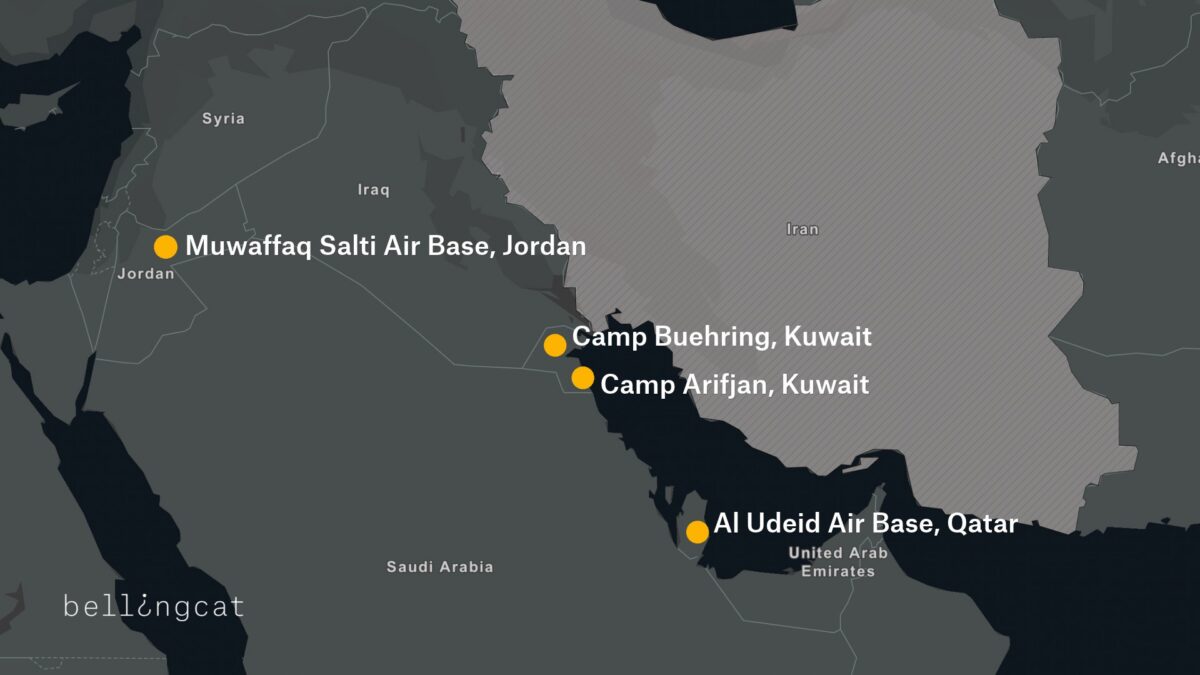
A map detailing four US bases that were attacked by Iran during 2026 conflict.

Camp Buehring

At Camp Buehring in Kuwait, Google Maps identifies what is labelled as the main headquarters building, as well as a gym and a self-help facility, all of which were among locations destroyed by recent Iranian strikes. In addition to Google Maps place markers there are dozens of reviews and user-uploaded photographs.
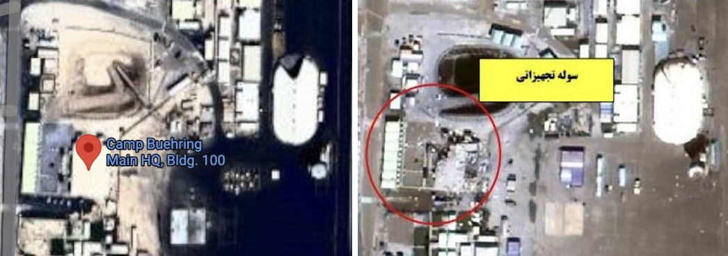
Left: Screengrab showing “Camp Beuhring Main HQ, Bldg. 100” Google Maps label. Right: Same building seen destroyed on satellite image published by Iran’s Tasnim news agency.

Bellingcat verified that this was a headquarters building by matching the flagpoles and layout in a photo published by the US military’s Defense Visual Information Distribution Service (DVIDS) showing soldiers posing in front of the  building to the Google Maps satellite image.
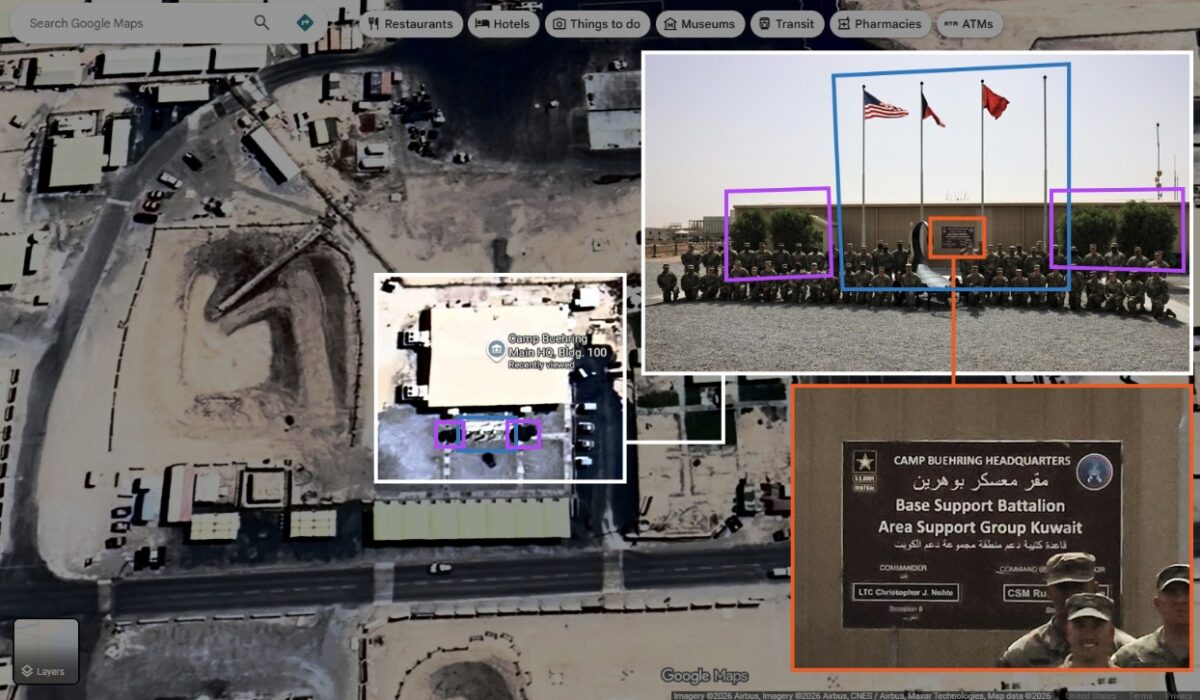
Geolocation diagram using dvids photo to verify Google Maps Buehring main headquarters location, confirming the accuracy of the Google Maps place marker.

We also identified details about one of the camp’s gyms, including the building’s layout and roof structure, as well as Google reviews that indicate when it is busiest.
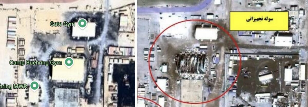
Left: Google Maps label showing “Camp Beuhring Gym” Right: Destroyed gym building on satellite image published by Iran’s Tasnim news agency on 6 April 2026.

Among the images published by CBS News in September was that of a heavily damaged tent-like structure with smoke rising from it. Bellingcat matched the location of this image to the above satellite imagery, verifying that it shows the gym building pinned on Google Maps.

⚡🚨 Exclusive images released showing damage to E-3 Sentry AWACS aircraft at Prince Sultan Air Base in Saudi Arabia, plus damage to US military camps Arifjan and Buehring in Kuwait from Iranian strikes. Images sent to CBS by active US military personnel. (IRIB News) https://t.co/1urA44f4xz


— Middle East Observer (@ME_Observer_) September 15, 2026
Left: Google Maps shows images of the gym’s interior and exterior. Right: Google Maps reviews indicate when the gym is busy (names blurred by Bellingcat).

A building labeled on Google as “DPW Self-Help Center” was also destroyed at Camp Buehring. Its Google Maps listing includes opening hours, and a photo posted by a Master Sergeant in 2017 labeled “My office in Kuwait” shows the interior of an office. Some of the notices on the walls inside the office are legible, including what appears to be a floor plan.
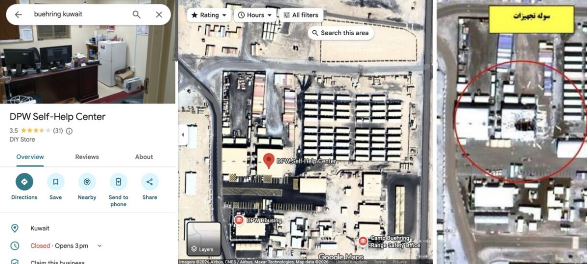
Left: Google maps “DPW Self-Help Center” listing. Right: Same building seen destroyed on a satellite image published by Iran’s Tasnim news agency on April 6, 2026.

A Google Maps placemark labelled “Transient Tent” identifies a large accommodation area, while another review includes a ground-level photograph of one of the tents. The dining facility can also be seen from the inside, including information regarding meal times.
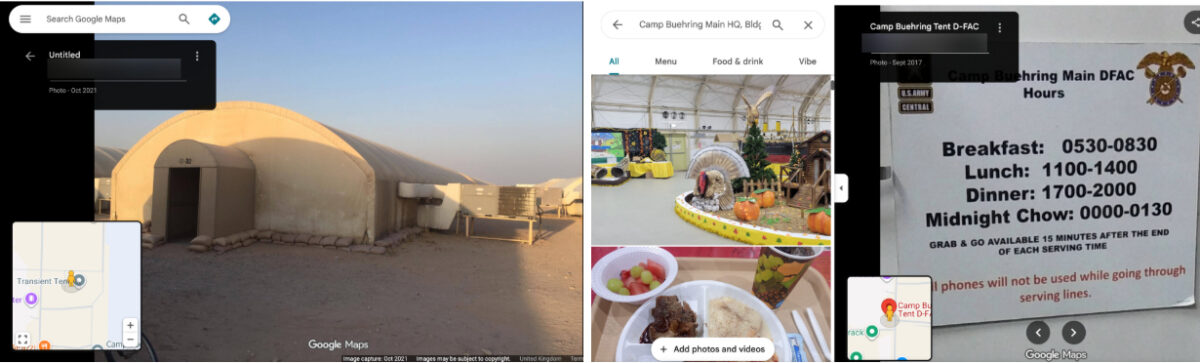
Left: Google image that appears to show an accommodation area. Right: Photos of the dining facility, including information on meal times (names blurred by Bellingcat).

William Goodhind of Contested Ground, a visual forensics consultancy that uses OSINT and satellite imagery to analyse military sites, said the information available on Google Maps could reveal “the camp’s layout, the division between secure and non-secure areas, confirms likely accommodation areas, and shows day/time periods of low and high activity.”

Camp Arifjan

A satellite image of Kuwait’s Camp Arifjan, captured by Planet on March 4, 2026 and published by the The Washington Post, shows damage to numerous structures at the base. Bellingcat compared the image with publicly available mapping data to identify two damaged facilities.

A Google Maps listing for a lodging facility labelled “TPE FOR ARIFJAN” includes a soldier’s review discussing room reservations, accommodation shortages and cleaning schedules, indicating that the building was used for military housing. Although Google’s satellite imagery of the base is blurred, the facility is visible in unblurred Bing Maps imagery using coordinates obtained from its Google Maps listing. The satellite image published by The Washington Post shows heavy damage to the facility.
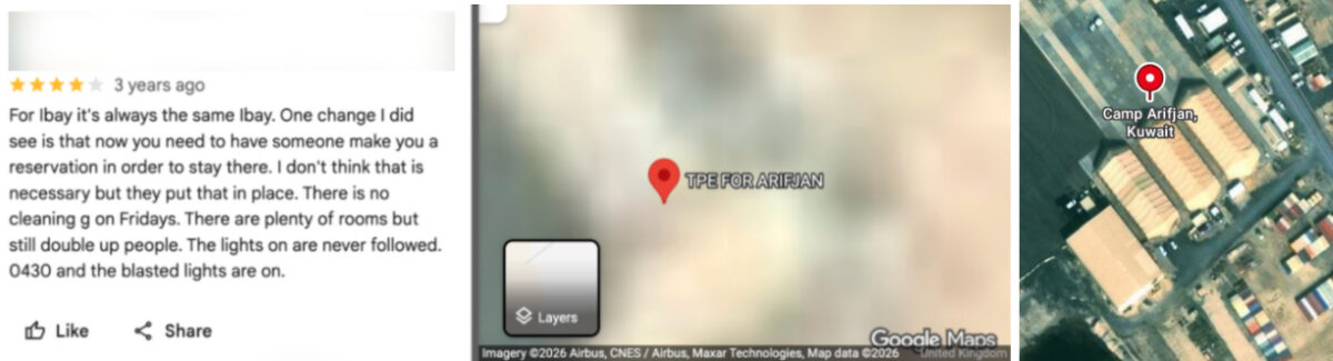
Left and centre: Blurred Google Maps satellite image with Google review (name blurred by Bellingcat). Right: Unblurred Bing maps satellite image showing the same location.

A “24hr Fuel Point” tagged on Google Maps is also blurred, but when the coordinates are copied and pasted into Bing Maps a clear satellite image of the fuel station appears. This facility is also seen destroyed on the satellite imagery published by The Washington Post.
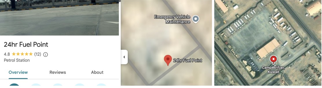
Left and centre: Blurred Google Maps satellite image with Google review. Right: Unblurred Bing Maps satellite image.

Bellingcat contacted Microsoft to ask why the facility was not blurred out in the Bing Maps service. A spokesperson said: “When an entity requests removal from visibility on Bing Maps, we work through our process and act accordingly.”

Muwaffaq Salti Air Base

Three US service members were killed in Iranian ballistic missile strikes on Muwaffaq Salti Air Base in Jordan on July 17, 2026. The strikes appear to have caused extensive damage to a barracks in the north of the base, with satellite imagery released by Iran showing at least 20 structures destroyed.

Less than 40 metres from the nearest destroyed structure, and within the same living quarters area, Google Maps reveals the location of an “Airman’s Attic”. These are volunteer-run thrift shops for US Air Force personnel. 

A five-star review posted last year by a soldier includes a ground-level image of the facility, showing uniform drop-off points and fortifications along the perimeter. The listing provides information about the area’s use, while photographs of the shop’s exterior make it possible to match the satellite imagery to the location on the ground.

A Sky News investigation also found that 80 percent of the runs shared publicly on the sporting app Strava at Muwaffaq Salti Air Base during the April ceasefire started or finished in this northern barracks.
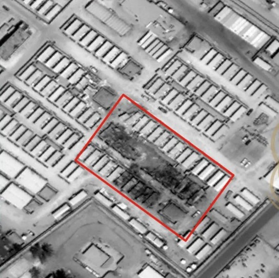
Satellite image showing damage, highlighted in red, published by Iran’s Fars News Agency.

Less than 100 meters from the destroyed area, “LSA DFAC” is pinned on Google maps. “DFAC” is the standard US military acronym for “dining facility”, according to Stars and Stripes. Several Google reviews also discuss the steak being served in this location.
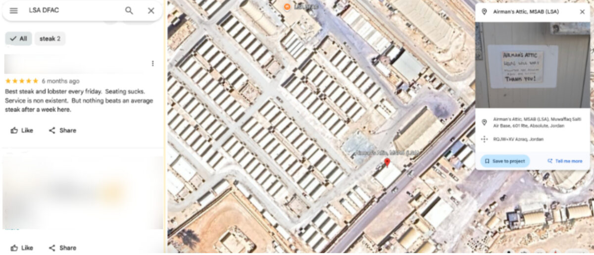
Left: Google reviews for the dining facility (names blurred by Bellingcat). Right: Google Earth satellite image with the Airman’s Attic and dining facility visible in the area targeted by Iran.

Al Udeid Air Base

Similar mapping information is available for Al Udeid Air Base in Qatar, the largest US military installation in the Middle East. 

The base appears unblurred on Google Maps and entries on the platform identify the functions of numerous buildings. These include lodging facilities, which videos and reviews indicate are used by US Air Force crews and show the interior layout of the facility.
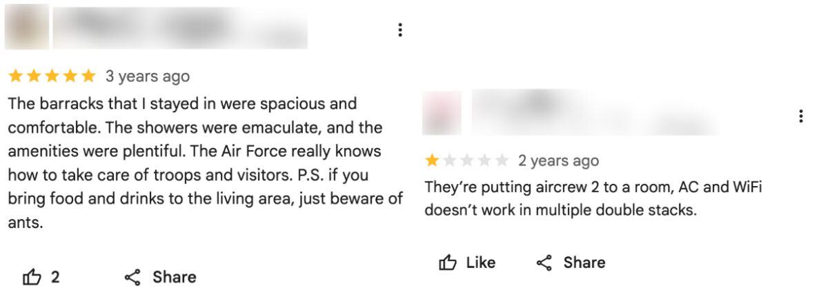
Google reviews for “Al Udeid Lodging” indicate the presence of US Air Force crews (names blurred by Bellingcat).

Meanwhile, Russia’s Yandex Maps details the site of two cinemas, a bar and a school on the base. This appears to match information provided on Google Maps.

While Al Udeid Air Base was damaged during Iranian attacks earlier this year, the areas that were struck do not appear to be among those listed on Google. 

Business Insider reported that a geodesic dome that housed secure communications equipment was hit in the strikes. ABC News detailed how another building had been damaged near the centre of the base. Google Maps shows a large warehouse-like structure at the location where ABC News reported this strike.

A New Reality in the Middle East

Former US Air Force targeting specialist Wes J. Bryant said the problem facing US bases in the Middle East reflected a broader assumption within the military that bases in allied countries were safe from serious attack. He said the belief that these were rear-area bases where “nothing’s going to happen out here” was a fundamental miscalculation, and that the Google Maps issue was an example of the military failing to account for that vulnerability.

Matthew Savill, Director of Military Sciences at the Royal United Services Institute, said Western militaries do not have consistent policies governing what information can be publicly posted about sensitive sites. He said the issue needs to be considered before a conflict begins, rather than when attacks are already underway. “The start point should be, can we enforce operational security discipline?” Savill pointed to restrictions already in place at some UK military facilities, including Faslane, a naval base that houses the UK’s nuclear submarines, where he said personnel are not permitted to use mobile phones on site.

Savill told Bellingcat that the different pieces of data available on Google Maps, even if outdated, provided a “pattern of life” about US bases in the Middle East. But he added that the use of Google to help with the military targeting of Western bases is not new, saying he encountered the issue while deployed to Iraq more than 20 years ago.

“When I was in Iraq, we knew for a fact that insurgents and militants had been using commercial imagery, including Google Earth, to try and map our bases,” he said. “We have known for more than 20 years that there is a vulnerability that if you don’t stop the collection and layering of data early on, that your bases can be heavily mapped.” 

The use of open-source information to support military targeting has been documented in Ukraine. In 2022, Foreign Policy detailed how Ukrainian private intelligence company Molfar used photographs of Russian soldiers published by Russian media alongside Google Earth satellite imagery to identify their location. Molfar passed its findings to Ukrainian intelligence, and the site was subsequently struck by the Ukrainian military.

The security risks of publicly mapping military installations were recognised by the US military in 2008, when the Pentagon banned Google’s Street View from documenting the interiors of its bases. Since the Iran war started, US military commanders have also warned service members about posting photographs and videos from bases after Iranian attacks, cautioning that such footage could help Iran assess the effects of its strikes.

Iranian attacks have forced US personnel to evacuate many additional locations that were deemed too vulnerable to further strikes. 

In total, 23 US service members have been killed and 865 wounded in the US-Iran war, according to the Pentagon.


Bellingcat’s Jake Godin, Charlotte Maher and Merel Zoet contributed to this report.

Bellingcat is a non-profit and the ability to carry out our work is dependent on the kind support of individual donors. If you would like to support our work, you can do so here. You can also subscribe to our Newsletter and follow us on Bluesky here, Instagram here, Reddit here and YouTube here.

The post How Online Maps Lay Bare the US Military Bases Targeted by Iran appeared first on bellingcat.

“A Recurring Pattern”: Civilians Paying the Price in Mali’s Drone Campaign

Sign up here to receive Bellingcat’s biggest investigations by email as soon as they are published.

WARNING: This report contains links to graphic images and footage.

A joint Bellingcat and Jeune Afrique investigation into drone strikes carried out by the Malian military adds new details about the attacks which frequently are carried out in civilian areas and have reportedly resulted in the deaths of civilians.

The incidents, concentrated in northern Mali, often involved strikes on vehicles or commercial activity. Video footage of the strikes is often broadcast on national television, portrayed as precise attacks against terrorists and their logistics. 

Mali’s military government acquired its first Turkish-made Bayraktar TB2 drones in late 2022, and regularly releases footage of drone strikes to be broadcast on national television, describing them as “precise” and describing the targets as “terrorists and their logistics”. This month marks three years since Mali joined with Burkina Faso and Niger to form the Alliance of Sahel States (AES). Its military government has made restoring national sovereignty a central part of its political message. 

Support Bellingcat

Your donations directly contribute to our ability to publish groundbreaking investigations and uncover wrongdoing around the world.

Bellingcat geolocated more than a dozen drone strikes including instances in which civilian deaths and injuries were reported. However, this represents just a fraction of the strikes that have taken place in northern Mali, with many more conducted for which footage was not available or further details were harder to verify as the locations are so remote.  

Yvan Guichaoua Senior Researcher at the Bonn International Centre for Conflict Studies told us the Malian military’s drone strikes appeared to fit a pattern of “guilt by location” in which people may be treated as targets based on where they are rather than who they are. 

He added that the broadcast of drone strikes on national television, often accompanied by dramatic commentary created a familiar narrative for veiwers that was akin to daily episodes “of a national saga”. Yet the impact of the drone war on civilians and non-combatants is seldom covered in such reports. 

Mali’s civil war involves separatist and Islamist groups and has been ongoing since 2012, predating the formation of the AES. But the conflict has spiked in 2026 as Tuareg separatists from the Azawad Liberation Front (FLA) and militants from the al-Qaeda affiliated Jama’at Nusrat al-Islam wal-Muslimin (JNIM) seized control of parts of the country’s north in coordinated attacks against the Malian military and Russia’s Africa Corps forces. The Malian military (known hereafter by their official name Forces Armées Maliennes or FAMa) has relied heavily upon drone strikes in response. 

We contacted FAMa and put our findings to them but did not received a substantive response at time of publication.

Destruction in Zouera

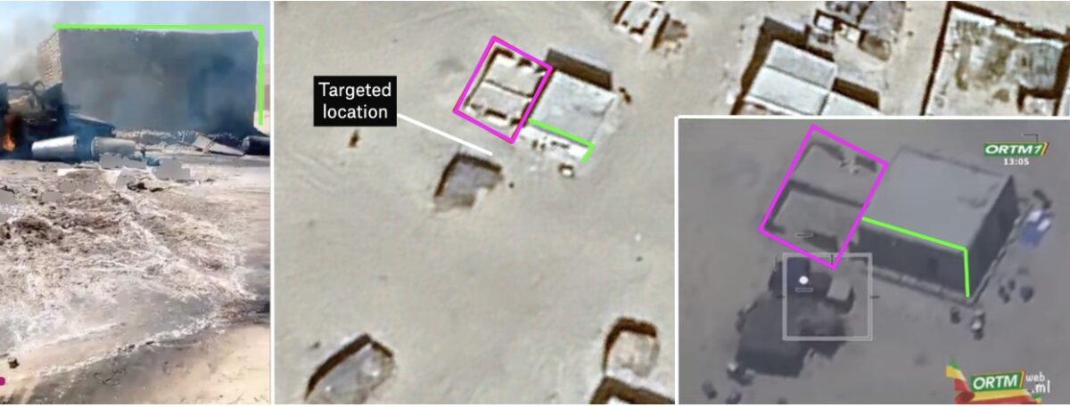
In one notable case – on July 8, 2025 FAMa presented a drone strike in the town of Zouera, in the Timbuktu region, as a successful operation against a supply vehicle for terrorists in footage broadcast on ORTM1 [4:50-5:31]. Drone footage shows a person walking near the vehicle before it is struck. The explosion immediately ignites a nearby structure, while several people can be seen running away.

One video of this incident, apparently showing the aftermath of the attack, shows the remains of a person inside the burnt-down structure, which was located directly beside the vehicle that was hit in the strike. We also checked satellite imagery and found a noticeable burn scar at the location in imagery taken on Jul 9, 2025, that wasn’t visible the previous day.

Bellingcat geolocated the strike site to the coordinates 16.84589, -3.85213, inside Zouera. Several videos filmed in the immediate aftermath show the destroyed vehicle, a large plume of black smoke, and the nearby structure engulfed in flames.

Geolocation diagram showing Google Earth satellite image (middle) with a screengrab of aftermath footage blurred by Bellingcat (left) and drone-footage shown on ORTM 1 (right). Sources: X/@AmakanessAg and Youtube.

Information gathered by Médecins Sans Frontières (MSF) and posted on X on July 11, 2025, stated four people were killed in the strike, including three young girls. MSF added that five others were treated for injuries at a local health centre, one of whom was in a serious condition. 

#Mali🇲🇱 : Après une frappe aérienne ayant touchée le marché de #Zouéra, cercle de Goundam, région de #Tombouctou, les équipes MSF ont pris en charge ce mardi 8 juillet 5 blessés, dont un cas grave, au centre de santé local. 4 personnes ont perdu la vie, dont 3 jeunes filles. pic.twitter.com/cTdLiY9bG8
— MSF Western & Central Africa (@MSF_WestAfrica) July 11, 2025

Amasrakad Strike

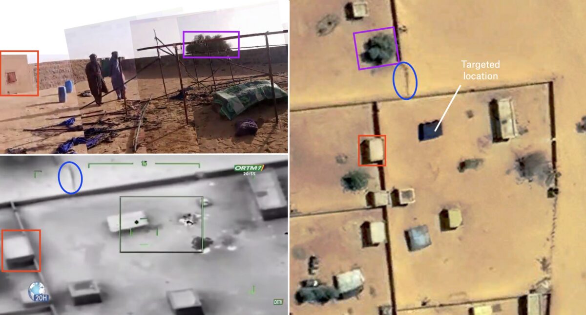
Zouera was not an isolated incident. Footage from March 2024 that was released by the Malian military and again aired on ORTM1 showed two drone strikes in the town of Amasrakad that resulted in the deaths of civilians, according to witness testimony and previous reporting by Amnesty International.

The footage shows an initial strike hitting a parked pick-up truck before cutting to a second strike on a nearby compound, where several people can be seen running moments before impact. The first strike was geolocated to the coordinates 17.08402, 0.76204, by France 24.

Bellingcat geolocated the second strike to a structure within a nearby compound at coordinates 17.081613, 0.768012, where the drone footage shows several people scrambling before impact. Separate graphic footage published by the Spokesperson for the Awazad Liberation Front on X the following day shows several dead people including what appeared to be women lying in and around the compound. France 24’s previous reporting on the strike included images of covered bodies inside a destroyed tent, as well as an image of a child that was reportedly injured during the strike. 

Our partner Jeune Afrique obtained testimony from the man who filmed the footage. He said the second strike killed 13 members of two families, including several children, who had gathered in a tent for shelter after the first strike. He added that he helped take eight injured people to health centres. The man told Jeune Afrique he has now joined the separatist FLA group following the attacks.  

This testimony would appear to support a 2024 Amnesty International report that stated at least 13 civilians, including seven children, were killed and more than a dozen people injured. Amnesty reported speaking to seven survivors and eyewitnesses who said the first strike hit a Toyota Hilux used by the local health centre. Believing the vehicle had been the target, residents fled to a nearby compound to seek shelter. The second strike then hit the compound directly, the Amnesty report stated.

Geolocation diagram showing Google earth satellite image (right), screengrab of aftermath footage (top-left) and screengrab of drone footage (bottom-left). Sources: X/@MohmedRAMADANE and Youtube.

The FAMa claimed in an official statement just after that attack that: “These operations neutralised several terrorists and destroyed a significant quantity of military equipment and vehicles.” While the pro-Azawad separatist group, the CSP gave a different account, condemning the strikes and claiming that they had killed 13 of which a majority were women and children. 

We contacted FAMa to ask whether it maintains that those killed were members of an armed group, whether steps were taken to establish if civilians were present before the strike was carried out and whether an investigation was done into the reports of civilian deaths. We did not receive a reply at time of publication.

Two Strikes in Tinzaouaten

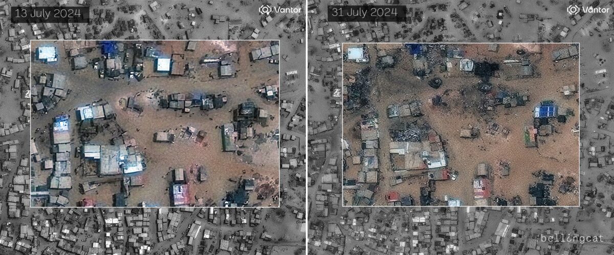
Some of the cases we geolocated had been documented previously. However, we were able to add new details about several strikes. The town of Tinzaouaten near Mali’s northeastern border with Algeria endured two major drone strikes in 2024, reportedly in retaliation for a major assault carried out by separatist and Islamist forces against Malian troops and Russian mercenaries. On July 30, 2024, the Malian military stated it had launched an air campaign around Tinzaouaten in coordination with the military government of Burkina Faso and had targeted “high-value targets”, including caches, logistics hubs and vehicles.

Bellingcat geolocated this footage posted on the day of the strike to 19.92476, 2.98003. The footage shows several damaged structures and what appears to be one casualty.

Satellite images of the geolocated area in Tinzaouaten from 13 July 2024 (left) and 31 July 2024 (right), the day after the strike. Heavy destruction visible in the area highlighted by Bellingcat. Satellite imagery credit: ©2026 Vantor.

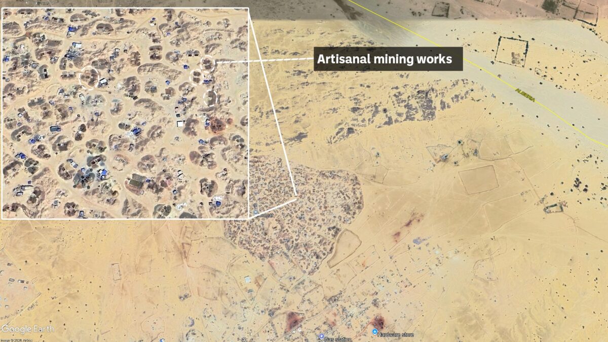
Pits and infrastructure which appear to be consistent with a mine are visible in satellite imagery of the area.

Diagram using Google Earth satellite imagery showing artisanal gold mining area in Tinzaouaten (19.93382, 2.98605), close to the Algerian border. 

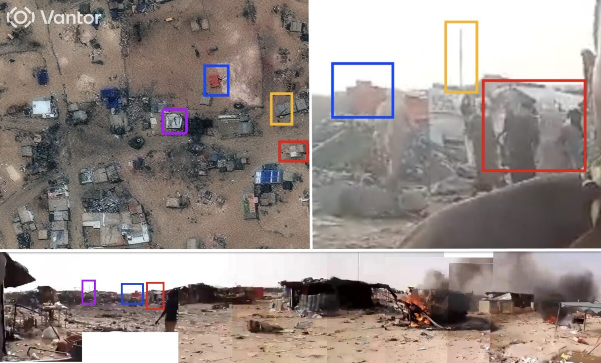
Bellingcat geolocated an additional video posted by a pro-Azawad media outlet showing destruction posted on X to the coordinates 19.92502, 2.98013. In another video geolocated to this site, a man claims he is at the “Inkharaban mine, near the Azawad-Algeria border.”

Geolocation diagram using aftermath footage showing destruction in Tinzaouaten, matched to 31 July 2024 satellite image provided by ©2026 Vantor. Sources – Top-left: satellite image annotated by Bellingcat, Top-right: X/@tankaranet, bottom: X/@AhmadouAtafa.

The Second Strike

A month later, on August 25, 2024, FAMa stated it had identified pickup trucks carrying military equipment in Tinzaouaten. It said that, “After careful surveillance, a series of strikes destroyed these terrorist targets and neutralized around twenty armed individuals.” On news channel ORTM1 the newsreader described the operation as “precision strikes targeting terrorist objectives”. 

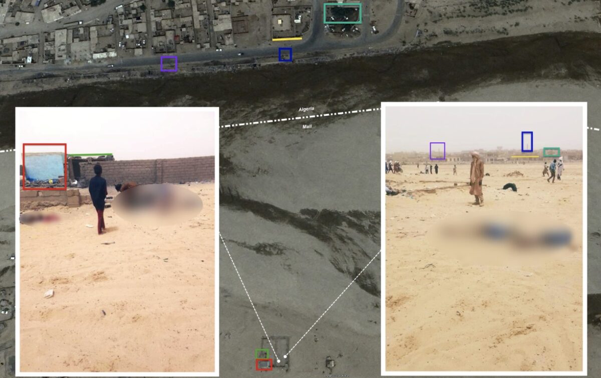
Bellingcat geolocated footage shared online by the pro-separatist Press and Media Agency of Azawad showing the destruction at the coordinates 19.95107, 2.97284, in Tinzaouaten.

Bellingcat also geolocated two images showing casualties at this location. One image shows a group of around eight bodies, while another graphic image shows the bodies of two young boys around 20-meters away (19.9512, 2.97307). We could not confirm whether or not those pictured were civilians though a resident told Reuters that civilians were killed in drone strikes on the town.

Geolocation diagram using Google earth satellite image, with screengrabs showing casualties. Victims blurred by Bellingcat. Sources: X/@InfosMinutesFR.

Bellingcat contacted FAMa to ask about the two strikes in Tinzaouten in the summer of 2024. We asked the military what steps were taken to establish whether civilians were present when the strikes were carried out and whether any investigation has been carried out into the two strikes, but we had not received a response at time of publication.

In addition to the above incidents Bellingcat geolocated additional drone strikes based on footage broadcast on ORTM and added them to the below map. We were not able to confirm who was killed in the additional strikes but evidence we analysed show strikes often taking place within populated villages or against vehicles and fuel supplies.

Shahed-Type Drones Filmed During Mali Village Attacks

Bellingcat has geolocated footage showing Shahed-136 type kamikaze drones in operation in Mali.

Defence Blog and France 24 previously published reports that these drones were being deployed on the battlefield in northern Mali. But Bellingcat and Jeune Afrique subsequently verified two recent strikes using geolocation, satellite imagery and expert analysis to provide some of the clearest open-source evidence to date documenting their deployment.

The two strikes took place in the villages of Inafarak on July 12 and Talahandak on July 17. While the available evidence does not allow the exact variant to be identified, experts told Bellingcat it is quite likely the drones were manufactured in Russia given the deployment of the Kremlin-controlled Africa Corps group and the broader pattern of Russian military support to Mali.

Leo Jarry, a drone expert with Tungsten Strategies, told Bellingcat: “If the drones are Russian manufactured, they represent a visible demonstration of Russian support for Mali.”

Reports that Russian drones had been used in Mali first emerged in May, when Defence Blog published photographs of drone wreckage from strikes near the town of Savare.

Earlier this month, France 24 also identified debris from several Russian drone systems in Mali, pointing to an expanding Russian drone presence in the country. Until now, however, there has been no verified footage showing how Shahed-136 type drones in flight and hitting targets. 

Mali has been mired in conflict since a rebellion erupted in the country’s north in 2012. In recent years, Russian forces, first through the Wagner Group and now through its successor, Africa Corps, have supported the Malian Armed Forces (FAMa) in operations against Tuareg rebel groups and jihadist organisations

Inafarak –  July 12, 2026

On  July 12, footage showing the aftermath of a drone strike in the village of Inafarak was published on X.


Bellingcat geolocated the footage to the town, which is close to the border with Algeria (21.32330, 0.72980) using satellite imagery. We confirmed the location by comparing a post-strike satellite image captured on July 15 with imagery from 2024. The comparison shows several buildings that were standing in 2024 had been destroyed by July, 15, 2026. This damage was consistent with that visible in the geolocated footage. The strike appears to have hit a commercial facility, with a damaged truck and numerous damaged fuel drums visible.

A geolocation diagram showing satellite imagery (top) and a screen grab from footage (bottom) that allowed us to match the site of the strike to Inafark. Satellite Image credit: Planet Labs PBC. Social footage from @EypeMohamedn.

One of the videos shows the remains of an engine which appears consistent with an MD-550, a distinctive four-cylinder two-stroke engine which is found on the Shahed-136 family of drones. We showed the image of the engine to two weapons researchers – Trevor Ball, an independent weapons expert and former Bellingcat investigator, and Leo Jarry, a drone expert with Tungsten Strategies – who said the engine is consistent with the Shahed-136 family of drones.

The component also closely matches reference imagery of MD-550 engines published by the Open Source Munitions Portal (OSMP), an expert-reviewed database of documented weapons remnants, and on the war & sanctions component database.

Left: Screengrab showing the MADO MD-550 engine found in Inafarak. Source: X/@EypeMohamedn. Right: Verified comparison image showing a MADO MD-550 engine. Source: OSMP.

Support Bellingcat

Your donations directly contribute to our ability to publish groundbreaking investigations and uncover wrongdoing around the world.

The footage we found on X was  also republished by the Wagner- and Africa Corps-affiliated Telegram channel “White Uncles in Africa”, which regularly shares racist memes and graphic posts  and which Bellingcat has previously reported on.

The channel captioned the videos: “Now the Azawadi ‘khokhols’ will be seeing Gerans all the time.” The use of “Geran” refers to a Russian-manufactured version of the Shahed-136. The post also uses the derogatory Russian slur “khokhol” for Ukrainians and applies it to people from Azawad, the name used by Tuareg separatists for northern Mali.

Talahandak –  July 17, 2026

On  July 17, graphic footage showing the aftermath of another Shahed-136 type drone strike was posted on X, showing one casualty as well as a burning truck. An additional video of the burning vehicle shows what appear to be bottles of cooking oil spilling from the truck indicating it may have been a commercial truck.

Bellingcat geolocated these videos to the village of Talahandak (20.26369, 1.80095), which is also close to the border with Algeria but around 100 miles southeast of Inafarak, by matching the surrounding buildings to satellite imagery.

A geolocation diagram showing satellite imagery (top) and a screen grab from footage (bottom) that allowed us to match the site of the strike to Talahandak. Satellite Image credit: Planet Labs PBC. Social footage from X/@mahmoud_sahara.

Shortly afterwards, a Wagner-affiliated X account claimed that the drone responsible for the strike had been shot down by rebels before hitting the truck. The post showed one video where a Shahed-type drone could be seen in flight.

We were able to geolocate where the footage that captured the drone’s final moments before impact was filmed to another area of Talahandak, nearly a kilometer away (20.266907, 1.792656) from the video that showed the impact site.

Geolocation diagram showing satellite imagery (right) and footage (right) showing Shahed-136 type drone in flight, using high-resolution Planet satellite image from July 23, 2026.

A distinctive smoke plume can be seen rising from the sight of impact in several other videos posted online shortly after the strike. 

Bellingcat geolocated each of these videos and matched the plume of smoke adding further confirmation that the footage showing the drone in flight is authentic. 

The video shows the drone descending directly towards the location where the person and truck were hit, and there appears to be no interception before impact.

Screengrabs showing matching smoke plume across verified imagery. Left – Source: X/@EypeMohamedn. Middle – Source: Facebook/Ali Ould Right – Source: Facebook/ⵢⵙⴰⵍⴰⵏ24اخبارNewS

A New Weapon Raises New Risks

The Shahed-136 is a series of long-range one-way attack drones originally developed in Iran and now also manufactured in Russia. Unlike the drones typically used by Mali’s Armed Forces- the  Bayraktar TB2 , which launch relatively small precision-guided munitions before returning to base, one-way attack drones are designed to explode on impact, allowing them to attack over longer distances given they do not require recovery.

Leo Jarry, a drone expert with Tungsten Strategies, told Bellingcat that the drone provides Africa Corps and FAMa with an “expendable, cost-effective” long-range strike capability, allowing them to engage targets in Mali’s far north beyond the effective reach of the Bayraktar TB2. “The fact that these systems are relatively cheap and expendable changes the risk calculation for operators,” Jarry said. “They can be used more freely, potentially forcing insurgents in northern Mali to adapt their behaviour to a new aerial threat.”

However, Jarry said the system is inherently less precise than the Bayraktar TB2 because it cannot verify its targets during flight. Instead, it relies on separate surveillance assets to identify and track targets before launch. “In Mali, where armed groups are highly mobile and frequently operate among civilian populations, any gap between target identification and impact creates a risk of striking the wrong target.” Combined with the drone’s larger warhead, this increases the potential for civilian harm when employed in or near populated areas.

From Ukraine to Sahel

In Ukraine, Russian forces have used Shahed-136 type drones extensively in long-range strike campaigns that have repeatedly targeted civilian infrastructure, causing civilian casualties. Their appearance in Mali raises the possibility that the operational practices associated with these weapons are also being exported to this conflict. 

The deployment  also follows Bellingcat’s and Jeune Afrique’s recent investigation documenting the use of banned Russian cluster munitions in Mali.

Malian forces and Africa Corps currently face mounting pressure in northern Mali following a series of rebel offensives. Fighting has intensified in recent months, with rebels capturing several military bases and reportedly inflicting heavy losses on both FAMa and Africa Corps. 

Jarry told Bellingcat that the relatively low cost and expendable nature of these new drones make them well suited to retaliatory strikes following attacks by rebels.


Bellingcat’s Carlos Gonzales contributed to this report as well as the following members of Bellingcat’s volunteer community: Nicole Kiess, Afton Briones, Riccardo Giannardi and Ziyu Wan.

Bellingcat is a non-profit and the ability to carry out our work is dependent on the kind support of individual donors. If you would like to support our work, you can do so here. You can also subscribe to our Patreon channel here. Subscribe to our Newsletter and follow us on Bluesky here, Instagram here, Reddit here and YouTube here.

The post Shahed-Type Drones Filmed During Mali Village Attacks appeared first on bellingcat.

Banned Russian Submunitions Found After Mali’s Military Announces Airstrikes

This investigation is a collaboration between Bellingcat and Jeune Afrique. You can read Jeune Afrique’s article in French here.

Unexploded Russian-made cluster munition bomblets, as well as damage consistent with bomblet impacts, have been found in a village in northern Mali – despite the West African country being a state party to the Convention on Cluster Munitions (CCM) which prohibits their use. 

The deployment of cluster munitions in northern Mali was first reported by Radio France International last week, citing local sources yet without showing images of the munitions or strikes in the reporting. However, social media footage posted on May 17, and since analysed by Bellingcat and our publishing partner, Jeune Afrique, shows unexploded Russian manufactured ShOAB-0.5 submunitions (bomblets).

Bellingcat geolocated a video showing the unexploded ShOAB-0.5 bomblets in the village of Tadjmart (18.977305, 0.86072), located approximately 55-kilometers (34-miles) south of the larger town of Aguelhok in northern Mali. This matches the location of airstrikes announced by the Malian Armed Forces (FAMa) on May 17. FAMa claimed it had identified armed groups in the area.

A map detailing where the Tadjmart strike, signified by the red flame, was recorded. Courtesy MapCreator.

Russia’s paramilitary Africa Corps group, which is controlled by the Russian government and which replaced the Wagner mercenary group in the country, has been supporting Malian military operations.

Mali’s civil war has been ongoing since 2012. But the conflict has spiked in recent weeks as Tuareg separatists from the Azawad Liberation Front (FLA) and militants from the al-Qaeda affiliated Jama’at Nusrat al-Islam wal-Muslimin (JNIM) seized control of parts of the country in coordinated attacks against Malian and Africa Corps forces.

Les mercenaires continuent de larguer des bombes sur des maisons et certains diront pourquoi se révolter contre ces genres des pratiques inhumaines ne respectant aucun Droit. https://t.co/5jynKwUgeW pic.twitter.com/nB3ym4yooc

— Mohamed Lilly (@MedLilly1) May 17, 2026

The footage geolocated by Bellingcat shows the unexploded submunitions near buildings, alongside multiple small craters, consistent with submunition explosions.

Left: Unexploded ShOAB-0.5 submunition found approximately 55 km south of Aguelhok. Right: ShOAB-0.5 Submunition. Sources: X and Armament Research Services.

The buildings and landmarks visible in the footage allowed us to geolocate where it was taken.

Geolocation of the video showing unexploded ShOAB-0.5 submunitions and the craters to the village of Tadjmart (18.977305, 0.86072). Sources: Airbus Imagery via Google Earth and X.

Additional footage geolocated by Bellingcat to nearby coordinates 18.97954, 0.85989 shows destroyed and burning buildings several hundred meters away, although this damage is not consistent with cluster munition use. The damage appears more significant than that which would be caused by submunition impacts.

Geolocation of the additional footage showing destruction several hundred meters away from where the submunitions were geolocated. Sources: Airbus Imagery via Google Earth and X.

Cluster munitions are explosive weapons which open mid-air to release large numbers of submunitions. They are prohibited from being used by signatories of the Convention on Cluster Munitions (CCM) because they are indiscriminate, saturate a wide area and can leave behind highly volatile unexploded bomblets which can kill civilians long after deployment. 

Support Bellingcat

Your donations directly contribute to our ability to publish groundbreaking investigations and uncover wrongdoing around the world.

While Mali is a signatory to the CCM, Russia is not a state party to the agreement. 

Brian Finucane, a senior adviser with the US Program at the International Crisis Group, told Bellingcat that as a party to the CCM, Mali is “subject to its prohibitions and requirements. These include not only prohibitions on the use of cluster munitions, but also obligations to clear and destroy such munitions on its territory.”

ShOAB-0.5 submunitions are carried by the Russian RBK-500 cluster munition dispenser. A single RBK-500 dispenser can deploy about 565 ShOAB-0.5 submunitions. There is as yet no footage posted online showing a spent dispenser linked to this incident.Footage did circulate online on May 16 showing the remnants of an RBK-500. It was claimed to have been used in a separate cluster munition strike in the Timbuktu region of Mali. However, this footage was not geolocatable, given it only shows a close up of the dispenser at night, nor was it possible to tell when the footage was taken.

A second video appears to show the same dispenser, but shows the side with visible Russian markings denoting the model: “РБК-500; ШОАБ-0.5; ТГ-30”. This identifies the dispenser, RBK-500, the submunition inside, ShOAB-0.5, and the explosive filler, TG-30.

Left: Markings visible on RBK-500 ShOAB-0.5 dispenser reportedly found in Mali. Right: Reference image of RBK-500 ShOAB-0.5 cluster munitions loaded onto an aircraft. Sources: محمدن أيب أيب and Telegram.

RBK-500 dispensers are deployed by Russian-made aircraft including several MiG and Su models. According to the 2024 IISS Military Balance report, Mali does not have any known operational Russian fixed-wing attack aircraft. Two Russian Su-25 aircraft delivered to Mali – one in 2022 and another in 2023 – are reported to have crashed and been out of service since late 2023.

An Su-24M model has since appeared in satellite imagery captured at Modibo Keita International Airport in Bamako. The imagery was first published by France 24 in April 2025, although it was unclear if this aircraft was, or has been, operated by Africa Corps or Malian forces.

Bellingcat contacted the Malian military and Russian Ministry of Defence requesting comment, and asking which force was responsible for deploying cluster munitions. We did not receive a substantive response by publication time beyond the initial statement made by the FAMa which detailed it was responsible for the May 17 strike.

A video posted on May 17, by an account linked to Azawad rebels in Northern Mali, shows a person handling components of a ShOAB-0.5 submunition, seemingly unaware of the danger. However, as the video shows only a close up of the submunition, it has not been possible to geolocate the video or confirm when it was taken.

Les Azawadiens ne fabriquent pas les armes au contraire ils les démontent ! pic.twitter.com/0tqOb6ut9G

— Oumayya AG Ambeiry (@AgOumayya) May 17, 2026

The FLA condemned the use of cluster munitions in a statement published on May 18. 

Bellingcat has previously reported on the use of cluster munitions in Syria and Ukraine and the danger they pose to civilians.


Youri van der Weide contributed to this report.

Bellingcat is a non-profit and the ability to carry out our work is dependent on the kind support of individual donors. If you would like to support our work, you can do so here. You can also subscribe to our Newsletter and follow us on Bluesky here, Instagram here, Reddit here and YouTube here.

The post Banned Russian Submunitions Found After Mali’s Military Announces Airstrikes appeared first on bellingcat.

The War You’re Not Allowed to See: How the UAE Rewrites the Story of Iranian Strikes

Bellingcat has identified several high-profile incidents where authorities in the United Arab Emirates have downplayed damage, mischaracterised interceptions and in some instances not acknowledged successful Iranian drone strikes on the country.

A review of official statements shows that the public account does not always align with what can be observed through open sources. This comes as the UAE faces sustained aerial attacks on civilian and economic infrastructure, challenging its image as a secure global hub for business and tourism. Hours after the United States and Israel launched coordinated attacks on Iran on Feb. 28, the Islamic Republic responded by launching an attack against US-allies in the region including the UAE. 

In the wake of the attacks, the UAE’s attorney general warned that publication of images or videos of strikes was illegal. People were also encouraged to report anyone sharing photos or videos of the strikes to authorities. 

The country’s attorney general has ordered the arrest of 35 people and said they would face an expedited trial for “publishing video clips on social media platforms containing misleading, fabricated content and content that harmed defence measures and glorified acts of military aggression against UAE.” Separately police in Abu Dhabi reported they had arrested just over 100 people on suspicion of filming incidents related to Iran’s attacks on the UAE and sharing misleading information online.

Bellingcat contacted the Dubai Media Office, the Fujairah Media Office as well as the UAE’s Ministry of Defence to understand how statements are put out and how distinctions are made between successful drone strikes and damage caused by debris. We did not receive a response by the time of publication.

“Spreading Rumours is a Crime”

During the first days of the conflict several videos were posted on social media, primarily on X, TikTok and Telegram showing footage of Iranian attacks and interceptions across the UAE. 

Around the same time the Dubai Media Office, the X account of the Government of Dubai’s press office, warned followers that legal action would be taken against those sharing “unverified material”.

 The X account of the Dubai Media Office has more than 2.3 million followers making it one of the largest state-run accounts in the country. 

“The public and media are urged to rely solely on official sources for accurate information and refrain from sharing unverified material,” the account posted.

Dubai Police issued similar warnings on social media, stating that sharing content that contradicts official announcements could lead to imprisonment of at least two years and fines of no less than 200,000 dirhams (approximately $55,000).

An image shared by Dubai Police on March 3, 2026. Source: X/DubaiPoliceHQ

Despite authorities urging the public to rely on official sources only, Bellingcat found that some of the videos posted online as well as satellite imagery from the region contradicts a number of official accounts of high-profile attacks. For this piece we have only included links to videos that have already been widely published in mainstream news outlets, posted by professional journalists, or have been widely viewed on social media.

Successful Interceptions?

On March 3, a video filmed from a vessel appears to show a drone striking the port of Fujairah, one of the UAE’s most strategically important energy hubs. The port handles roughly 1.7 million barrels of oil per day and is among the world’s largest.

The drone appears to approach its target intact, with no visible sign of interception, Sam Lair, a researcher at James Martin Center for Nonproliferation Studies, told Bellingcat. 

Moments after it descends behind storage tanks, an explosion is heard and a large plume of smoke rises from the site.

On the same day, the Fujairah Media Office stated that a fire resulted from debris following a successful interception, adding that the fire had been brought under control. Satellite images captured on March 4 and 5 show thick black smoke rising from the site. NASA FIRMS data also detected fires on March 3, March 4 and March 5. By March 7, satellite imagery shows at least three storage tanks fully destroyed (25.184565, 56.345481).

Satellite imagery of Fujiarah oil port from March 7, 2026, provided by Planet Labs PBC.

Detained in Dubai, a group that provides legal advice to people detained in the UAE, said that a Vietnamese national who filmed the strike on Fujairah port had been detained by authorities after posting the footage online. 

Authorities made a similar report on March 1, stating that a fire at one of the berths of Jebel Ali Port was caused by debris from an aerial interception. Satellite imagery from the same day shows fires at two separate locations – approximately 3 km apart – within the port. One appears to be a central facility associated with fuel handling operations, connected via pipelines to surrounding storage tanks (25.00704, 55.07499). The other is a large structure (24.97953, 55.05204) in the military area of the port, which is one of the US Navy’s busiest ports in the Middle East. The New York Times previously identified an Iranian strike as the cause of the fire at the site. 

Satellite imagery of Jebel Ali Port from March 1, 2026, Planet Labs PBC, inset imagery Google Earth. 

Burj Al Arab: A “Limited” Fire

Damage at Dubai’s Burj Al Arab Hotel was attributed by the Dubai Media Office to “shrapnel” from an intercepted drone and described as a “limited” fire. However, footage shows the fire extended to approximately 30 metres in height, covering approximately eight floors of the building, suggesting a far more significant incident than officially described.  

Lair told Bellingcat that the damage appeared more consistent with a direct impact. He added that if the damage had resulted from an interception it would have occurred irresponsibly close to the building.

Fairmont The Palm: Omission of Cause

On Feb. 28, the Fairmont hotel in Dubai’s Palm Jumeirah area was struck by a drone, as shown in footage verified by Bellingcat.

However the Dubai Media office did not confirm a strike took place, instead they stated  only that an “incident occurred in a building in the Palm Jumeirah area,” and urged the public not to share footage.

One video of the fire was shared by a Dubai-based Bloomberg journalist. In the replies to the journalist’s post, multiple users tagged the Dubai Police, a pattern seen across posts documenting the strikes, in an apparent effort to flag violations of the cyber-crime laws to authorities.  

The aftermath of the strike was also captured by a content-creator who has since left the UAE. 

Radha Stirling, founder of Detained in Dubai, told Bellingcat at least five people have been confirmed by the British embassy to have been charged and detained under the UAE’s cybercrime law in connection with documenting this strike. According to Stirling, authorities have sought access to individuals’ phones following incidents to determine whether they filmed or shared footage.

“Even just taking a photo is illegal, it’s illegal to share content that the government deems negative, even in a private message,” Stirling said.

Dubai International Airport: An Unacknowledged Strike

On March 7, the Dubai Media Office announced the temporary suspension of operations at Dubai International Airport, stating only that a situation was being handled under safety protocols. 

Footage that emerged online around the same time, and was verified by Bellingcat, shows a drone strike next to an airport terminal building (25.24165, 55.37498).

Stirling told Bellingcat that she has been in contact with a cabin crew member who was detained after sending an image to colleagues of Dubai airport after an explosion. 

Warda Complex: A Direct Hit

On March 1, a drone struck a residential apartment on the 19th floor of the Warda complex in Dubai (25.004320, 55.293164). Two videos filmed from different angles show the drone hitting the building directly, with no visible sign of interception. In one clip, filmed inside the apartment, a British resident says: “We’ve just been hit by a drone… I didn’t even finish my cup of tea.”

Geolocation diagram with screengrab of drone before impact. Satellite imagery provided by Google Earth. 

The footage shows relatively limited damage and no explosion, indicating the drone did not detonate. However, the incident appears to show a direct hit by an Iranian drone.

In contrast, statements published the same day by the Dubai Media Office describe air defence activity and attribute sounds heard across the emirate to successful interception operations. Bellingcat was unable to find any acknowledgement of a direct hit in UAE media.

These cases point to a gap between official accounts and observable evidence, raising questions about how incidents are being presented to the public.

Influencers and Narrative Control

At the same time, pro-government messaging has proliferated online. A number of near-identical videos posted by influencers promoting the UAE’s safety and leadership appeared, often using the format: “You live in Dubai, aren’t you scared?” followed by images of UAE leaders and the response: “No, because I know who protects us.” 

Screengrab of TikTok post, Source: makshaeva_aa

Analysis by the BBC found that some of these videos were uploaded within seconds of each other, suggesting coordinated activity.

Stirling told Bellingcat that influencers in the UAE, who require licences to operate, are often paid to promote official narratives. “They are seen as an asset,” she said, describing them as “almost an extension of the government.”

As of April 1, UAE media reported that a total of 12 people had been killed and 190 injured by strikes since the beginning of the war.  

“People are dying. It’s not as safe as the government is reporting. It’s not as safe as influencers are reporting. It’s like a dream narrative that you wish was true.” Stirling said.

Bellingcat also identified a number of incidents in which authorities reported deaths or injuries caused by “debris” following “successful interceptions”. In these cases, however, we were unable to identify supporting photo, video, or other independently verifiable evidence to corroborate the official account.

Notably, fewer videos of such incidents appear to have emerged online in recent weeks, likely as public awareness of detentions under the cyber-criminality law has increased.

Jonathan Dagher, head of the Middle East desk at Reporters Without Borders told Bellingcat that the UAE government was using the Iran war to further restrict independent reporting in the country. 

“When the conflict began, the government stepped up this repression, explicitly prohibiting the public (including journalists) from publishing photos or information related to the strikes, and encouraging the public to report on such incidents.”  

He added that legitimate concerns about national security should not infringe on the public’s right to information. 

“Broad and loosely worded bans on covering events, in the name of security, violate this right and expose journalists to arrest and violence.”

Bellingcat contacted the Dubai Media Office, the Fujairah Media Office as well as the UAE’s Ministry of Defence to understand how statements are put out and how distinctions are made between successful drone strikes and damage caused by debris. We did not receive a response by the time of publication.

Lana Nusseibeh, a representative of the UAE’s Foreign Ministry previously told the BBC: 

“In order for everyone to feel safe it’s important at this time that the information is credible and the sources are reliable. That is the basis of the legislation that has come into play in this State, which is obviously a tense time.” 

She added that her advice for residents, citizens, tourists and journalists in the UAE was to: “Follow the guidelines. The guidelines are there for your safety and for your protection.” 


Merel Zoet contributed to this report.

Bellingcat is a non-profit and the ability to carry out our work is dependent on the kind support of individual donors. If you would like to support our work, you can do so here. You can also subscribe to our Patreon channel here. Subscribe to our Newsletter and follow us on Bluesky here, Instagram here, Reddit here and YouTube here.

The post The War You’re Not Allowed to See: How the UAE Rewrites the Story of Iranian Strikes appeared first on bellingcat.

Munition Remnants Pictured at Site of Deadly Chad Strike Match Weapon Previously Used by Sudan’s RSF

Munition remnants pictured at the site of a strike that killed at least 17 people in the town of Tiné, Chad, last week appear to match a weapon previously used by Sudan’s Rapid Support Forces (RSF) in the war with Sudanese government forces – despite RSF denials of involvement in the incident.

Photographs showed what appeared to be a match for the rear control section of a Chinese-made GB25A or GB50A bomb, which can be dropped by Chinese-made drones. Amnesty International previously identified a GB50A used by the RSF that it said had “almost certainly” been re-exported to the group by the UAE. 

Remnants of a Chinese-made GB25A or GB50A bomb pictured in Tiné, Chad (left). A reference image showing GB25A and GB50A bombs.

The first photographs of the remnants were posted by Chad’s by ATPE CHAD publication, which reported a public prosecutor had visited the site of impact.

A separate set of photographs showing even clearer visuals of the remnants was subsequently shared by the N’Djamena-based broadcaster MRTV. It’s Facebook page showed Chadian soldiers standing beside the remnants.

Images were also posted by posted on Facebook by the Department of Public Safety and Immigration in Chad.

By using the time displayed on a watch worn by an official in one of the pictures it was possible to estimate that the images were likely taken in the late afternoon. By comparing this with solar data, the shadows visible in the photos and other visual details, it was then possible to infer the approximate layout of nearby buildings and the distribution of trees where the remnants were found.

Picture featuring Ali Ahmat Aghabache, Chad Minister of Public Security and Immigration. The time on his watch was used as an approximate time of capture of the set of images at the remnant site. Credit: Ministère De La Sécurité Publique Et De L’immigration Facebook.

With this information, and using satellite imagery, we then geolocated the photos to the northwest of the Bir Tine neighbourhood, just 650 metres from the border with the Western Darfur region of Sudan that is largely controlled by the RSF.

Top: Using the approximate time of capture, Bellingcat analyzed solar data to reconstruct the site layout and created an approximate panoramic view. Bottom: This reconstruction enabled the identification of building features and tree positions, leading to the precise determination of the site’s coordinates.  (15.043158, 22.818438)

Remnants from the control sections of other GB25A or GB50A bombs have previously been found after RSF attacks in Sudan, including attacks on Kassala Airport and Coral Marina Hotel in Port Sudan (as seen in the images below).

Still frames of remnants found in Tiné, Chad (left), Kassala Airport, Sudan (centre) and Coral Marina Hotel Sudan (right).

BBC News reported that the RSF is suspected of carrying out the attack.

However, the RSF has denied any involvement and blamed Sudan’s army, the Sudanese Armed Forces (SAF). The SAF has in turn said the RSF was responsible. Chad’s president on Thursday ordered the military to retaliate against future attacks from Sudan. 

Support Bellingcat

Your donations directly contribute to our ability to publish groundbreaking investigations and uncover wrongdoing around the world.

RSF spokesperson Al-Fateh Qurashi told Bellingcat via WhatsApp: “Our forces are not responsible for any targeting of neighboring Chad, and we have no connection to this targeting.” Qurashi instead blamed forces aligned with the Sudanese government over the strike. 

Imran Abdullah, an adviser to the RSF commander, told Bellingcat via WhatsApp that satellite imagery tracked the drone and that it belonged to the forces aligned with the Sudanese government. However, Abdullah refused to share the imagery he referred to saying: “It can be published if an independent international commission of inquiry is in place.”

The SAF are not known to use any Chinese-made drones or bombs, like the GB25A or GB50A. The SAF has been observed using Turkish and Iranian made drones and munitions such as the MAM-L bomb. 

Bellingcat sought comment on the use of these weapons from the Chinese manufacturer, Norinco, as well as the UAE given Amnesty’s previous reports about how a GB50A was used by the RSF after “almost certainly” being re-exported to Sudan. Neither responded prior to publication.

The conflict has previously spilled over the border into Chad. Reuters reported last month the country closed its border with Sudan after five Chadian soldiers were killed following clashes in Tiné between the RSF and militia fighters loyal to the Sudanese government.


Ziyu Wan and Riccardo Giannardi contributed from Bellingcat’s volunteer community.

Bellingcat is a non-profit and the ability to carry out our work is dependent on the kind support of individual donors. If you would like to support our work, you can do so here. You can also subscribe to our Patreon channel here. Subscribe to our Newsletter and follow us on Bluesky here, Instagram here, Reddit here and YouTube here.

The post Munition Remnants Pictured at Site of Deadly Chad Strike Match Weapon Previously Used by Sudan’s RSF appeared first on bellingcat.

❌